Hunterdon
West Amwell Township
Rockhopper Trail
West Amwell Township, NJ 08530

Last Updated: 02/01/2013
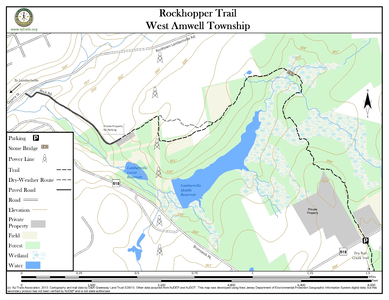
Overview of Selected Trail
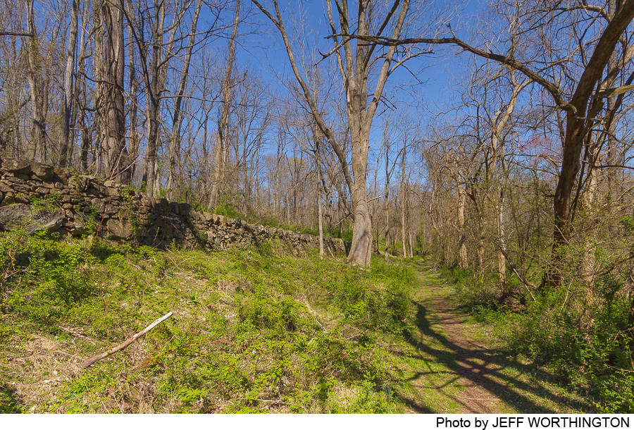
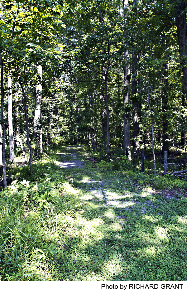
The trail ascends slightly through mature hardwood forest, winding between numerous small abandoned 19th century quarry pits. It then descends along a hillside that drains into the Lambertville Water Company reservoir, and reaches old Rock Road, along which General Washington marched on his way from Lambertville to the battle of Monmouth in 1778. The trail follows this old route for only 50 yards or so, diverts into the woods, and then again follows the old road for about a quarter of a mile. It then follows a new path through woods, skirts a field, and emerges at its southwest corner. Crossing the corner of the field, it re-enters the woods. After a few hundred yards, at a fork, the main blue-marked trail goes left, and alternative orange-marked trail goes straight. The main trail emerges on a power line corridor and follows it to the right (north). Where the orange trail rejoins the blue trail, the path heads down off the power line corridor and follows another segment of the historic Rock Road, now looking more like a streambed. The trail comes out onto the end of modern-day but unpaved Rock Road, which descends along the steep northern slope of the Swan Creek valley down to Quarry Street in Lambertville.
-
-
Distance:
2.3 miles from trailhead to trailhead, plus about .9 mile from the northern trailhead down to the intersection of Main and Bridge Streets in Lambertville.
Time:
About 1.5 hours one way all the way from Route 518 to Lambertville, at a pace to enjoy.
Markings:
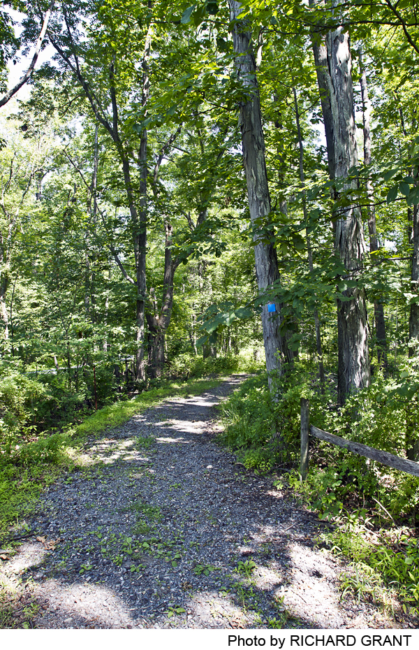
Trail marked with blue plastic blazes on trees.
Trail Usage:
Walkers only (no bikes or horses)
Elevation:
Gentle ups and downs. The trail rises from 395 feet at Route 518 to about 425 feet over its first quarter mile. It then descends to a brook valley, rises again, and then drops to 288 feet at the northern trail head, and along Rock Road and Quarry Street in Lambertville it comes down to the Delaware River plan at 75 feet above sea level.
Difficulty:
Moderate. A segment of the trail near its southern end is quite rocky (thus the name), so some care should be taken to avoid stumbling.
Parking:
At the southern end of the trail, there is a parking lot for 6-8 cars on the south side of Route 518, across from the Rockhopper Trail entrance on the north side. The parking lot is marked by a D&R Greenway sign. This parking lot also serves as the northern end of the Dry Run Creek Trail (see trail guide). At the northern (Lambertville) end of the Rockhopper Trail there is no parking. Walkers starting or finishing in Lambertville should park in town and use Quarry Street and Rock Road to connect to (or from).
Tips:
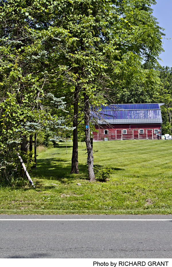
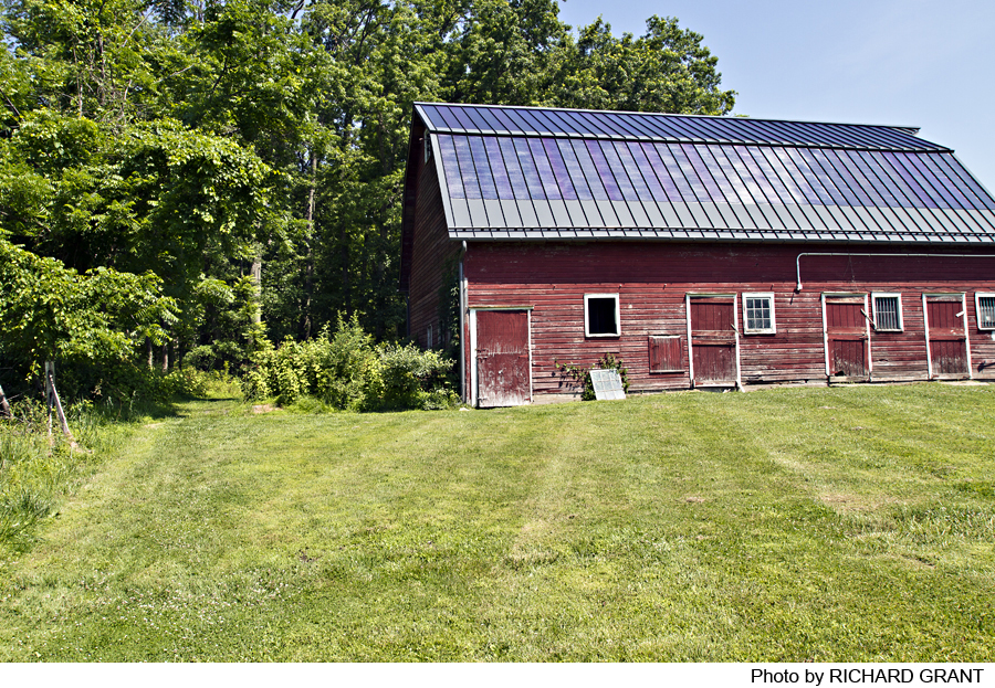
The trail’s first 500 yards or so, beginning at Route 518, follow an easement across private property. From the blue markers on trees by Route 518, walk straight back along the edge of the field, passing just to the left of the red barn. Continue straight ahead, following blue markers. Please be especially careful to stay on the marked trail and respect private property. Note also that some rocky parts of the trail can be hidden under fallen leaves in autumn, so pay attention to following the blue trail markers.
Amenities:
None.
Directions:
To the southern trail head: From Lambertville, take Route 518 east 2.1 miles to the parking lot on the right (about .4 mile beyond a broad curve where Hewitt Road joins Route 518 from the right). From the east, find the intersection of Route 31 and Route 518. Go west on Route 518, to the parking lot on the left, 5.1 miles west of Route 31 (.4 mile past the intersection with Hunter Road and Rock Road West).
To the northern trail head: Park in Lambertville and walk the .9 mile to the trail head. Walk east on Bridge Street to the main through road (Route 179 going north and Route 165 going south). Turn right, cross the main road, and walk up Quarry Street (going left at the fork between it and Route 518). Proceed up Quarry Street and turn right on Rock Road, crossing a stone bridge. Continue up the dirt road until it ends and the trail continues straight ahead as a grassy lane.
-
The trail begins on Route 518 right across from the parking lot, marked with a blue blaze. The route straight back from the road, along the field edge, may not be clearly visible in the mowed field. Walk straight back, passing just to the left of a red barn. The path then follows an old hard-surface roadway for several hundred yards. A footpath then winds up through the woods, passing the first of a dozen or more shallow pits and depressions where stone was once quarried. It picks its way through a stone-studded landscape, descending gradually and then rising gently along a north-facing slope that looks down into a low area that forms the drainage for the reservoir that supplies the city of Lambertville. The path descends to a boulder-filled creek bed where stone steps built by volunteers provide access to a convenient crossing place—but be careful if the water level is high.
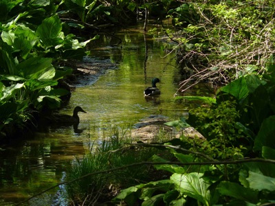
From this creek the trail curves out, in just 50 yards or less, to the historic Rock Road, at this point somewhat degraded by erosion and often quite muddy. For this reason, after turning left on Rock Road and descending for only about 50 yards, the trail route goes off into the woods to the right (east), following a gently descending and better drained route until it emerges at a stone bridge spanning the brook that feeds the reservoir, and rejoining the old Rock Road.
The trail route follows old Rock Road west for about a quarter of a mile, flanked a large part of this way by a massive and artfully laid stone wall now dated to 1762. Then, however, the old historic road becomes a deeply eroded funnel for heavy rainfall drainage, so the trail crosses the drainage on a rough wooden bridge, and curves to the left up through the woods. After about a tenth of a mile it passes the southeast corner of a well-tended field, with a view across the field of the historic hedgerow that lines the old Rock Road. The path winds through woods just south of this field, and returns to the field at its southwestern corner. The path crosses the corner of the field and re-enters the woods, coming after a few hundred yards to a fork.
From this point there are two choices. The blue-marked main route turns left and continues through the woods, sometimes in sight of another field to the left, for about a quarter of a mile, and emerges on a power line corridor. Turn right along the power line and proceed about 250 yards. The alternate,route, marked orange, also descends to the power line corridor and rejoins the blue route, but much of the year , during and after wet weather, it can be very muddy.
By either route you will arrive at a point along the power line just south of where the old Rock Road crosses it as a stream bed. Markers on posts at the side of the utility corridor direct you across the corridor to the continuation of the path down beside the old Rock Road stream bed. As the path nears its northern terminus, the stream is more confined to a narrow course, and the trail concludes with a pleasant grassy lane along its historic route.
From where the trail comes out on a dirt road, with fields on your right and an historic farm house on the left, continue on foot down to Lambertville. Note the very steep drop-offs on your left down to Swan Creek, which in earlier times fed a mill below.
-
Rockhopper Trail passes through a rich and somewhat unusual landscape for this area of New Jersey. There are wonderful canopy trees, including white oaks that must date to the 18th century, as well as red oaks and beeches, mostly growing on the well-drained slopes. Young trees are evident around the quarry pits: pin oaks, shag bark hickory, tulip tree, sassafras, and black beech. The substantial understory is dominated by spicebush, with little sign of severe deer browse. Although the population of saplings from the canopy trees is sparse, there are blackhaw viburnum, a few American beeches springing from the roots of a mother tree, some ironwood, and black cherry.
The area where stone was quarried is rich with Christmas fern and an occasional wood fern, suggesting that the quarrying and hauling operations opened the forest enough to allow sufficient light in for ferns to establish a foothold. It appears that this forest was never a pasture or farm field, unlike almost every other patch of woods in central New Jersey, but it is clear that it was disturbed a hundred or more years ago because there remain skeletons of red cedars, some lying on the ground but some still standing, here and there amongst the old quarry pits.
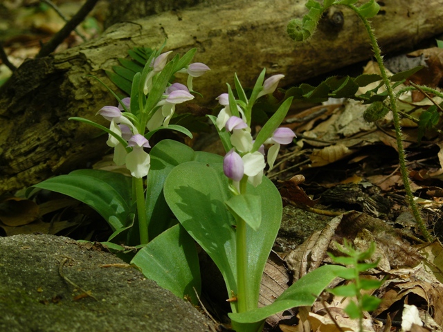
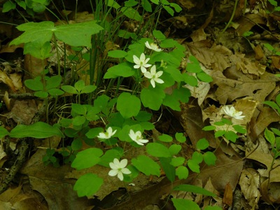
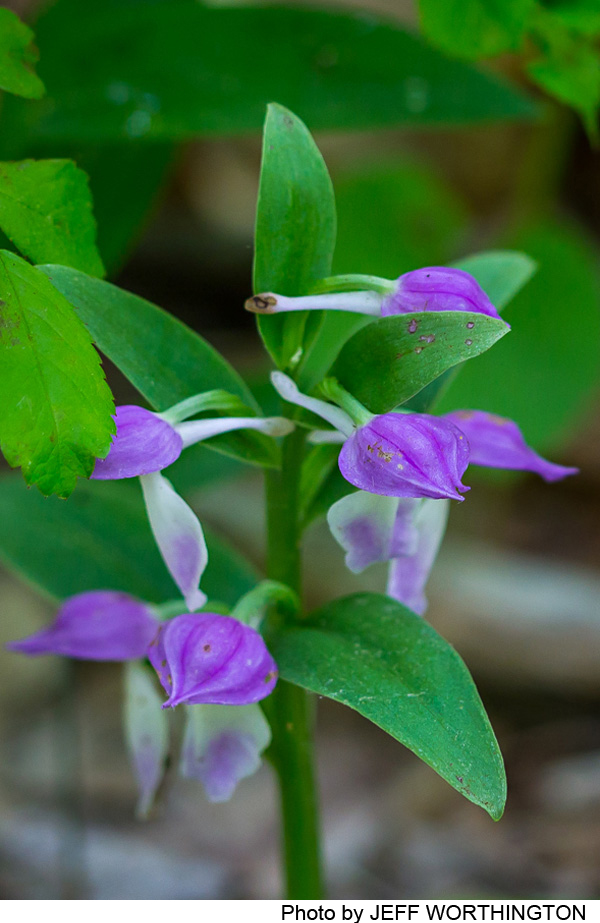
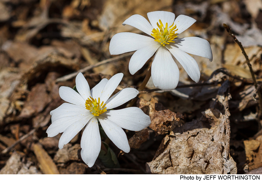
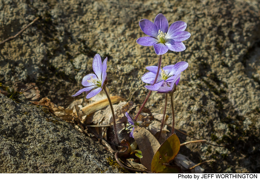
The forest floor along this trail comes alive in spring with herbaceous plants. Rue anemone dots the forest floor, and diminutive showy orchids hug the ground with their nodding pale violet and white petals. Spring beauties abound, along with cut-leaf toothwort, May apple, Jack-in-the-pulpit, various forest grasses and sedges, and violets. Along the stream that flows under the arched stone bridge about halfway along the trail, an impressive display of skunk cabbage marks the arrival of spring. The moss and lichen-covered boulders, the fabulous canopy trees, the profusion of spring flowers, and the irregular terrain combine to make this trail a great treat. Walk it slowly and savor.
Do you have information about this trail?
Click Here to contribute.
-
Walking the Rockhopper Trail is a journey back through time, to the 19th and even late 18th centuries.
Along the trail for perhaps a third of a mile near its southern end there are clear signs of past quarrying. Depressions in the ground, some subtle and some more dramatic, are now fringed with ferns, but the discerning eye will spot squared-off stones showing marks of drills, evenly spaced to create a straight cleavage line. James and Mary Gage, experts in the history of northeastern quarrying (see Stone Structures) report that these depressions are remnants of a 19th-century commercial quarrying operation to remove blocks of diabase as “dimensional stone”—high quality material for buildings, bridges, and other construction—using a method known as “plug and feather,” which originated in the early part of that century. Blocks now visible along the path are likely “trim pieces”—pieces with curved edges and often weathered surfaces that had to be removed to get at higher-quality stone that could be cut in fully regular blocks. The stone was most likely removed along Rock Road and down to Quarry Street, although the Brunswick Pike (Route 518), built in 1820-22, may also have served as a transport route.
It is possible that the walkable portions of old Rock Road by the stone bridge and wall may have been traversed by General Washington and his personal guard (of up to 100 soldiers) during the War of Independence in June 1778. General Washington, aware that the British had evacuated Philadelphia and were on the march through New Jersey toward New York, decided to lead his army from Valley Forge into New Jersey to intercept the British army en route. On June 20-21, he and his army crossed into New Jersey at Coryell’s ferry (today’s Lambertville), from which travelers could head northeast on Old York Road. The army of over 10,000 men marched beyond Coryell’s Ferry on Old York Road to their encampment site near Mt. Airy. Washington and his contingent of guards, however, stayed at Coryell’s ferry for two days, then left on June 23rd. The route taken by Washington and his life guards may have been a route going directly east as described by Sarah A. Gallagher in her book 1703-1903: Early History of Lambertville, NJ.
According to the author, this route was told to her by the then “aged” son of Captain George Coryell—presumably his son Jesse, who lived until 1861 and was a teenager in 1778. If so, Jesse could have witnessed the soldiers leaving Coryell’s ferry at age 17 and recounted the event to Sarah Gallagher over 60 years later. Writing her book in 1903, Sarah Gallagher would have recalled Jesse Coryell’s story, told to her over 40 years earlier.
Sarah Gallagher described the soldiers’ route from Coryell’s ferry as follows: “The road was at the foot of the crossed “Swan’s Creek,” then ascended the “Old Saw-mill Road” to the high ground, or “Farmers’ Highway,” which was a steep ascent. Although Sarah Gallaher does not mention Rock Road, this road, which may have been named later, would have been the only road going directly east from Coryell’s ferry toward Rocktown or Linvale near Route 31, the most logical and direct route for Washington to join his army marching southeast from the Mr. Airy camp site on its way to today’s Hopewell Borough. After leaving their Hopewell encampment on June 25th, Washington led his army farther east to attack the British army at the battle of Monmouth on June 28th.
The old Rock Road should not be confused with today’s Rock Road or Rocktown Road. Old Rock Road may have been a “private road” made by landowners and never designated as a “public road.” The earliest recorded public road from Lambertville east to Rocktown in the Hunterdon County “road returns” was in 1829. The road description reference to “the commonly called Rock Road” as a starting point indicates there already was a Rock Road.
For readers interested in reading a detailed account of the route taken by Washington’s army from Coryell’s ferry to Hopewell, see Tom Ogren’s article, Marching Through the Sourlands: The Route of the American Army to the Battle of Monmouth, at www.sourland.org/sourland-stories.
The visible remnants of the old Rock Road were part of the main route between Lambertville and Hopewell until the construction of the Brunswick Pike in the 1820s. Farming and other operations continued along this road into the 20thcentury. A detailed 1873 Beers Atlas map shows buildings along Rock Road, most of which can still be seen as stone foundations, identified on that map by their owners: E. Titus and J. Phillips. The Phillips property, according to old deeds, is purported to have been a grant from King George II of England in 1750. The property was used for operation of a farm and a sawmill, and ice harvesting from a lakebed down by the current-day reservoir and its inflow. The massive stone wall flanking Rock Road has been dated to 1762, and was probably built to retain the hillside above the road, and thus to protect the road and the large barn whose foundation can still be seen in the woods about 100 feet above the wall. The Titus property consisted of a group of at least four buildings, whose foundations are still readily visible; they are not directly along the trail route, but in the future may be linked to the main route by a spur trail.
The trail crosses a 19thcentury stone bridge spanning the small brook that now feeds into the Lambertville reservoir. Although the bridge cries out for restoration, its main features are still clearly visible and serviceable. Step off the trail down to the brook on the downstream (western) side of the bridge and you will see a perfectly intact stone arch. On that same side of the bridge the stone parapet is still in fine shape. On the opposite side, we are told, the parapet is missing because a local farmer in the 1960s found the bridge too narrow for his equipment and intentionally knocked down the parapet to make room. Its stones sit in the stream bed, obscuring the bridge’s arch on the east side.
Do you have information about this trail?
Click Here to contribute.
-
Photos
Videos
