Hunterdon
Lambertville
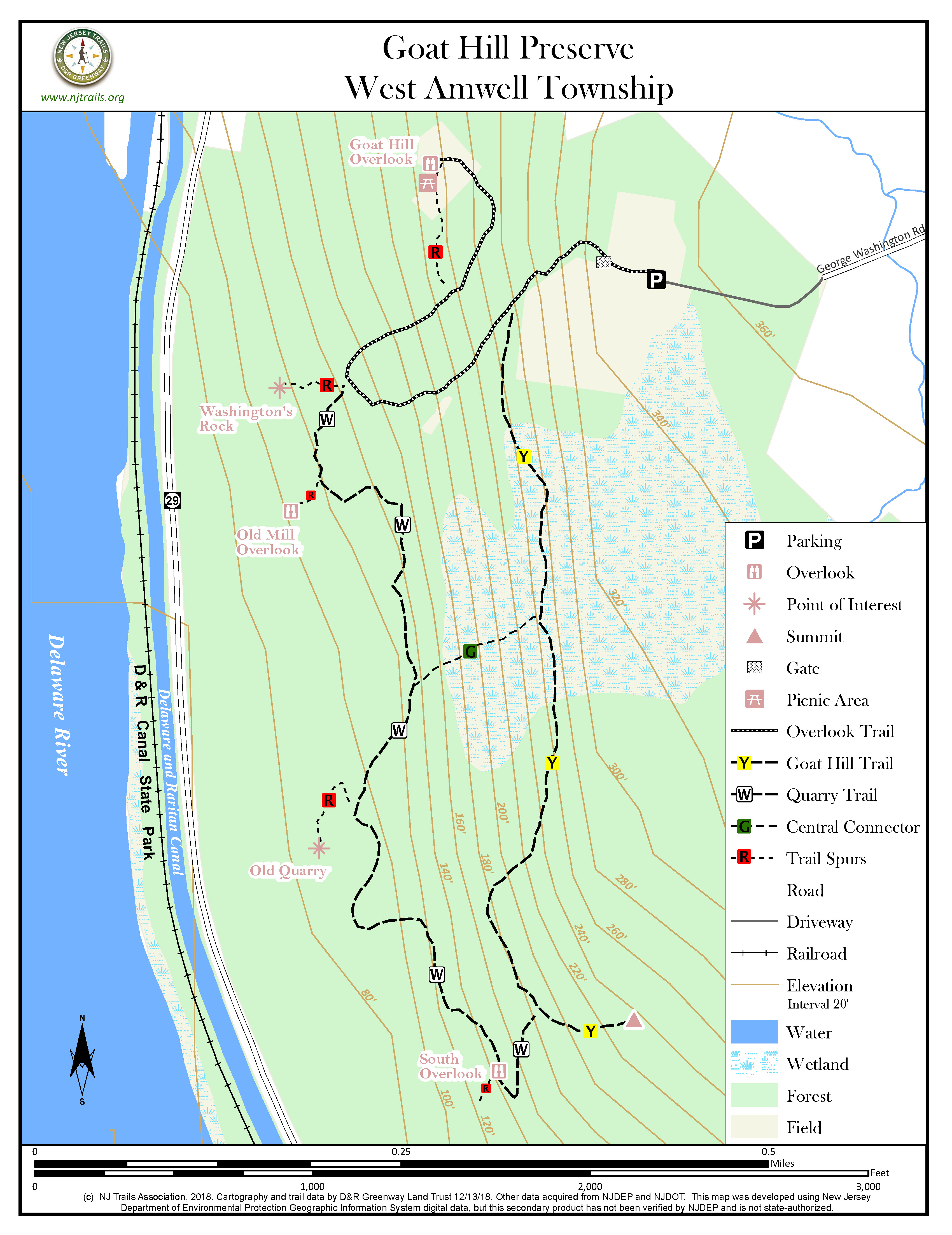
Goat Hill Preserve
Lambertville, NJ


Last Updated: 01/15/2019
Overview of Selected Trail
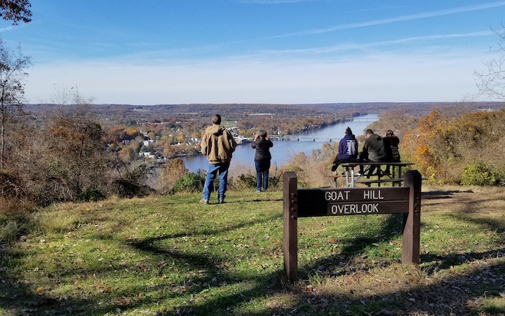
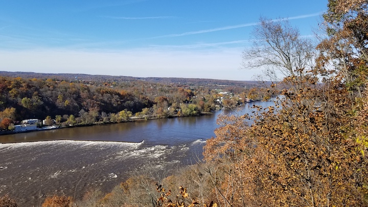
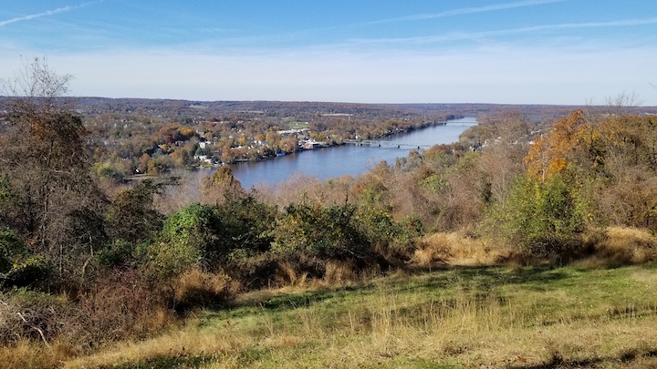
This preserve perches on a high ridge above the Delaware River just south of Lambertville. Although the preserve is short on “improvements,” it offers numerous trails through mature hardwoods and spectacular views of the river to the north, west, and south from overlook points arrayed along the length of the preserve.
-
-
Distance:
The main Overlook Trail to the Goat Hill Overlook is about .6 mile one-way. The Goat Hill Trail is about .7 mile one-way and the Quarry Trail about .5 mile one-way.
Time:
Hiking the Overlook Trail round trip can be done easily in half an hour, but most hikers take extra time to enjoy the view from the overlook for an extended period.
Markings:
The main Overlook Trail, beginning at the parking area, follows an old crushed stone driveway to the Goat Hill Overlook, and is unmarked but obvious. The other trails are marked with painted blazes on trees: the Goat Hill Trail (yellow), the Quarry Trail (white), the Central Connector (green), and the short spurs to viewpoints and the short loop connection at the north end of the Overlook Trail (red).
Trail Usage:
Dogs on leash are permitted.
Elevation:
Mostly flat with a moderate slope on the Overlook Trail.
Difficulty:
Easy
Parking:
There is a large asphalt parking lot which can accommodate about two-dozen cars.
Tips:
Bring a camera or phone for shots from the overlooks. Exercise caution, and restrain small children, at all the overlooks. There are no safety barriers, and venturing carelessly too far out on the overlook stones could risk a long fall.
Amenities:
There are picnic tables at the Goat Hill Overlook.
Directions:
From Route 29 Heading North
From Route 29, turn on to Valley Road and take the first left on to Goat Hill Road. Go about 1.3 miles on Goat Hill Road and watch closely on the left for a street sign for George Washington Road. Then turn left. Continue straight on a crushed stone road past the blue historic marker for “Goat Hill Overlook.” There is no State Park sign. Follow the access road to an unmarked parking area on the left.
From Route 29 Heading South
In Lambertville, turn left onto Swan Street at the traffic light. Go up the hill and turn right on to Studdiford Street. Go up to the top of the hill where the street becomes Goat Hill Road. Go past the Woodcrest development at the edge of Lambertville, continue for a quarter mile and turn right at the George Washington Road street sign. Follow the road to the park entrance where there is a blue historic marker for “Goat Hill Overlook.” There is no state park sign. Follow the access road to unmarked parking area on left.
-
Access to all trails is from the parking area at the end of the access road. The Overlook Trail begins just beyond the parking area. Once a paved driveway but now mostly crushed stone, the Overlook Trail heads southwest but then bends sharply back to the northeast, and after about a half mile brings you to the most popular feature of the preserve, an overlook of the Delaware River valley from a large open lawn area. From this spot—great for picnics–walkers can go back the way they came or begin their return on a short connector path (red) that leads back to the main Overlook Trail, passing beside an area of large quarried stones of diabase rock in the wooded area at the very top of the hill.
Branching off the Overlook Trail (unmarked) are two dirt trails. The Goat Hill Trail (yellow) branches to the left (south) shortly after the start of the Overlook Trail. It extends south along the “interior spine” of the preserve to the summit of Goat Hill, the highest point in the property, near the preserve’s southern boundary (but no views there).
The second trail, the Quarry Trail (white), branches left (southwest) where the Overlook Trail is bending sharply to the right. Very shortly after the start of the Quarry Trail, a spur path (red) leads down to what is called “Washington’s Rock,” a large stone promontory, extending out past the tree line, that provides an unobstructed view of the Delaware River and the Pennsylvania side of the river. (Use caution here!). The Quarry Trail, roughly paralleling the river and the Goat Hill Trail, extends south nearly to the preserve boundary and then bends east to join the Goat Hill Trail. There are partial views at the South Overlook where the Quarry Trail makes that sharp bend. It passes through another point of interest, an old abandoned quarry dating back to the late 1800’s.
A Central Connector path (green) makes it possible to create loop walks of different lengths. It provides quick access from the Goat Hill Trail to the Quarry Trail and the old quarry site.
There are two more points of interest in addition to the Goat Hill and South Overlooks and Washington’s Rock. Going south along the Quarry Trail from Washington’s Rock, one first encounters the Old Mill spur trail (red), leading to an overlook of the river directly down to the spillway remains of former mill sites. Further south, another spur marked in red leads to the Old Quarry, where remains can be seen of quarrying operations dating back to the early 1900s.
-
The preserve land is largely covered with mature hardwoods including poplar, oak, hickory and ash. Although the flat part of the site was probably cleared in the 19th century, as evidenced by long stone walls crossing the site, by 1930 aerial photos showed that almost the entire site was wooded.
Do you have information about this trail?
Click Here to contribute.
-
In the 18thcentury, Goat Hill was owned by Emanuel Coryell, who was given a license to operate a ferry across the Delaware River at present day Lambertville by King George II in 1733. Coryell acquired over 1,000 acres, including the southern part of Lambertville and all of Goat Hill. After Emanuel’s death in 1748 and the marriage of his widow in 1760, one of his five children, Cornelius, inherited the Goat Hill portion of his estate. Cornelius Coryell lived on Goat Hill until his death in 1831.
In the late 19th century, a part of Goat Hill facing the Delaware River was used as a quarry for at least 40 years. The Goat Hill Quarry was referred to in a New Jersey State Annual Geological Report in 1888 and was still operating until 1930. Photographs of the quarry operation appeared in postcards from the early 20th century. They showed a large expanse of exposed rock facing the Delaware River and quarry equipment. Since the quarry was at a high elevation, the company was able to take advantage of gravity to get the rock down to waiting railroad cars at the base of Goat Hill. According to the 1888 geological report, the quarry produced Belgian blocks rather than crushed stone. The Belgian blocks, similar to those used as ballast in ships coming from Europe, were used for paving streets in nearby large cities.
The land was eventually owned by Col. Kenneth MacIntosh, who donated the land to the Boy Scout’s George Washington Council in 1964. The site at that time included MacIntosh’s rustic lodge overlooking the Delaware River and an access drive which was later used by the scouts. The scouts pitched tents in a large field near the entrance and off the trail going south to the Goat Hill summit. Drinking water was piped to the site, and a 3-foot high pipe with a faucet still attached remains standing near the Overlook Trail. The scout council had financial challenges, however, and nearly 20 years after the donation, the Council decided in 1983 to sell the land for $605,000 to the Silvi Concrete Company of Morrisville, PA.
In 1984, Silvi Concrete attempted to obtain a zoning variance from West Amwell Township to allow a quarry use. Following strong public opposition, the Township Committee decided not to support the quarry operation, and the Township’s zoning board rejected Silvi’s request for a zoning variance. That rejection led to prolonged litigation, but eventually the Appellate Court upheld the zoning board’s decision. A subsequent Silvi plan for a 26-home housing development consistent with zoning was never pursued with West Amwell Township.
The long battle over the future of Goat Hill involved many parties. The non-profit Save West Amwell Township (S.W.A.T.) mobilized citizen opposition to the planned development. D&R Greenway Land Trust took an early interest, and in 2005 acquired an adjacent 54-acre property to undermine the development potential of Goat Hill. The State’s Green Acres program, which had been eying the property since the 1990s, made an offer to Silvi in 2006, but it was rejected. In 2008 D&R Greenway worked out a deal under which Silvi would sell Goat Hill and use the proceeds to buy another similar quarry site in Somerset County. This long campaign allowed the Green Acres program to preserve all of the remaining Goat Hill land in 2009, protecting the 267 acres and the unique geographical setting overlooking the Delaware River for approximately $4.8 million.
No history of the site would be complete without mention of the legend that George Washington went up to what is now called Washington’s Rock overlooking the Delaware. According to Hannah Coryell Anderson’s 1928 history of General Washington at Coryell’s Ferry,Martin Coryell, the great grandson of Cornelius’ brother, claimed that Cornelius Coryell ascended Goat Hill with General Washington to view the banks of the river on the Pennsylvania side to make sure that his army’s boats, to be used for the crossing down river on December 26, 1776, could not be seen by the British. Martin Coryell, who was 16 years old when Cornelius Coryell died, may have heard the story directly from Cornelius Coryell.
This historical text is drawn largely from the more detailed history of Goat Hill in “The Story of Goat Hill: From the Revolutionary War to the Fight to Save It,” published by the Sourland Conservancy.
Do you have information about this trail?
Click Here to contribute.
-
Photos
Videos
