Mercer
Hopewell Township
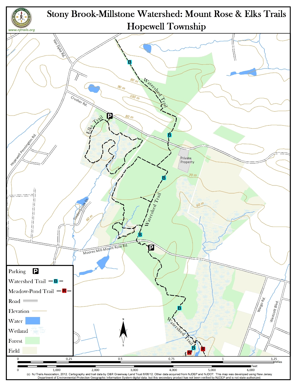
Stony Brook-Millstone Watershed: Mount Rose Trails
Hopewell Township, NJ 08525


Last Updated: 01/23/2013
Overview of Selected Trail
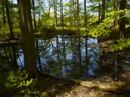
The 240-acre Mount Rose Trails consists mostly of old growth field, but also contains a mature oak-hickory forest, skunk cabbage swamp, vernal pools, the unique geological formations of the Mt. Rose Ridge and the headwaters of the Honey Brook.
There are several different trails that can be accessed from the Mount Rose Trails parking area, including Elks Trail shown on this trail map (see Elks Trail Guide).
-
-
Distance:
Mount Rose Ridge Trail: 2.1 miles round trip;
Forest Loop: 1 mile round trip;
West Loop: 1.3 miles round trip;
Cattail Trail: 1.5 miles round tripTime:
One half hour to two hours, depending on trail and pace. This trail connects to Elks Trail – also posted on this website under Hopewell Township.
Markings:
Trails are mowed through fields and marked with white Watershed logo markers.
Trail Usage:
Walking/Hiking, Dogs permitted on leash
Elevation:
From 200’ to 250’
Difficulty:
Easy to Moderately Difficult
Parking:
Mt. Rose Parking area off Moores Mill-Mt. Rose Road. Parking area is temporarily chained, but offers pull-off parking to several vehicles.
Tips:
All trails leave from the trailhead at the parking area. Please keep dogs on leash and clean up after them! Please use caution when crossing the road.
Amenities:
A small portable bathroom is available from April-November. After your hike, visit the Buttinger Nature Center, the one story red building on the reserve. The Nature Center houses a number of interpretive displays, a small shop and bathrooms. Center is open Tues-Fri 10am-5pm and most Saturdays 10am-4pm. Please visit the Stony Brook-Millstone Watershed Association for more information.
Directions:
FROM NORTH/SOUTH JERSEY
Take Route 1 to Rt. I-95 South. Get off at Exit 4 – Rt. 31 North. Take Rt. 31 through the Pennington circle. Continue on Rt. 31 North through a blinking traffic light to the 3rd regular traffic light. Turn right onto Titus Mill Road. Follow Titus Mill Rd for 1.5 miles to Wargo Road. (You will pass the entrance to the Reserve Headquarters. At the next intersection, Turn left onto Wargo Road. Follow Wargo Road to the end and turn left onto Moores Mill – Mt. Rose Road. The parking area will be 1 mile up on your left.FROM PRINCETON- MERCER COUNTY AREA
From Rt. 206, turn onto Cherry Valley Road. After about 2.5 miles, continue straight at the light at Great Road. Continue on Cherry Valley Road for about 2.5 miles, continue straight. Note: The road becomes Pennington- Rocky Hill Road. Take the first right onto Moores Mill – Mt. Rose Road. Continue past the Watershed sign at Wargo Road and the parking area will be 1 mile up on your left. -
All trails leave from the trailhead at the parking area. Please use caution when crossing the road.
After crossing the road from the parking area, the Mt. Rose Ridge trail wanders through mature oak-hickory forest. A connection to the Forest Loop on the left is reached at .15 and the Cattail Trail connection on the right is passed at .16 miles. The Forest Loop offers a stroll through the oak-hickory forest with an observation platform overlooking a skunk cabbage swamp. The Cattail Trail heads east, winding its way through an old field, crossing the Honey Brook, and ending near the headwaters of the brook.
Continuing on the main trail, a meadow is reached at .23 miles. An observation platform overlooking a vernal pool is at the far end of the field to your left. From here the East Loop heads to the right and West loop heads to the left. Both loops meander through thickets of multi-flora rose and eastern red cedar and hook back up with the Mt. Rose Ridge trail. The Mt. Rose Ridge trail passes two more fields on your left before reuniting with the East Loop at .4 miles and the West Loop at .44 miles.
From here, the trail heads through younger, denser forest until it crosses Crusher Road at .58 miles. The trail reaches the top of the Mount Rose Ridge at .64 miles. Just beyond the top, a large rocky outcrop offers an overlook of farms in the Hopewell Valley and views of the Sourland Mountains to the left. The trail continues along the ridge and then turns right, heading down the ridge. As the trail levels out, it wanders among towering tulip, oak and ash trees. The trail ends at 1.05 miles. (A future link to Hopewell Borough is planned when necessary land acquisition is completed.)
To learn more about the Watershed please visit the Stony Brook-Millstone Watershed Association.
-
The Mount Rose Trails support a wide array of plants and animals. Oak, hickory, beech and ash can be found in the forested sections along with wild turkey, great horned owls, mayapples and sensitive fern. Goldenrod, foxglove-beardtongue and milkweed are just a few wildflowers that can be found in the fields. Every spring, two small vernal pools host a large number of wood frogs that come to mate and lay eggs. Tadpoles can be seen from March through late April. Rocky outcrops of diabase, interspersed with tulip, birch and spicebush, dominate the Mt. Rose Ridge. Pileated woodpeckers have been spotted on top of the ridge as well. Unique plants like black cohosh and maidenhair ferm are found just north of the Mt. Rose Ridge.
Do you have information about this trail?
Click Here to contribute.
-
The original 200-acres of the Mount Rose Trails section was added to the Reserve in 1998 through the green Acres acquisition program. The additional 40 acres, originally preserved under Green Acres in 1998, was added to the Reserve in late 2003 through a management agreement with Mercer County. Many of the current trails were kept from the previous owner’s trail system, as well as extensions added by Eagle Scouts and in partnership with Friends of Hopewell Valley Open Space.
Do you have information about this trail?
Click Here to contribute.
-
Photos
Videos
