Mercer
Hopewell Township
Stony Brook-Millstone Watershed: Main Reserve
Hopewell Township, NJ 08534

Last Updated: 01/22/2013
Overview of Selected Trail
The Reserve Headquarters Overview:
The Stony Brook-Millstone Watershed Reserve is a part of the Stony Brook-Millstone Watershed Association. The association is a private, non-profit organization dedicated to protecting and preserving the 265-square mile area drained by the Stony Brook and Millstone River. The reserve totals 930-acres of land that is owned and managed by the Association. The reserve has three access points: Reserve Headquarters, Pond House and Mount Rose Trails. There are over 10 miles of trails on the reserve that can be linked together for short strolls or longer walks.
There are several different trails that can be accessed from the Reserve Headquarters. Listed here are a few of the more popular loops, but please consult your trail map for a full view of all trails on the reserve.
After your hike, visit the Kate Gorrie Butterfly House. The 1500 square-foot display houses native plant and butterflies. Interpretive information is available inside the Butterfly House, which is open daily from May through September.
-
-
Distance:
Four Seasons Trail: 1.1 miles round trip
Stony Brook Trail: 2.5 miles round trip
Circle Trail: .85 miles round trip
Pond Loop: .62 miles round trip
Red Shale Trail: .7 miles round tripTime:
Four Seasons Trail: 45 minutes – 1.5 hours
Stony Brook Trail: 1.5 – 3 hours
Circle Trail: .5 – 1 hours
Pond Loop: .5 – 1 hours
Red Shale Trail: .5 – 1 hoursMarkings:
Four Seasons Trail: White Watershed logo markers.
Stony Brook Trail: White Watershed logo markers.
Circle Trail: White Watershed logo markers.
Pond Loop: White Watershed logo markers.
Red Shale Trail: Trail is mowed through fields.Trail Usage:
Walking/Hiking
Elevation:
Four Seasons Trail: None
Stony Brook Trail: None
Circle Trail: None
Pond Loop: Minimal
Red Shale Trail: MinimalDifficulty:
Four Seasons Trail: Easy
Stony Brook Trail: Moderate
Circle Trail: Easy
Pond Loop: Easy
Red Shale Trail: EasyParking:
Four Seasons Trails: Parking Lot at Reserve
Stony Brook Trail: Parking Lot at Reserve
Circle Trail: Parking Lot at Reserve
Pond Loop: Wargo Road – parking for 3-4 cars
Red Shale Trail: Wargo Road – parking for 3-4 carsTips:
N/A
Amenities:
For further information and to learn more about the watershed, please check the website at SBMWA.
Directions:
Reserve Headquarters
FROM NORTH/SOUTH JERSEY
Take Route 1 to Rt. I-95 South. Get off at Exit 4 – Rt. 31 North. Take Rt. 31 through the Pennington circle. Continue on Rt. 31 North through a blinking traffic light to the 3rd regular traffic light. Turn right onto Titus Mill Road. Follow Titus Mill Rd for 1.2 miles to Watershed entrance on your left. Parking area is at the end of the driveway.FROM PRINCETON- MERCER COUNTY AREA
From Rt. 206, turn onto Cherry Valley Road. After about 2.5 miles, continue through 4-way stop at Great Road. After another 2.5 miles, cross traffic light at Carter Road. The road becomes Pennington- Rocky Hill Road. After 2.25 miles a center island divides the road. At the divide, turn right onto Titus Mill Road (blue and white Watershed sign on corner). Continue past Wargo Rd. (1st right) and make the 2nd right into the driveway with the white stone pillars. Park in lot at end of driveway.Pond House
FROM NORTH/SOUTH JERSEY
Take Route 1 to Rt. I-95 South. Get off at Exit 4 – Rt. 31 North. Take Rt. 31 through the Pennington circle. Continue on Rt. 31 North through a blinking traffic light to the 3rd regular traffic light. Turn right onto Titus Mill Road. Follow Titus Mill Rd for 1.5 miles to Wargo Road. (You will pass the entrance to the Reserve Headquarters) Turn right onto Wargo Road. Pass the Watershed Organic Farm and parking is just outside the metal gate where the road bends sharply right. PLEASE DO NOT BLOCK THE GATE.FROM PRINCETON- MERCER COUNTY AREA
From Rt. 206, turn onto Cherry Valley Road . After about 2.5 miles, continue through 4-way stop at Great Road. After another 2.5 miles, cross traffic light at Carter Road. The road becomes Pennington- Rocky Hill Road. After 2.25 miles a center island divides the road. At the divide, turn right onto Titus Mill Road (blue and white Watershed sign on corner). Take first right onto Wargo Rd. Pass the Watershed Organic Farm and parking is just outside the metal gate where the road bends sharply right. PLEASE DO NOT BLOCK THE GATE. -
The Four Seasons Trail
The Four Seasons Trail is a self guided nature trail with 17 stations. Pamphlets are available at the trailhead and change with each season. This trail allows the hiker the shortest and quickest access to the Stony Brook. The trail does intersect Titus Mill Road, so use extreme caution when crossing. The trail can be muddy, especially in the spring. Adequate footwear is a must.
Summary Description:
A sign marks the trailhead that is opposite the main parking area. Across the driveway from the trailhead is a large white house, the J. Seward Johnson, Sr. Environmental Center. This house, built in the 1850’s, contains offices of the Watershed Association.
The trail begins in an old field dominated by multiflora rose. The trail forks at .05 miles. Hikers should stay to the left on the trail to follow the interpretive route. At about .2 miles, the trail crosses Titus Mill Road and enters a stand of pines on the other side. Please use extreme caution when crossing the road. The trail wanders through rows of red pine, white pine and eastern red cedars. Eventually the evergreen stand gives way to a deciduous forest containing red maple, ash and elm. The trail bends and reaches the Stony Brook at .6 miles. The Stony Brook is the major waterway in this area and meanders 21 miles where it joins up with the Millstone River at Lake Carnegie in Princeton. As the trail leaves the Stony Brook, it passes again through the deciduous forest and back into a stand of white and red pines and larches. The trail again crosses Titus Mill Road at .9 miles and finishes up in the old field where it began.The Stony Brook Trail
The Stony Brook trail offers the hiker a longer route to the Stony Brook. Covering the western portion of the property, it passes through both forest and open field, offering access to some of the more secluded spots on the reserve. The trail can be muddy, especially in the spring. Adequate footwear is a must.
Summary Description:
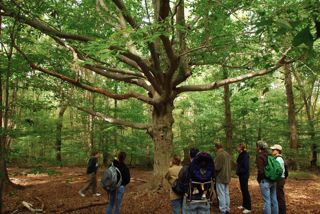
The trailhead is located behind the J. Seward Johnson Sr. Environmental Center, which is the white building across from the parking area. This house, built in the 1850’s, houses offices for the Watershed Association. At the trailhead there is a map box and an interpretive board that highlights some of the natural activities on the reserve. Going left from the trailhead, the trail begins in a field, quickly passing through a small hedge. It re-enters a field on the other side. The trail stays at the edge of the field and enters the forest at 0.1 miles. A long string of temporary boardwalks lead you to a bridge that crosses a small stream. Staying right after the bridge, the trail splits at 0.3 miles – take the left fork. A signpost marks this intersection. The trail wanders through open forests and small stands of evergreen. An interpretive signs marks the site of an old American Beech or “Hobbit Tree” at about 1.1 miles. The trail continues through open woods as the Stony Brook appears on your left. At approximately 1.5 miles, the trail turns sharply right. An interpretive sign about the Stony Brook and view of the Hopewell Valley Golf Club mark this turn. The trail moves out of the woods, into an old field and eventually comes to an intersection at 2.0 miles. A low cut field, –maintained for grassland birds–, is on your left. Turning right at this intersection, the trail cuts between an old-field and meadow, reentering the forest at 2.15 miles. The trail passes a sign for the Stony Brook Trail at 2.25 miles, leaving the forest and passing through the fields back to the trailhead at 2.5 miles.
Circle Trail
The Circle Trail allows the hiker to experience both field and forest habitat over a very short distance. The trail connects with several other trails including links to the Organic Farm, Pond House and Wildflower Trail. It also offers views of the historic barn and the quarry on Pennington Mountain. The trail can be muddy, especially in the spring, so adequate footwear is a must.
Summary Description:
The trailhead is located behind the J. Seward Johnson Sr. Environmental Center, which is the white building across from the parking area. This house, built in the 1850’s, houses offices for the Watershed Association. At the trailhead there is a map box and an interpretive board that highlights some of the natural activities on the reserve. Turning right from the trailhead, the trail passes along a meadow. These fields are cut every few years to halt the successional process that slowly turns them into forests. A T-intersection is reached at 0.1 miles where the trail turns left and runs through the field and then along the edge of the woods. (Note: A right hand turn leads a hiker to the Wildflower Trail) The first branch of the circle trail is on the left at 0.2 miles. Continue on to the second branch at 0.26 miles. The trail turns left and enters into the forest. (Note: The trail that continues straight passes by benches in another 0.05 miles and reaches the Organic Farm on Wargo Road at 0.23 miles. The benches are a wonderful spot to watch the sun set over the fields to the west.) The trail winds through forest dominated by red and white oak and shagbark hickory and emerges into a field at 0.4 miles. Turning left, the trail heads west along the edge of the forest. (Note: A right hand turn connects the hiker to the Pond House in another 0.25 miles) At 0.52 miles, the trail turns left and re-enters the oak-hickory forest. The trail exits the forest at .63 miles, following the edge of the forest. A right hand turn at 0.72 miles leads back through the field to the trailhead.
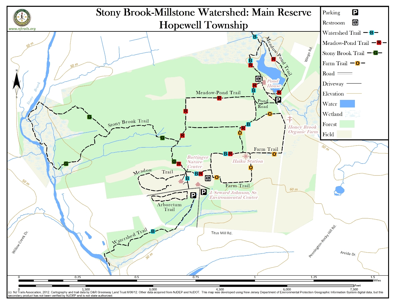
Pond Loop
Pond House Overview:
There are several different trails that can be accessed from the Pond House. Listed here are a two of the more popular loops, but please consult your trail map for a full view of all trails on the reserve. The Pond House area can be reached from the parking area off Wargo Road or by taking the Circle Trail from the Reserve Headquarters and accessing a connecting trail. (see description for Circle Trail)
The Pond Loop allows the hiker wonderful views of this 3-acre pond. Two side trails offer close up-views of the pond and the island. The Pond Loop passes through hardwood swamp and along several wetland areas, including a cattail marsh. The trail is usually muddy year round. Adequate footwear is a must.
Summary Description:
The Pond Loop trailhead begins at the kiosk just beyond the gate by the parking area. Turning right from the kiosk, the trail runs along the top of the earthen dam built to create the pond. The dam offers good views of the island in the pond and the cattail marsh opposite the pond. The trail leaves the earthen dam and winds its way through young forest of eastern red cedar, ash, red maple and occasional swamp white oak. Watch for side trails at 0.15 miles and 0.3 miles that offer good views of the pond. The trail crosses the Honey Brook at .4 miles and loops back around to end at the Pond House at .62 miles.
Red Shale Trail
The Red Shale Trail is a short loop that meanders through old field dominated by multi-flora rose and eastern red cedar, as well as a younger field with a wide variety of flowers and grasses. The Red Shale Trail also hooks up with the Stony Brook Trail for a longer walk.
Summary Description:
Leaving the Pond House, walk south along the dirt road. Opposite the two old grain silos, the Red Shale Trail turns right. It wanders through second growth field until it intersects with the Stony Brook Trail at .36 miles. At this intersection, the field to your right is maintained as grassland to encourage the return of birds such as grasshopper sparrows and bobolinks. Turning left, the trail moves along with old field on your left and younger, open field on your right. Watch for American kestrels and northern harriers hunting along the open field. At .64 miles, the trail returns to the dirt road. A left hand turn returns the hiker to the Pond House at .7 miles.
-
The Reserve is well-blended combination of forests, fields, streams, ponds and wetlands. The diversity of habitat allows for an array of plants and animals. The fields are wonderful places for wildflowers including, milkweed, Queen Anne’s lace, yarrow, black-eyed Susan, and mountain mint to name just a few. Several species of butterfly have been seen including monarchs, black swallowtails, great spangled fritillaries and a host of skippers. The combination of open fields with edges allows for a wide variety of birds including prairie warblers, field sparrows, bluebirds, and tree swallows. American kestrels, northern harrier, and red-tailed hawks are common birds of prey seen visiting the fields during daylight and great horned and screech owls as well as big and little brown bats in the evenings. A grassland field is maintained along the Stony Brook Trail to encourage birds such as grasshopper sparrows and bobolinks. Red fox, white tail deer, woodchucks, and meadow voles are just a few of the mammals that frequent the fields.
The forests are predominately oak-hickory, although some of the early successional forests are still dominated by eastern red cedar. The property hosts a stand of red and white pines that were planted many years ago and can be visited along the Four Seasons Trail. Spring beauty, mayapple and cut leaved toothwort blanket the forest floor in early spring and wood thrushes, ovenbirds and scarlet tanagers provide musical background during the summer months. Wild turkey are common in the fall as are grey squirrels, feeding on acorns left by the oaks.
The Stony Brook offers quiet solitude for drawing, writing or meditation. Great blue and green herons share the brookside feeding with kingfishers. Raccoons wander the stream edges in search of crawfish and tadpoles and summer evenings are full of the calls of fowler’s toads. The brook also hosts and abundance of macroinvertebrates. Stoneflies, mayflies, water pennies and hellgrammites all are indicators of excellent water quality. Sunfish, bass, creek chubs and shiners can be found in the riffle areas and the slower moving pools of the brook.
The Pond House area offers outstanding birding from great egrets and great blue herons to kingfishers, Baltimore orioles and a host of waterfowl. Several species of amphibians can be found including spring peepers, bullfrogs, green frogs and pickerel frogs. Painted turtles are often seen basking on logs along the shore and occasionally a snapping turtle can be seen rising to the surface.
Please visit the Buttinger Nature Center for a complete list of butterflies, reptiles, amphibians, and mammals found on the Reserve. Other species lists, including birds, are currently underway.
Do you have information about this trail?
Click Here to contribute.
-
The Reserve Headquarters
The Reserve Headquarters sits on the site of the former Brookdale Farm. The farmhouse, windmill and barn date back to the 1850’s. The Reserve is the result of the vision of an extraordinary woman, Dr. Muriel Gardiner Buttinger. Dr. Buttinger purchased Brookdale farm in 1940 and began buying the surrounding farms as their owners looked to sell. One of these farms is now the current Watershed Organic Farm and the site of the Pond House. In 1965, Dr. Buttinger made her first gift of land to the Watershed Association totaling 400 acres. From 1969-1984, she made several more gifts of land and buildings to the Association that totaled 17 buildings and 535 acres of land. These gifts are lasting symbols of not only her generosity and selflessness, but also her commitment to this region. If you would like to know more about Dr. Buttinger, please inquire at the Buttinger Nature Center.
The Pond House
The Pond House sits on the site of an old farm once owned by the Wargo Brothers. In 1970, the Honey Brook was dammed to create a research pond that has been the site of many studies focusing on groundwater. The Pond House is the site of the Association’s Environmental Education Day Camp hosting school groups in spring and fall.
Do you have information about this trail?
Click Here to contribute.
-
Photos
Videos
