Hunterdon
Bloomsbury
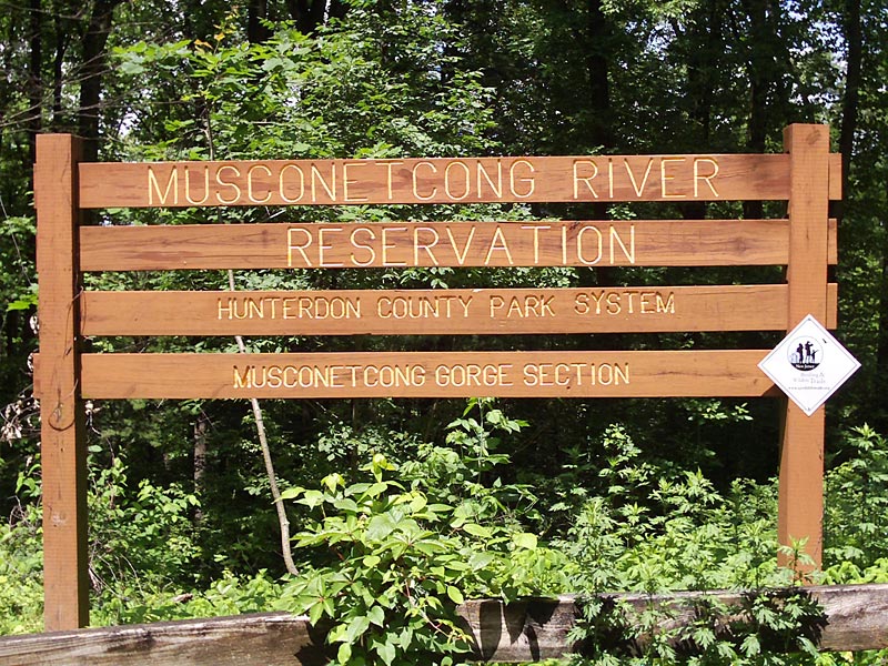
Musconetcong Gorge
Bloomsbury, NJ 08804

Last Updated: 12/26/2013
Overview of Selected Trail
A wooded nature preserve totaling 425 acres, Musconetcong Gorge formerly served as a woodlot for Warren Glenn Paper Mill, which started production in 1873 and still operates today. The Musconetcong Conservancy secured the Musconetcong Reservation, which is managed by Hunterdon County Department of Parks and Recreation. Trails are maintained by volunteer Friends of Musconetcong Gorge. The shorter of the existing trails, blazed with orange, was an Eagle Scout project; brochures on plant life along this trail are available from the Parks and Recreation offices.
-
-
Distance:
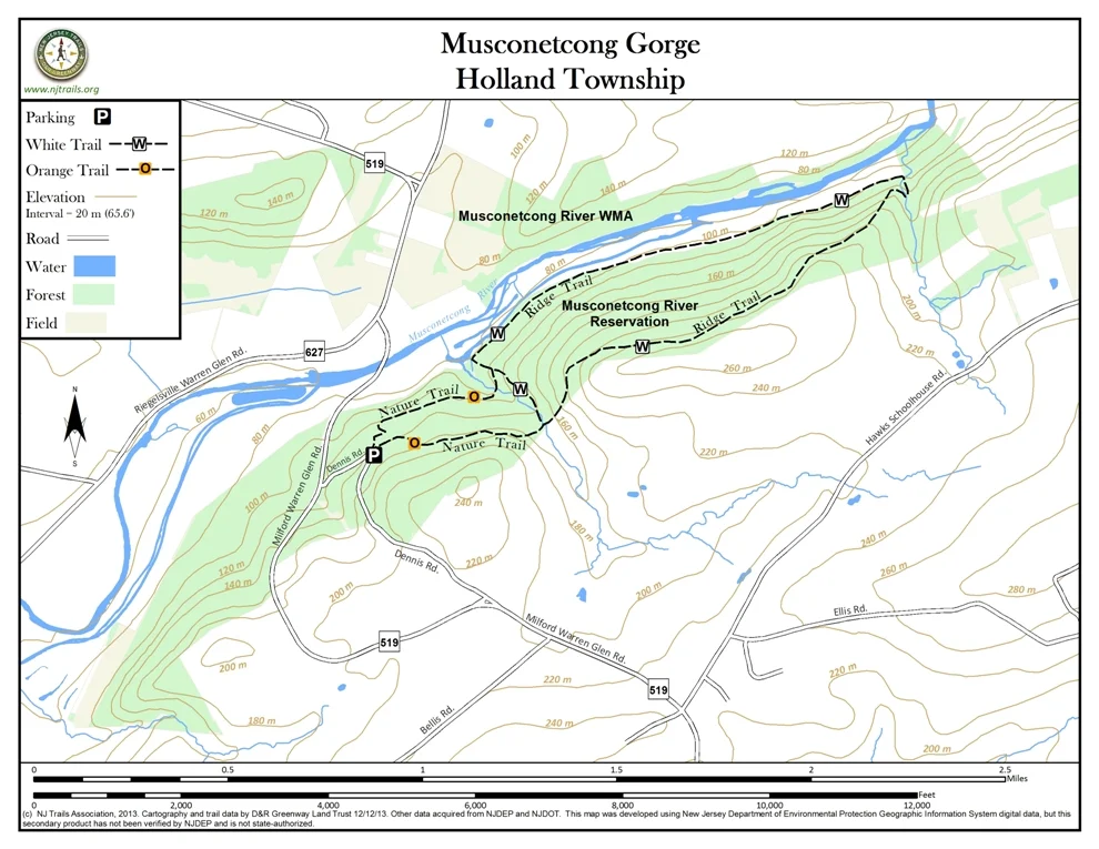
Ridge Trail (white): 3.6 miles
Nature Trail (orange): 0.5 milesTime:
Allow two and one-half hours for circuit using both trails
Markings:
Ridge Trail – white blazes/aqua blazes (Local hikers should follow the white blazes where white and aqua diverge. Aqua blazes are for future connections with longer walks outside the current reservation.)
Nature Trail – orange blazes
Trail Usage:
Walking/Hiking
Elevation:
From 330 to 800 feet
Difficulty:
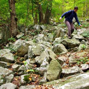
Ridge (white) Trail: moderately difficult because of steepness and loose rock.
Nature (orange)Trail: steep, but short with smooth footing.
Parking:
Lot on Dennis Rd. with room for about ten cars
Tips:
Amenities:
The Gorge section is open from sunrise to sunset. Trails are not designed for mountain bikes or horses. Deer hunting by special permit occurs from October to February. In hunting season, hikers may prefer to hike on Sundays, when hunting is prohibited.
Directions:
From Milford, NJ
- Take Route 519 North for 5.8 miles to Dennis Road
- Bear right onto Dennis Road and travel 0.6 miles to parking area on right.
From Bloomsbury, NJ
- Go north on Route 579.
- Cross the Musconetcong River into Warren County.
- Turn left (West) onto Route 173/639.
- Follow 639 for 4 miles to stop sign at Route 519.
- Turn left (south) onto Route 519 and follow it back across the Musconetcong River at Warren Glenn Paper Mill.
Take first left after the mill onto Dennis Road (gravel). From this end of Dennis Road, the parking lot is on the left at 0.2 miles from Route 519.
-
After a short walk on the Nature Trail (orange) from the parking lot on Dennis Road, the white-blazed trail runs east along the North Slope of Musconetcong Mountain. For the first half-mile, the sound of Warren Glenn Paper Mill filters through a mixed hardwood forest thick with ferns. As the sound fades, the trail enters a ravine where Scout Brook tumbles noisily across a rough service road.
A steep switchback from the ravine keeps a hiker focused on loose rocks and wildflowers underfoot. Until the trail levels off and the hiker can look around while walking, it makes sense to stop frequently and check for white blazes to avoid losing the trail. From time to time, a rare level circular area relatively free of rocks indicates a site where mill workers made charcoal in the nineteenth century.
The mountain shows signs of breaking up into angular loose fragments of rock. The largest one near the trail is as big as a moving van. Nearby, the fretwork of woodpeckers calls attention to a sassafras tree, still full of leaves though the trunk is scoured out. Where foliage is absent, broad views invite the hiker to pick out landmarks in the valley and note the flash of windshields on distant Route. 78.
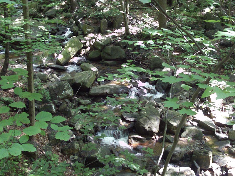
The trail eases down into the second ravine where Pine Brook’s twisted course under fallen trees and large, moss-covered boulders leads the trail to its midpoint beside small pools. The dark wet moss serves as background to highlight poison ivy leaves that merit the usual caution.
A cinder rail bed provides relief from the steep and rocky trail. It runs back west above the Musconetcong River, a small dam, and an old canal that once provided water power to the mill. Before long the sound of the mill returns, a bridge crosses Scout Brook a short distance below a waterfall, and an orange-blazed nature trail corkscrews up the mountain to the parking lot.
A shorter trip can be walked in either direction from the parking lot, using the orange trail, the service road along Scout Brook, and the white trail.
-
The mixed hardwoods include tulip poplar, hickory, various types of oaks and maples, yellow and black birch, ash, and sassafras. Such a habitat supports gray squirrels, deer, and turkeys. In recent years black bear and coyote have been seen. The ravines and springs provide excellent habitat for small reptiles and amphibians. The steep slope gives rise to thermals for soaring hawks and vultures. During spring and fall migration songbirds are abundant, and wildflowers bloom among the stones nearly all year round. Mosquitoes are not a major problem, but ticks have been found on some hikers.
Do you have information about this trail?
Click Here to contribute.
-
For more information on this trail and others in Hunterdon County please see the following website: Hunterdon County Parks Department.
Do you have information about this trail?
Click Here to contribute.
-
Photos

Videos