Mercer
Princeton
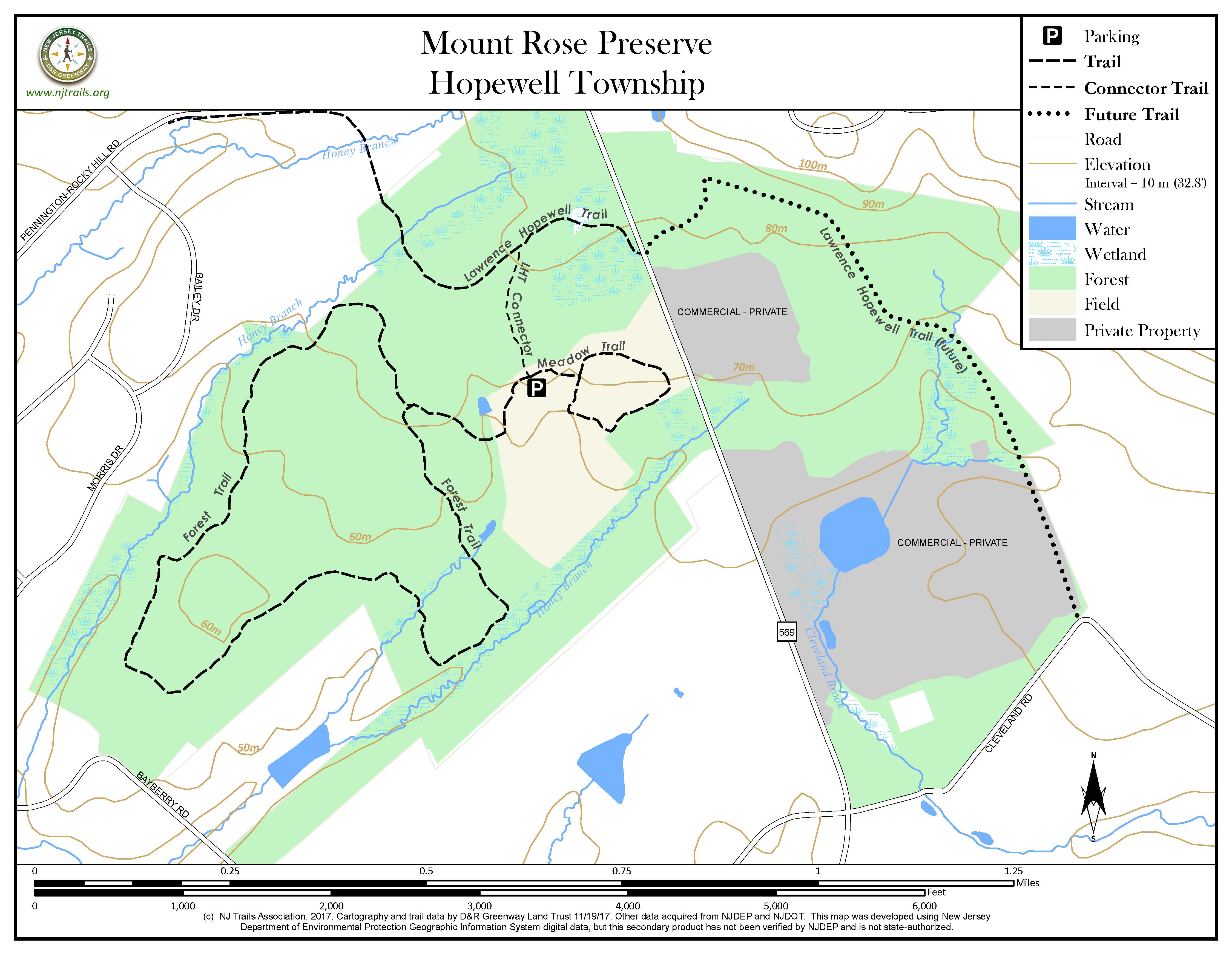
Mt. Rose Preserve
Princeton, NJ


Last Updated: 11/30/2017
Overview of Selected Trail
A two-mile trail loop meanders through a varied successional forest, with ready access from the Lawrence-Hopewell Trail.
-
-
Distance:
Forest Trail: 2-mile loop from the parking area.
Meadow Trail: 0.4-mile loop from parking area.
Lawrence-Hopewell Trail Connector: A .2-mile trail connects to the paved Lawrence-Hopewell Trail, giving walkers access from the LHT to the Mount Rose Preserve via its parking area.
Time:
Forest Trail: 60-90 minutes
Meadow Trail: 20 minutes
Markings:
Markers are attached to trees and to posts at trail junctions and in open areas; white markers for the Forest Trail, and blue markers for the Meadow Trail.
Trail Usage:
Hikers only.
Elevation:
The terrain is fairly level.
Difficulty:
Easy
Parking:
A large parking lot is located at the trailhead.
Tips:
Portions of the trails may be wet in spring or after heavy rains, especially the beginning portion of the Forest Trail and the entire Meadow Trail.
Amenities:
A kiosk with trail information is located at the parking area.
Directions:
The entrance to the preserve is from Carter Road, approximately a quarter mile south of the Mt. Rose hamlet at the intersection of Carter Road, Pennington – Rocky Hill Road, Cherry Valley Road, and Hopewell – Princeton Road. Follow the entrance driveway to the parking area. For GPS navigation, the closest address is 350 Carter Road, Princeton (located across street from Preserve).
-
Forest Trail – From early successional forest dominated by eastern red cedar, to mature mixed hardwood and stands of majestic American beech and White Oak, this 2-mile loop trail traverses the diverse forest types of the Mount Rose Preserve. Along the trail, visitors can learn about the ongoing forest restoration project. Please note that this trail is closed, except for Sundays, during the deer hunting season from early September through mid-February – signage will be posted at the trailhead.
Meadow Trail – This gentle 0.4-mile trail winds its way through meadows and shrubland habitat near the parking lot. This trail is a great place for butterfly and bird-watching during the breeding and migration seasons.
Lawrence Hopewell Trail (LHT) – The 0.4-mile section of this regional multi-use trail has been completed on the west side of Carter Road. An additional section of 1 mile is currently blazed on the east side of Carter Road, but is unimproved and open only to pedestrian use. This trail will be improved and made part of the LHT in the near future. A 0.2-mile trail from the parking lot kiosk provides access to the LHT.
-
The Preserve has an interesting mix of mature and young forests, shrublands and meadows. Large American Beech, White Oak and Shagbark Hickory can be found and admired. Dense red cedar forest and shrublands provide excellent habitat for many species of birds. Meadows with interesting mixes of wildflowers serve many pollinators. Over 300 species of plants and animals have been documented on the Preserve, including migrating and nesting warblers, Brown Thrashers, Wood Thrushes and Bobolinks. The rare Wild Comfrey depicted on preserve entrance sign flourishes on the unique geology of the Preserve.
Do you have information about this trail?
Click Here to contribute.
-
The Mount Rose Preserve site, together with two office buildings on the east side of Carter Road, was opened in 1958 as the nation’s first corporate campus. It served as the major research and education facility for Western Electric, and later AT&T. The corporate education facility, located on the west side of Carter Road and built in 1969, was torn down in 2016.
Researchers at this facility developed advances in the methods of electronics production, including the industrial use of lasers. Today the Mount Rose Preserve comprises most of the land formerly part of the corporate park. Its history as a corporate campus makes it unique among New Jersey’s open space preserves.
In 2004 the site was purchased by investors (Equus Capital Partners. Equus and its predecessor, Berwind Property Group) who proposed to redevelop the property for more than 800,000 square feet of commercial space. Had the land not been preserved, the development would have added up to 4,000 vehicles a day to rural Carter Road. Site plan approval was granted by the Hopewell Township Planning Board in 2008 but, as a result of a successful lawsuit filed by the citizens group based in Hopewell Borough which went all the way up to the New Jersey Supreme Court, the developer eventually agreed to sell the property so that it could be preserved as open space. Following negotiations led by the citizens group and NJ Conservation Foundation, the Carter Road 230-acre property was preserved in 2015 with the backing of a partnership of more than a dozen public agencies and nonprofit organizations. The land acquired on the west side of Carter Road is surrounded by over a hundred acres of preserved open space and farmland.
The Mount Rose Preserve is owned and managed by New Jersey Conservation Foundation, Friends of Hopewell Valley Open Space, Hopewell Township, and Mercer County. It was preserved by these partners along with Hopewell Valley Citizens Group Inc., NJ Green Acres Program, Stony Brook-Millstone Watershed Association, Hopewell Borough, Pennington Borough, Friends of Princeton Open Space, D&R Greenway Land Trust, Lawrence Township and Princeton Township.
Do you have information about this trail?
Click Here to contribute.
-
Photos
Videos
