Mercer
Lawrence Township
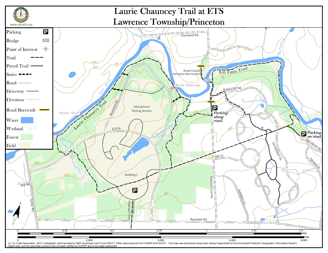
Laurie Chauncey Trail at ETS
Lawrence Township, NJ 08648


Last Updated: 06/24/2013
Overview of Selected Trail
Province Line Rd. north of Rosedale Rd. runs between ETS in Lawrence Township and the Ettl Farms development in Princeton. About ¾ mile after the intersection it ends at a barrier, beyond which the road, as a bike and pedestrian pathway, drops down and crosses Stony Brook on what used to be a vehicular bridge. It continues partway up the north bank to another barrier, beyond which it becomes a road again. On the south bank of the river, hiking trails run for almost a mile in either direction, with a 1000’ gap in between. The west (upstream) trail is part of the Laurie Chauncey Nature Trail on ETS property; the east trail is on Princeton open space land behind Ettl Farms.
-

-
Distance:
3-4 miles
Time:
Approximately 1.5 to 2 hours
Markings:
Brass circles or light green markings on posts are found only where the Laurie Chauncey Nature Trail crosses a road. The new spur to Province Line Rd. has green plastic signs with white letters and arrows.
The Lawrence Hopewell Trail (pedestrians, bikers) has dark green triangular markers with the letters LHT. It enters from Rosedale Rd. and terminates after a short distance at an LHT kiosk on the internal driveway. The route is planned to exit onto Province Line Rd., which can be done temporarily by following the gas pipeline. (see website for Lawrence Hopewell Trail.)
Trail Usage:
Walking/Hiking, Dogs permitted on leash, Mountain biking
Elevation:
Elevation gain of 100 feet from the river.
Difficulty:
Easy to moderate, although trails are not well marked in all places.
Parking:
For Laurie Chauncey, use the parking lot by Lord Hall (Bldg. L). There is no sign to indicate parking for the walking trail. The parking places on the inner rim of the parking lot are closest to the trail. For Ettl Farm trail, park along Province Line Rd. at the north end, or on the cul-de-sac at the west end of Wendover Rd. in Brookstone.
Tips:
Trail is not easy to see in places, especially in the summer.
Amenities:
Directions:
Education Testing Service (ETS) is located in the NE quadrant of the intersection of Carter Road (County Road 569) and Rosedale Road (County Road 604), with entrances on both roads.
From Hopewell: Take Carter Rd. for 2.1 miles to the ETS entrance 0.4 mile after crossing the bridge over Stony Brook. Turn left and follow the ETS Road 0.3 mile. Turn right on the first paved road and follow signs to Lord Hall. Park on the inner rim of the parking lot, if possible.
From Princeton: Take Rosedale Rd. 2 miles from Elm Rd. to the other ETS entrance. Turn right, go ¼ mile and take the first paved road to the left. Park on the inner rim of the parking lot, if possible.
-
The Laurie Chauncey Nature Trail begins and ends on the gas pipeline right of way as a mowed path through a meadow. In between, it winds through the woods down to Stony Brook and back, following the brook for the better part of a mile, with beautiful views and many bridges over intermittent streams.
Locate the path of the gas pipeline indicated by a series of three tall yellow pipes in a row. The pipeline right of way cuts across the area between the parking lot and building L. Facing the building, turn left and follow the mowed pipeline path across the road. The mowed pipeline takes a sharp turn to the right. When the mowed path takes a sharp left, continue straight ahead on the path into the young woods, and where there are multiple trails, keep to the right near the edge of the woods. When reaching the entrance road, the trail jogs to the left for 50 yards or so along a grass strip, then crosses the road (look for signpost) into a more mature woods. Look for wooden posts under a power line, as the trail approaches and then parallels Stony Brook. The path periodically crosses intermittent streams on bridges or stepping stones, and in several places trails or stairs on the right go up to a loop road. Eventually, the stream swings around to the right, and as the path starts to climb look for a rock outcropping on the left with a lovely overlook of the stream. The trail turns sharply right after crossing a bridge, and begins to follow the outlet stream from the large pond in the center of the campus, crossing it several more times. Halfway up the hill, a new trail comes in from Province Line Rd. on the left. The main trail eventually comes out on the gas pipeline right-of-way. Turn right and follow the pipeline (and/or the driveway) back to the parking lot.
This hike can be extended by going left on the trail to Province Line Rd., walking down the road about 250 yds. (passing the barrier) and following Stony Brook further downstream (see below), or by crossing the pedestrian bridge and hiking on lightly traveled country roads. Halfway down the road, note the paved bike path on the right, coming down the hill from the end of Stone Cliff Rd. (see below).
Ettl Farm Trail along Stony Brook begins at a painted sign on the right edge of the road that says “Stony Brook Trails”, located just as the road starts to turn left to cross the brook. This is another very pretty trail along the edge of the brook, with intermittent stream crossings on stepping stones. Running first to the NE and then to the SE, it eventually comes to the gas pipeline that runs down the slope from Ettl Farm and crosses the stream into Brooks Bend. At this point the trail forks; the left fork crosses the pipeline before turning to the left and coming shortly to a stepping stone crossing which parallels the pipeline into Brooks Bend. (It’s important to note that, although this crossing- not shown on the map- brings one to Brooks Bend open space land, the area is a dead end, there presently is no continuing trail, and the crossing is often under water, except during drought periods.) The right fork begins by climbing first on mini-switchbacks in the woods and then straight up the pipeline before merging with a paved bike path: going left on the bike path will bring you to the cul-de-sac at the end of Wendover Drive in Brookstone. By continuing along the edge of the pipeline, a loop can be completed by crossing Christopher Drive on the bike path and keeping to the right at a junction. The path terminates at another section of Christopher Drive, at which point one should go left for 50 yds., go right on Stone Cliff Rd. to the end, and pick up the short bike path to Province Line Rd. at the end of the road.
It should be noted that the neatly mowed pipeline in Ettl Farm is in community internal open space, and although officially not open to the public, provides a straight line alternative route from the end of the trail along Stony Brook all the way back to the main parking lot at ETS.
-
The young woodlands on the upper level at ETS are made up of swamp red maple, red cedar, and some white pine. It is relatively open with honeysuckle, grass, wild rose and poison ivy as undergrowth. The composition of the older woodlands changes as the steepness of the surrounding landscape changes. The basswood, red maple, white ash and tulip poplar are abundant in the flat area nearer the stream. The understory is made of shrubs and young trees such as ironwood. As the terrain gets steeper more hickory, oak and beech appear. Look for double or triple trunks on the trees indicating these woods had once been cut down. Shortly after crossing a footbridge, look for some very large white ash on the right. The trees are in a straight row and were along an old road, traces of which can be seen in the flatness of the ground between the trees.
There are signs of deer, fox, and raccoon in the woods. The open meadow, young woodlands and older woodland area are wonderful habitat for a variety of resident and migrating birds.
Do you have information about this trail?
Click Here to contribute.
-
In 1955, Henry Chauncey, CEO of Educational Testing Service, persuaded his board to buy a 340 acre farm on Rosedale Rd, and the Company moved there after creating the campus that exists today. The public was always encouraged to use the open space that was set aside at the time. The trail is named after his second wife, Laurie, who died prematurely in 1975.
Alex Ettl was a high school dropout who built a successful business in New York selling supplies to sculptors. In 1950 he bought a 188 acre farm across Province Line Rd. from the ETS farm for $55,000 and invited struggling artists to work and stay in his barns. By the 1970’s there were at least 25 artists in residence. The farm was also used to raise beefalo and thoroughbred race horses, as well as for the construction of very large sculptures. In 1986 he sold the farm to a developer for $12 million. The open space along the banks of the Stony Brook was in response to Planning Board requirements, advocated by FOPOS and others.
Do you have information about this trail?
Click Here to contribute.
-
Photos
Videos