Middlesex
Princeton
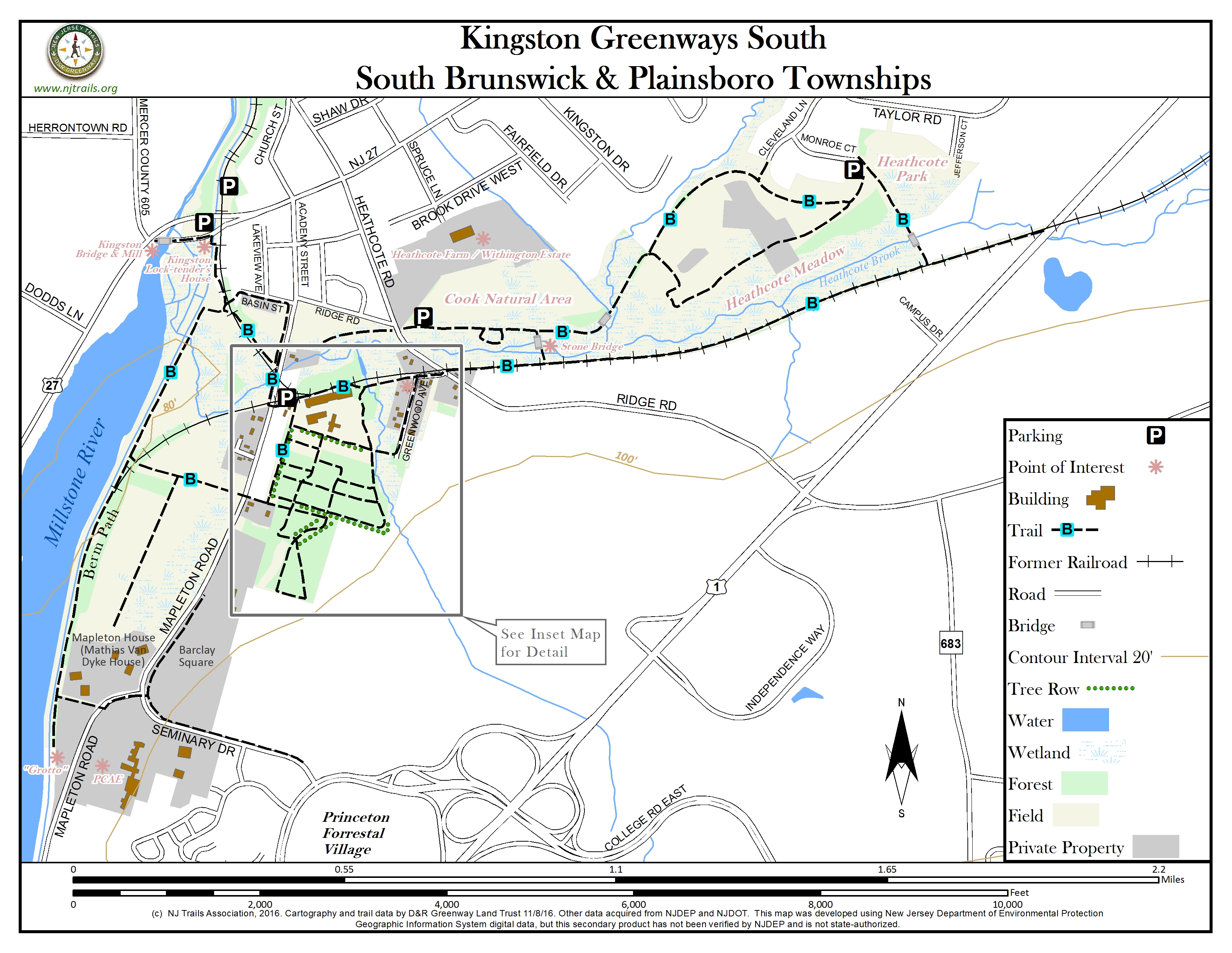
Kingston Greenways South
Princeton , NJ 08540


Last Updated: 07/02/2018
Overview of Selected Trail
Kingston Greenways South is part of the greenbelt surrounding the historic village of Kingston. Much of it was once part of the Princeton Nurseries Kingston Site. It is now a cultural landscape including buildings as well as open space. The area consists of over 400 acres generally south and east of the village, most of it open to the public. It has a wide variety of trails and points of interest with some of the trails linking to the D&R Canal towpath.
Along with views of various buildings of the former Princeton Nurseries, this preserve features a variety of tree rows, open fields, small streams and lakes, old stone walls, natural areas along stream corridors, and old growth pine and hardwood forests. The area is divided into several sections: The Mapleton Preserve (the core of the former Nurseries), the Cook Natural Area, Heathcote Meadow County Park, Heathcote Township Park, the former seed beds, parts of the Kingston Branch rail-trail and the D&R Canal berm path. Within the area are also several privateproperties with historic preservation easements, which contribute to the cultural landscape.
Note: Map is a two-page document with enlarged inset map on page 2.
-
-
Distance:
A total of about 8 miles of trails plus ½ mile of paved driveway/local roads.
Time:
Any length of time up to 4 hours or more.
Markings:
Only one trail is marked, but trails are generally obvious – see trail description.
Trail Usage:
Walking/hiking/biking. Dogs are permitted on leash.
Elevation:
Almost entirely flat terrain.
Difficulty:
Easy.
Parking:
General parking at the D&R Canal State Park Headquarters, 145 Mapleton Road. Parking is also available at the D&R Canal State Park Kingston Lock area, the Cook Natural Area and Heathcote Park (see map).
Tips:
The area is owned variously by the State of New Jersey, South Brunswick Township, Middlesex County and jointly by the State of New Jersey and South Brunswick Township. In addition there are several private parcels with historic preservation easements. A non-profit organization, Friends of Princeton Nursery Lands, maintains a website www.fpnl.org with additional information, as do the Kingston Historical Society www.khsnj.organd the Kingston Greenways Association www.kingstongreenways.org. The various groups also offer guided walks and talks about the area as well as work sessions from time to time.
Amenities:
There are two picnic tables at the D&R Canal State Park Headquarters area and several picnic tables at the Kingston Lock area. Several interpretive signs, mostly in the Headquarters area, relate to the former Princeton Nurseries. The Flemer Arboretum, which contains specimens of Princeton Nurseries cultivars, is adjacent to the Headquarters area. A Clivus Multrum compostable (barrier free) toilet is located adjacent to the Headquarters area.
Directions:
To the D. & R. Canal State Park headquarters area and adjacent parking:
a. From the south on Route 1:
Take Route 1 North to College Road West {Princeton Forrestal Village, College Road West} exit. From exit ramp continue onto College Road West. At the second traffic light continue straight [road becomes Seminary Drive]. Continue past the next traffic light [road becomes Mapleton Road] about 0.7 miles, and turn right into driveway {white Mapleton Preserve sign; brown D&R Canal State Park sign}. Continue (approximately 250 feet) to the parking area behind the (D&R Canal State Park headquarters) building.
b. From the north on Route 1:
Take Ridge Road exit heading towards the village of Kingston for approximately 1 mile – bear left on Ridge at the intersection of Ridge Road and Heathcote Brook Road (before the hill). At the stop sign, turn left onto Academy Street (Academy St. becomes Mapleton Rd). The Mapleton Preserve and the D&R Canal State Park headquarters are located at 145 Mapleton Road – approximately 0.2 miles from Ridge Road on the left side of the road.
Turn left into driveway {white Mapleton Preserve sign; brown D & R Canal State Park sign}. Continue (approximately 250 feet) to the parking area behind the (D&R Canal State Park headquarters) building.
c. From Route 27: Turn onto Academy Street at the traffic light in Kingston (across from the Kingston Cemetery). Academy Street bends slightly to the right and becomes Mapleton Road as it heads towards Route 1. The Mapleton Preserve and the D&R Canal State Park headquarters are located at 145 – approximately 0.3 miles from Rte. 27 on the left side of the road. Turn left into driveway {white Mapleton Preserve sign; brown D & R Canal State Park sign}. Continue (approximately 250 feet) to the parking area behind the (D&R Canal State Park headquarters) building.
The larger Building is the main D&R Canal State Park office; the small building next to the main office is the Education Building.
To the Cook Natural Area parking lot:
a. From Route 1:
Take Ridge Road exit heading towards the village of Kingston for approximately 1 mile. Just after the bridge over Heathcote Brook turn right into the Cook Natural Area parking lot.
b. From Route 27: Turn onto Heathcote Brook Road (traffic light) in Kingston; Heathcote Brook Road becomes Ridge Road at the bottom of the hill. Just after the stop sign turn left into the Cook Natural Area parking lot.
To the Heathcote Park parking lot:
a. From Route 1:
Take Raymond Road exit heading towards the village of Kingston for approximately 1 mile. Turn left onto Cleveland Lane and then left onto Monroe Court; parking area is at end of Monroe Court.
b. From Route 27: Turn onto Raymond Road (traffic light). Continue for approximately 0.5 mile. Turn right onto Cleveland Lane, then left onto Monroe Court to the parking area is at end of Monroe Court.
To the D. & R. Canal State Park Kingston Lock area parking lot:
a. From Princeton on Route 27:
After the River Road traffic light, cross the D & R Canal bridge and turn right 180 degrees onto Old Route 27. Turn right into the D. & R. Canal State Park Parking lot.
b. From New Brunswick on Route 27:
After the Academy Street traffic light, continue to the bottom of the hill and turn left and then immediately right onto Old Route 27. Turn right into the D. & R. Canal State Park Parking lot.
c. From Route 1: Take Ridge Road exit heading towards the village of Kingston for approximately 1 mile. Bear left on Ridge Road at the intersection of Ridge Road and Heathcote Brook Road (before the hill). At the stop sign, turn right onto Academy Street. Continue to Route 27 (traffic light); turn left onto Route 27, continue to the bottom of the hill, turn left and then immediately right onto Old Route 27. Turn right into the D. & R. Canal State Park Parking lot.
To the D. & R. Canal State Park Kingston Lock area and adjacent parking:
a. From the south on Route 1:
Take Route 1 North to College Road West {Princeton Forrestal Village, College Road West} exit. From exit ramp continue onto College Road West. At the second traffic light continue straight [Road becomes Seminary Drive]. Continue past the next traffic light [Road becomes Mapleton Road] about 1 mile to Route 27 (traffic light). Turn left on to route 27 south. At the bottom of the hill (before the concrete D&R Canal bridge) turn left and then immediately right; cross the wooden D&R canal bridge; the main parking area is a short distance to the right; another is a short distance to the left (behind the Lock-tender’s House.)
b. From the north on Route 1:
Take Ridge Road exit heading towards the village of Kingston for approximately 1 mile. Bear left on Ridge at the intersection of Ridge Road and Heathcote Brook Road (before the hill). At the stop sign, turn right onto Academy Street. Continue to the traffic light at Route 27, turn left on to route 27 south, and at the bottom of the hill (before the concrete D&R Canal bridge) turn left and then immediately right. Cross the wooden D&R canal bridge. The main parking area is a short distance to the right; another is a short distance to the left (behind the Lock-tender’s House.)
c. From the north on Route 27: Proceed past the traffic light at Academy Street/ Church Street on Route 27 South to the bottom of the hill (before the concrete D&R Canal bridge) turn left and the immediately right; cross the wooden D&R canal bridge; the main parking area is a short distance to the right; another is a short distance to the left (behind the Lock-tender’s House.)
d. From the south on Route 27: Proceed on Route 27 past the traffic light at River Road, across the Millstone River and (concrete) D&R Canal bridges; immediately turn right 180 degrees onto Old Route 27 South. Cross the wooden D&R canal bridge. The main parking area is a short distance to the right; another is a short distance to the left (behind the Lock-tender’s House.)
-
The only marked trail is the Blue Trail. It has two parts, both of which begin at the kiosk at the D&R Canal State Park headquarters/ Mapleton Preserve parking area. Nearby are several interpretive signs describing the history of the former Princeton Nurseries – once the largest commercial nursery in the world. To the east of the headquarters, and in 2018 behind a chain-link fence, are the massive former bare-root storage warehouses, for which there are plans for future adaptive use.
The Blue Trail West Loop
Starting at the kiosk at the headquarters, head south. On the right is the Flemer Arboretum, which contains specimens of some of the many tree cultivars developed on the site; on the left is an evergreen tree-row – one of the so-called “windrows” that provided windbreaks for the fields. A network of paths, mowed former nursery roads, lies east of the “windrow.
The Blue Trail turns west before the former barn and stable (on private property), and continues west, crossing Mapleton Road. It passes through an area known as the “Flats” or “Seedbeds,” which contains a splendid row of Japanese Maples, and ends at the D&R Canal “berm path” (i.e. the path on the opposite side of the canal from the “towpath”). The Blue Trail runs north along the canal.
At this point one can also take a side trip south to the “Grotto,” the contemplative area of the former St Joseph’s Seminary. From the “grotto,” steps lead to Mapleton Road, from which one can see the impressive former Seminary buildings – now the home of the Princeton Center for the Arts and Education (PCAE.)
The Blue Trail continues along the D&R canal on its “berm path” to the canal’s Kingston Turning Basin.
From the basin a side trail leads north to the Kingston Lock, across the sluice gates to the towpath and to the former Lock-tender’s House and Toll House; beyond the Lock-tender’s House, one can turn west to the historic 1798 quadruple stone arch bridge and the Kingston Mill, built in 1893 on the site of two earlier mills. The mill is now a private residence.
The Blue Trail turns east and continues to Mapleton Road and then runs south, along Mapleton Road, then east on the main driveway (with signs for the Mapleton Preserve and the D&R Canal State Park) and back to the D&R Canal State Park headquarters building.
The Blue Trail East Loop
Also starting at the kiosk at the headquarters, head north towards the small building ahead, once PN’s blacksmith shop, now the Education Building. Then head east toward the fence enclosing the massive former bare-root storage warehouses, continue a short distance and turn right onto a former nursery road. On the right are the former bare-root storage buildings. Continue east onto Railroad Avenue, past some of the renovated former nursery employee houses. Continue to Ridge Road, make a slight jog to the left and continue east on the former bed of the Camden & Amboy Railroad for about an eighth of a mile. Turn left onto the “bridge trail,” which crosses two small bridges. The second, with a stone arch, was reconstructed from an earlier bridge on Ridge Road. A short distance beyond, the Blue Trail joins the Cook Preserve Trail, from which one can look over the fields to the north. Across the fields, at the top of a plateau is the grand house of the Withington Estate (Heathcote Farm). To the right (east), the Blue Trail joins the Heathcote Meadows Preserve loop trail, which soon branches. One can continue northeast along Carter Brook and then southeast, or head southeast at the branch. Both branches of the loop join and continue northeast into Heathcote Township Park. The route then heads south through a wooded area to the Kingston Branch Railroad Trail. Turn right to get back to Ridge Road, cross Ridge Road, make a jog to the left and return to Railroad Avenue and the headquarters area.
The Mapleton Preserve Loop
Although unmarked, a popular trail route is to proceed east from the kiosk (at the headquarters). On the right is a row of Princeton Sentry Ginkgo trees; on the left one passes the former Propagation House with attached greenhouses and stack (now behind a chain-link fence and awaiting restoration). At the end of the Ginkgo row turn south; after about 0.2 mile the path turns west. Continue about .1 mile and turn left for a short distance, then right; there is an interpretive sign at the site of the former PN dormitory area. Continue past the former nursery barn (now private) to a junction with the Blue trail. Go right (north), with an evergreen (Chamaecyparis)windrow on the right, broken by mown paths leading to the fields to the east. Follow the Blue Trail back to the headquarters area. Within the Preserve Loop there are numerous mowed paths (former nursery roads), which cut across the area and afford alternate paths.
The Cook Preserve Trail
From the Cook Natural Area Parking area off Ridge Road: The trail heads east. There is a small loop around a small pond to the right of the trail. From the Cook Trail one can look over the fields on the north (across the fields, at the top of a plateau is the grand house of the Withington Estate (Heathcote Farm). The trail joins the East Loop of the Blue Trail, which in turn joins with Heathcote Meadows Preserve loop trail, part of the Blue Trail’s East Loop.
Kingston Branch Rail Trail:
The trail generally follows the former roadbed of the Camden & Amboy Railroad (later taken over by the Pennsylvania RR). The east end of the trail is opposite the Kingston Lock of the D&R Canal, where the Kingston RR Station was relocated in 1864. The trail goes past the Kingston turning basin and joins a section of the Blue Trail’s West Loop and roughly parallels the former RR roadbed; it makes a jog to Mapleton Road and then heads east continuing to roughly parallel the former RR bed, continues on Railroad Avenue, making a short jog to the left before crossing Ridge Road and continuing on the former RR bed. There are two trails branching off to the left – one to the Cook Preserve and the other to Heathcote Park; the trail ends at Route 1.
Heathcote Meadows Preserve Trail:
Access is available from the Parking area at South Brunswick Township’s Heathcote Park as well as from the Cook Preserve Trail. The trail is part of the East Loop of the Blue Trail. Heathcote Meadows Preserve, which “provides a glimpse of the rich farming history of the area” is managed by Middlesex County to provide habitat for native flora and fauna.
D & R Canal Towpath
The D & R Canal State Park and its towpath is part of the Kingston area trail system and is accessible from the parking area at the Kingston Lock and the Blue Trail West Loop.
D & R Canal Berm-path
The D & R Canal State Park and its berm-path is part of the Kingston area trail system; the berm-path includes part of the Blue Trail West Loop from which it is accessible. The berm path is also accessible from the parking area at the Kingston Lock and the Kingston Branch Rail Trail.
-
Deer, foxes and smaller mammals are present. Along the D&R Canal berm-path beavers can occasionally be seen. The area is a cultural landscape, which, although it includes natural areas, particularly along streams, is largely the result of agricultural and horticultural activities. Princeton Nurseries developed numerous cultivars from both native and non-native species. A group of these cultivars can be found in the ‘Flemer Arboretum’ located just south of the entrance drive; a list of many of the Princeton Nurseries cultivars can be found on the interpretive sign closest to the Arboretum.
Rows of evergreens, locally called “windrows,” were planted to provide windbreaks. Also notable is a row of Ginkgoes along the extension of the entrance drive and the rows of London Plane and cherry trees that line Mapleton Road.
In its 85-year history here, Princeton Nurseries introduced important plant varieties including the legendary, disease-resistant Princeton Elm, the ‘October Glory’ Maple, and the ‘Snow Queen’ Hydrangea, many of which still grow on former Princeton Nurseries property.
US Plant Patents associated with Princeton Nurseries
- PP1515 Gleditsia tricanthos ‘Shademaster’ a.k.a. ‘Princeton’(1956)
- PP3092 Amelanchier x ‘Cumulus‘ (1972)
- PP4119 Campsis radicans “Crimson Trumpet” (1977)
- PP4458 Hydrangea quercifolia “Snow Queen” (1979)
- PP4540 Prunus subhirtella “Pink Cloud” (1980)
- PP4632 Flowering Crab Apple Tree (Malus hupehensis x M atrosanguinea) “StrawberryParfait” (1981)
- PP5080 Zelkova Serrata Tree “Green Vase”(1983)
- PP5524 Sophora japonica Princeton Upright(1985)
- PP5730 Flowering Cherry Tree (Prunus yedoensis “Afterglow”(1986)
- PP5800 Flowering Crab Apple Tree (Malus “Bridal Bouquet”)(1986)
- PP6727 Princeton Gold (Acer platanoides)(1989)
- PP7072 Amelanchier canadensis “White Pillar”(1988)
- PP7147 Malus hupenhensis named ‘Cardinal’(1990)
- PP7203 Amelanchier laevis “Majestic” (1990)
- PP7217 Acer palmatum “Crimson Prince” (1990)
- PP9093 Quercus palustris ‘Pringreen’(1995)
- PP10481 Cletra lanifolia Plant Named ‘September Beauty’ (1998)
- PP10557 Maackia amurensis Plant Named ‘Starburst’(1998)
- PP10989 Prunus sargentii Plant named ‘Princeton Snowcloud’(1999)
- PP11055 Forsythia Hybrid Plant Named ‘Princeton Gold’ (1999)
Lichens and mushrooms can be found in both the natural and formerly cultivated areas.
The area north of Ridge Road was largely a dairy farm, although the area along Heathcote Brook is natural.
Do you have information about this trail?
Click Here to contribute.
-
The historic village of Kingston is surrounded by the Kingston Green Belt, which preserves a significant part of the historic rural agricultural context of the village. Most of the Green Belt is accessible to the public and is linked with numerous trails, which offer recreational opportunities and a view of the area’s historic resources. The Green Belt includes the following areas.
Former Princeton Nurseries Kingston Site
The former nursery site includes Mapleton Preserve and adjacent DEP and South Brunswick Township land. These together cover about 240 acres, of which 53 are the Mapleton Preserve and over 220 are open to the public.
Princeton Nurseries (PN) was once the largest commercial nursery in the United States. It was established in 1913 by William Flemer, Sr., when the first farm was purchased. Originally it was a branch of the Flemer family’s F&F Nursery in Springfield, NJ, where development had made land for expansion expensive and scarce. The Flemers made an extensive search in the eastern US and chose the Kingston site because of its rich soil, its climate, and its location, central to New York, Washington, DC and other metropolitan areas, with access to the Rocky Hill branch of the Pennsylvania Railroad. It was also adjacent to the Delaware and Raritan Canal. Within the next few years three other farms were acquired. Subsequently, many other farms were acquired and others leased by PN.
Princeton Nurseries remained a family-run organization at this site for 82 years and, at its peak, farmed over 1,500 acres of land in South Brunswick, Plainsboro, Franklin and West Windsor, employing over 300 people. It acquired a national and international reputation for excellence and developed and introduced many important plant varieties, including the legendary, disease-resistant Princeton Elm (specimens line Washington Road forming the National Register Washington Road Elm Allée. Its list of patented tree varieties reads like a “Who’s Who” of the horticultural world! William Flemer III, a world- famous plantsman who took over nursery production in 1945, was the 2001 recipient of the Royal Horticultural Society’s prestigious Veitch Memorial Medal.
The Flemer family also developed many innovative horticultural practices and technologies, fabricating prototypes for many of their tools and equipment in Nursery workshops on the site. The operation was self-contained, with a blacksmith shop, a mechanics’ shop and boilers for the greenhouses; there were stables for draft horses and subsequent machinery. PN even had its own water company (which also supplied the village of Kingston with water for many years). PN provided much of the housing for its employees.
In the 1960s, as development and land values in the area increased, PN sold some of its land and purchased substantially more acreage in the Allentown (NJ) area where land was less expensive.
When Princeton Nurseries left Kingston in 1995, more than 400 acres of the former nursery lands remained undeveloped in South Brunswick and Plainsboro. Over 240 acres (and many of the historic Princeton Nurseries structures) were preserved as a cultural landscape by the State of New Jersey and South Brunswick Township in 2005, after close to ten years of negotiations.
The Princeton Nurseries Historic District, which includes numerous contributing rural vernacular houses and out-buildings, was identified in a 1979 historic sites inventory. The inventory noted, on its [NJ] Office of Historic Preservation form, under Significance
“The district is notable for the remarkably consistent picture it presents of a specialized agricultural practice, little changed in appearance and basic methodology since the early 20thcentury. Princeton Nurseries was founded in 1911,and has grown to be the largest wholesale nursery in the world. Combined with Carnegie Lake and the Delaware and Raritan Canal on the western boundary of the district, the nursery fields provide valuable green “breathing space” in an area rapidly undergoing transformation to multi-unit housing. At least three of the more significant houses are related to the 18thcentury development of the area, but the district’s greatest significance lies in the rare environmental and aesthetic experience it creates.”
In 2008 the area was listed on the NJ State Register of Historic Places.
The Mapleton Preserve – the historic heart of the former Princeton Nurseries property – is an approximately 53-acre site, jointly owned by South Brunswick Township and the State of New Jersey. Adjacent to the Preserve is the former historical Sales and Administrative Building for Princeton Nurseries, which is one of several Princeton Nurseries buildings renovated by the locally noted Princeton Architect, Rolf W. Bauhan. This building has been restored to become the main offices for the Delaware and Raritan Canal State Park. The adjacent education building, once the blacksmith shop and later the Nurseries’ Safety and Education Building, is now used for natural and historic programming for the public. Two large groups of bare-root storage buildings (once used to store and sort dormant trees for shipment in the spring), a propagation house, and several greenhouses are nearby. These and the Propagation House, topped by a brick-red smokestack proudly bearing the initials “PN,” are enclosed by a chain-link fence and in need of substantial rehabilitation; however there are plans to rehabilitate/ restore these buildings.
Many of the preserved nursery fields, some with tree rows, now serve as passive open space; the former nursery roads now serve as pathways for public use. The landscape and nursery trees that remain on the site provide an important record of the history of Princeton Nurseries. A cultural landscape report has been completed with the aid of a NJ Historic Trust grant. The report recommended ways to maintain the area’s historic character for interpretation and enjoyment.
The larger cultural landscape includes numerous horticultural areas, former farm fields and specialized nursery buildings. Eighteen of the forty-five homes that housed nursery workers and Flemer family dwellings have been preserved and restored as private residences with historic preservation easements. Hundreds of specimen trees and tree rows of nursery stock remain on the property, providing a valuable (though overgrown) record of Princeton Nurseries introductions, as well as refuge for breeding and migratory birds.
In addition, the cultural landscape includes a portion of Mapleton Road, a scenic colonial road — lined with trees by the Flemer family — that bisects the nursery property. It was shown on the 1745 Dalley Map and is an integral part of the landscape, which also includes a portion of Ridge Road, another colonial road, along which George Washington led Colonial troops to the Battle of Monmouth.
These scenic and historic resources have the potential to serve as an outstanding interpretive center for horticultural, historic and natural education, for the benefit of the people of the region, New Jersey, and beyond. Mapleton Preserve — the historic heart of Princeton Nurseries — is increasingly utilized as a passive recreational resource. Vigorous programming at the site has been developed by the Delaware and Raritan Canal State Park and other local non-profit groups – the Kingston Historical Society, Kingston Greenways Association and especially Friends of Princeton Nursery Lands. Horticultural advances developed at Princeton Nurseries under the Flemer family are highlighted, and particular emphasis is placed upon encouraging public awareness and understanding of the historic significance of the site as well as a passive recreational resource.
Cook Natural Area
This area has two parts–one a natural area and the other maintained as a field and farmed for hay. The Area was donated to the State of New Jersey by Grace Cook in the 1970s to be “maintained to promote the enjoyment of natural things including trees, birds, wildlife and water; to educate the public as to the importance of ecology to all life including man’s; and to nurture plants and animals for agricultural, horticultural, scientific and recreational purposes.”Overlooking the area is the large stone house of Heathcote Farm. On property acquired by the State from Issac Withington, the building was originally constructed to be a State House of Refuge for disturbed boys. That project was abandoned, however, when the State ran out of funding and the unfinished building was bought back by Withington, who converted it into a grand house.
Kingston Branch Rail Trail
Largely on the former roadbed of the original Camden & Amboy Railroad Branch Line (1838), the line extended along the D&R Canal from Trenton to just south of the village of Kingston, where the line turned northeast to Deans Pond and from there to New Brunswick. In 1864 the line from Trenton to Deans Pond was straightened and today is part of the NE rail corridor. The section from Kingston, realigned to Monmouth Junction at the east end and extended largely along the D&R Canal to Rocky Hill, later became part of the Pennsylvania Railroad. It remained as the Kingston Branch until the 1970s. Its former roadbed is now a public trail.
D&R Canal
The construction of the D&R Canal (1832) began at Kingston. Today the Kingston section of the D&R Canal State Park is a key part of the Kingston Green Belt, and towpath and berm paths form part of its trail system as well as linking to other historic and natural resources. The Kingston Lock area includes a lock-tender’s house, toll house, bridge and basin as well as Lock #8. Nearby is the 1798 quadruple arch stone bridge, which replaced an earlier one dismantled by Washington to delay the pursuit of the British after the Battle of Princeton, and the 1893 Kingston Mill (now a private residence), the third mill on the site. Much of the towpath runs along Lake Carnegie (1905); the dam creating the Lake, which provided Princeton University’s crew a proper course, is in Kingston. Part of the berm path is over the former roadbed of the original (1838-1864) Camden & Amboy Railroad Branch Line.
Heathcote Meadow Preserve
Approximately 89 acres.
A Middlesex County open space preserve, acquired in 1998, was one of the first areas acquired under the Middlesex County Space Recreation and Farmland and Historic Preservation Act. It is a critical part of the Kingston Green Belt and links the Cook Natural Area and the South Brunswick Township Heathcote Park. There is a loop trail through former pasture land and natural areas which links to trails in adjacent areas. The preserve offers a glimpse into the rich farming history of the area and provides stream protection for Heathcote Brook and Carter Brook while providing wonderful opportunities for hiking, walking and wildlife viewing.
Heathcote Park
Approximately 19 acres, which includes some active recreation areas (for tennis and baseball).
A South Brunswick Township park, which was the result of the adjacent residential development; it includes tennis courts and ball fields as well as natural areas and a trail which connects the Heathcote meadow trails to the Kingston Branch railroad trail through a natural area.
Village of Kingston
Kingston is a unique community, which began in 1683 with Henry Greenland’s settling along the rude road connecting the fall lines of the Delaware and Raritan Rivers near the crossing, then merely a ford, of the Millstone River. Greenland’s house was also a tavern in which, in 1686/ 7, was signed the Keith Line Agreement which delineated East and West Jersey. As traffic grew, houses, taverns and shops were built along the road on the plateau overlooking the river crossing. By 1723, when the first Kingston Presbyterian Church was built, these buildings had become the village of Kingston, sometimes called King’s Town.
Today what was historically Kingston forms a small part of three counties (Somerset, Middlesex and Mercer) and four townships: Franklin, Plainsboro, South Brunswick, and Princeton. The historical village itself is divided by Route 27, once known as the King’s Highway, between Franklin and South Brunswick; the Kingston Mill District (which includes Henry Greenland’s house and what remains of his farm, the mill, bridge and several other historic houses) lies largely in Princeton Township; the Princeton Nurseries historic district, a significant part of the historic rural agricultural area which provides the historical context of the village as well as its buffer, lies in both South Brunswick and Plainsboro Townships. Mapleton Road is already indicated on John Dalley’s map of 1745.
During the American Revolution, General George Washington and his troops passed through Kingston after the Battle of Princeton in 1777 and had the “conference on horseback” in the Kingston Cemetery, where the decision was made to withdraw to Morristown rather than proceed to New Brunswick. In 1778 Washington and his troops again passed through Kingston on the way to the Battle of Monmouth. Throughout the war the King’s Highway was a major route for both British and American supplies and personnel. After Yorktown, Washington spent several months, during the Congress’s meeting in Princeton’s Nassau Hall, and at Rockingham, now a State Historic Site, he wrote his Final Orders to the Army.
Delaware & Raritan Canal State Park
The Kingston Basin area includes a lock, lock-tender’s house, and toll house/ telegraph office as well as the basin itself. The lock-tender’s House—open to the public 10 am-5 pm on weekends and some holidays from April through November—contains small exhibits on the canal and local history.
Do you have information about this trail?
Click Here to contribute.
-
Photos
Videos
