Middlesex
Monroe Township
Jamesburg Park Conservation Area
Monroe Township, NJ 08831


Last Updated: 05/07/2022
Overview of Selected Trail
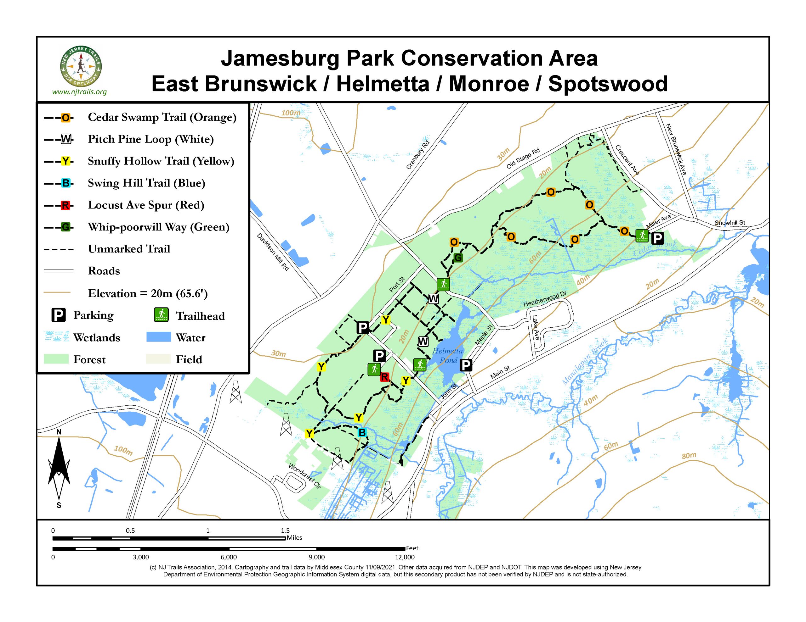
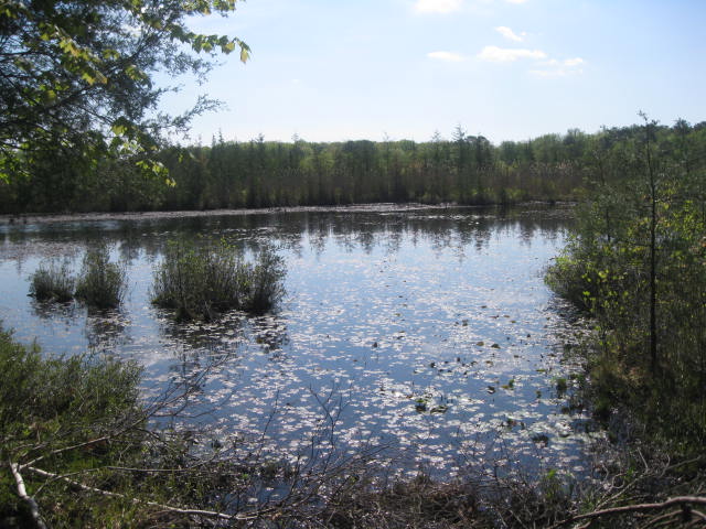
The Jamesburg Park Conservation Area is over 1400 acres of pine barrens forest that lies within the Spotswood Outlier – the northernmost area of New Jersey Pinelands habitat, while Helmetta Pond and adjacent wetlands provide bog habitat for carnivorous plants. It is great for passive recreation activities such as hiking, photography and nature study, with ample wildlife viewing opportunities. Launch your boat from the ramp at Helme Park and enjoy the self-guided, interpretive tour of this 5-acre pond. It is owned and maintained by the Middlesex County Office of Parks and Recreation.
.
-
-
Distance:
A total of 8 miles of trails that include:
Locust Avenue Spur (Red Blazes): 0.13 miles; connects Locust Avenue parking area with Snuffy Hollow Trail (Yellow Blazes); 5 minutes to walk at a leisurely pace.
Snuffy Hollow Trail (Yellow Blazes): 2.45 miles; 60 minutes to walk at a leisurely pace. Flat and sandy.
Pitch Pine Loop (White Blazes): 1.61 miles; 40 minutes to walk at a leisurely pace. Flat and mostly sandy, with some bog walks in wet areas and many views of Helmetta Pond. Bird blind and lookouts along the way.
Whip-poorwill Way (Green Blazes): 0.25 miles; connector between Cedar Swamp Trail (Orange Blazes) segments; 7 minutes to walk at a leisurely pace with a small hill.
Swing Hill Trail (Blue Blazes): 0.61 miles; 15 minutes to walk at a leisurely pace. Flat.
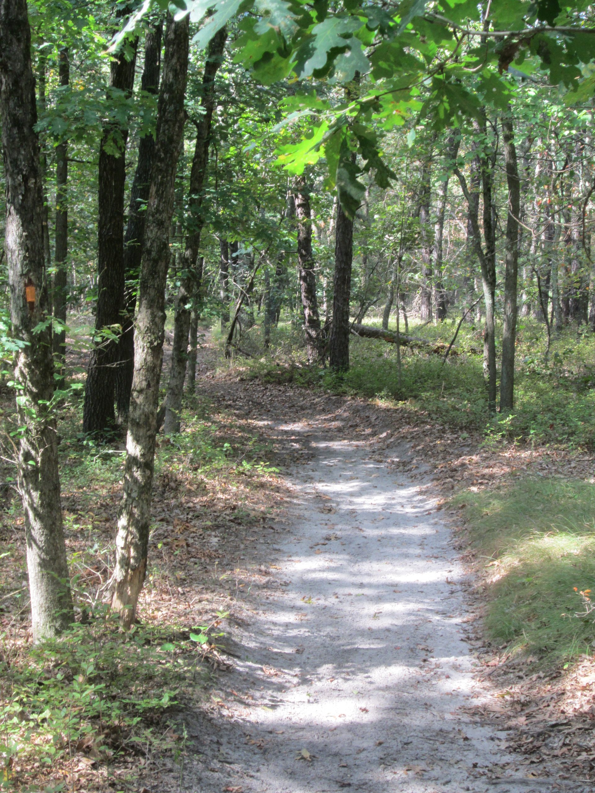
Cedar Swamp Trail (Orange Blazes): 3.03 miles; 1 hour 30 minutes to walk at a leisurely pace. Flat with some bog walks in wet areas.
Time:
Any length of time from a short ten-minute walk to a few hours
Markings:
Trails are marked by various color blazes.
Trail Usage:
Hiking and pets on leash.
Elevation:
Level hiking
Difficulty:
Easy
Parking:
Parking is available at gravel lots on Locust Avenue and at the end of Miller Avenue. There is a larger gravel parking area at Helme Mill Park on Maple Street with a playground, portable toilet, and access to Helmetta Pond.
Tips:
Note: This park is relatively secluded, the chances of seeing other hikers are low.
The trails are open from sunrise to sunset. All dogs must be on leashes. Please feel free to pick up any litter you find.
Trails are not suitable for bicycles or horses.
Trails are mostly dry after a day of rain. Some areas would be undesirable to walk during rain, because of slippery bog-walks.
For assistance, call Park Ranger Unit at 732-745-3800.
Amenities:
Map boxes are available at the Locust Avenue and Miller Avenue trailheads. Helmetta Mill Park on Maple Street has a playground, portable toilet, fishing pier, and boat ramp access to Helmetta Pond. Interpretive sign and brochures for the self-guided, interpretive paddling trail are available at this location as well.
Directions:
From New Brunswick:
Locust Avenue Trailhead:
Take the exit for Rt. 130 South off Rt.1. At light after Middlesex County Offices & Correctional Center, make left onto Davidson Mill Road and follow to the traffic light at the end. Turn left onto County Route 535 North (Cranbury-South River Road) and make a right at the first traffic light onto Helmetta Boulevard. Take the first right onto Port Street and follow around the bend, where it turns into Washington Avenue. Locust Avenue is the first right. Parking area up on the right.
Miller Avenue Trailhead:
Take the exit for Rt. 130 South off Rt.1. At light after Middlesex County Offices & Correctional Center, make left onto Davidson Mill Road and follow to the traffic light at the end. Turn left onto County Route 535 North (Cranbury-South River Road) and make a right at the first traffic light onto Helmetta Boulevard. Take the first left onto Old Stage Road and follow 1.5 miles, making your first right onto Crescent Avenue. Continue 0.75 miles to Miller Avenue on the right and follow to parking area at the end.
Helme Mill Park Trailhead (Maple Street):
Take the exit for Rt. 130 South off Rt.1. At light after Middlesex County Offices & Correctional Center, make left onto Davidson Mill Road and follow to the traffic light at the end. Turn left onto County Route 535 North (Cranbury-South River Road) and make a right at the first traffic light onto Helmetta Boulevard. Take the second right onto Maple Street. Parking area 0.3 miles on the right.
From New Jersey Turnpike:
Locust Avenue Trailhead:
Take Exit 8A. Follow signs for County Route 535 North (Cranbury-South River Road). Take CR 535 North approximately 4.1 miles and turn right onto Helmetta Boulevard. Take the first right onto Port Street and follow around the bend, where it turns into Washington Avenue. Locust Avenue is the first right. Parking area up on the right.
Miller Avenue Trailhead:
Take Exit 8A. Follow signs for County Route 535 North (Cranbury-South River Road). Take CR 535 North approximately 4.1 miles and turn right onto Helmetta Boulevard. Take the first left onto Old Stage Road and follow 1.5 miles, making your first right onto Crescent Avenue. Continue 0.75 miles to Miller Avenue on the right and follow to parking area at the end.
Helme Park Trailhead (Maple Street):
Take Exit 8A. Follow signs for County Route 535 North (Cranbury-South River Road). Take CR 535 North approximately 4.1 miles and turn right onto Helmetta Boulevard. Take the second right onto Maple Street. Parking area 0.3 miles on the right.
-
All trails are at least 4 feet wide with an 8-foot clearance and marked with colored blazes.
Locust Avenue Spur (Red): Starting from the Locust Avenue Parking Area
Turn right out of the parking area and follow Locust Avenue to the trailhead on the left, marked with a large wooden arch. After passing under the arch, take notice of the old sidewalks and curbing on the left-hand side that date back to the early 1900’s. Follow the trail at a slight, downhill incline where it connects to the Snuffy Hollow Trail at 0.13 miles.
Snuffy Hollow Trail (Yellow): From the Junction with the Locust Avenue Spur (Red)
From the junction with the Locust Avenue Spur (Red), trail to the left continues 0.2 miles, ending at Washington Road, with a connection across the street to the Pitch Pine Loop (White).
Turning right at the intersection with the Locust Avenue Spur, follow the yellow blazes through the forest. At 0.1 miles, pass yellow blazed trail on your left (this will take you to Washington Road). Continue STRAIGHT past this turn as the trail meanders through upland pitch pine forest, coming to an intersection at 0.6 miles. Turn left and continue following the yellow blazes. In about 300 feet, the trail will turn right. Trail straight ahead continues for 0.25 miles, reaching the power lines and junction with the Swing Hill Trail (Blue). Turning right, the trail ascends a small hill and the forest changes from pitch pine to deciduous hardwoods. Continue following the yellow blazes, arriving at the corner of Washington Avenue and Port Street at 1.6 miles. Cross over to the opposite corner and the trail re-enters the woods. PLEASE USE CAUTION WHEN CROSSING THE ROAD. The trail continues again through pitch-pine forest, crosses Johnston Blvd (paved), ending at the junction with the Pitch Pine Loop (White) at 1.9 miles.
Pitch Pine Loop (White): Starting from Washington Avenue, across from the end of Snuffy Hollow Trail (Yellow)
Leaving Washington Avenue, the trail roughly parallels Helmetta Pond on the right. At 0.15 miles, a short spur on the right will lead you to a viewing spot of the pond. Continue following the white blazes as the trail bends to the left. At 0.4 miles you will arrive at a 4-way way intersection. Trail to the right leads to another viewpoint of Helmetta Pond, adding 0.125 miles. Continue straight to another intersection at 0.5 miles. Trail to the right leads to a bird blind with views of Helmetta Pond and Atlantic White Cedar swamp, adding .08 miles to your hike. Turn left and continue following the white blazes. At 0.625 miles, white blazes to the right lead 0.125 miles to Helmetta Blvd and the start of the Cedar Swamp Trail (Orange). Continue straight to a left turn at 0.75 miles. (Trail straight ahead leads another 0.03 miles to Port Street). Turn left and continue to junction with Snuffy Hollow Trail (Yellow) at 0.90 miles. Turn left again and follow white blazes, arriving back at the 4-way intersection at 1.2 miles. Turn right and follow back to Washington Avenue.
Whip-poorwill Way (Green): This trail is a shortcut connecting the Cedar Swamp Trail (Orange). Taking Whip-poorwill Way removes about 0.3 miles off the Cedar Swamp Trail (Orange). Leaving the Cedar Swamp Trail (Orange), follow the green blazes up a small hill and then down again, arrive back at the Cedar Swamp Trail (Orange) at 0.25 miles.
Swing Hill Trail (Blue): Starting at power lines, near the end of the Snuffy Hollow Trail (Yellow).
This trail loops around the base of a small hill traditionally named by the locals as “Swing Hill”. There are several side trails, so be sure to follow blue trail blazes. Beginning at the power lines near the junction with the Snuffy Hollow Trail (yellow), the trail wanders along the base of Swing Hill, to the right. The Trail passes the old Buckelew cranberry bogs on the left at 0.45 miles, ending at the power lines at 0.61 miles.
Cedar Swamp Trail (Orange): From the intersection of the Pitch Pine Loop (White) and Helmetta Boulevard.
This trail is the longest at Jamesburg Park Conservation Area, traversing the eastern side of the park. Carefully cross Helmetta Boulevard. PLEASE USE CAUTION WHEN CROSSING THE ROAD. Follow the orange blazes to the junction with Whip-poorwill Way (Green) on the right at 0.125 miles. Continue straight, passing the junction with the other end of Whip-poorwill Way (Green) at 0.425 miles and arriving at a fork in the Cedar Swamp Trail at 0.85 miles. Continue straight, following the orange blazes through pitch pine forest, arriving at an intersection at 1.4 miles. Unmarked trail to the left leads to Old Stage Road. Turn right and continue following orange blazes to a fork at 1.8 miles. Trail straight ahead leads to parking area at Miller Road in another 0.375 miles. Turn right as the trail descends from the pitch pine forest into much wetter forest. The trail will cross a large ditch on a bridge (Built and installed by Middlesex County Vo-Tech students) and ascend slightly back into pitch pine habitat, arriving at an intersection at 2.65 miles. Turn left and follow back to Helmetta Blvd.
-
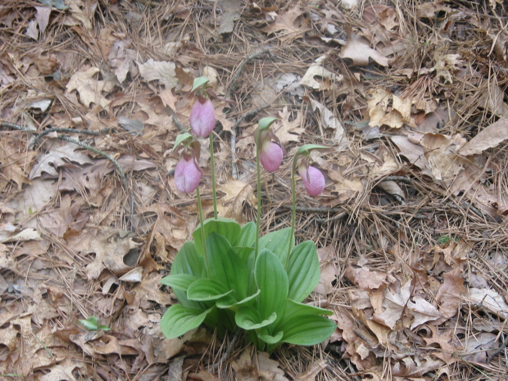
Jamesburg Park Conservation Area lies within the Spotswood Outlier—the northernmost area of New Jersey Pine Barrens habitat. Along the several miles of trails you can find pitch pine trees, blueberries, huckleberries and post oaks, species that are typical for a Pine Barren. The wetlands protect Atlantic white cedar trees and carnivorous pitcher plants. Several endangered and threatened species of plants and animals have been observed in this preserved open space, more than 130 species of birds have been observed here.
Do you have information about this trail?
Click Here to contribute.
-
Jamesburg Park Conservation area was one of the first lands acquired by Middlesex County using the Green Acres Funding for open space protection in the early 1970’s. Jamesburg Park would have been very different if the proposal to develop the town further had come to fruition. In the early 20th century, visitors were brought by train from New York to enjoy Saturday night dances and purchase land in the countryside of New Jersey. You can still find sidewalks in the woods showing where the streets were meant to run. Cranberry bogs covered some of the wetland areas, and the waters from Jamesburg Park Conservation Area were used by the nearby Helmetta Snuff mill.
Do you have information about this trail?
Click Here to contribute.
-
Photos
Videos
