Middlesex
North Brunswick Township
Ireland Brook Conservation Area
North Brunswick Township, NJ 08902


Last Updated: 05/14/2022
Overview of Selected Trail
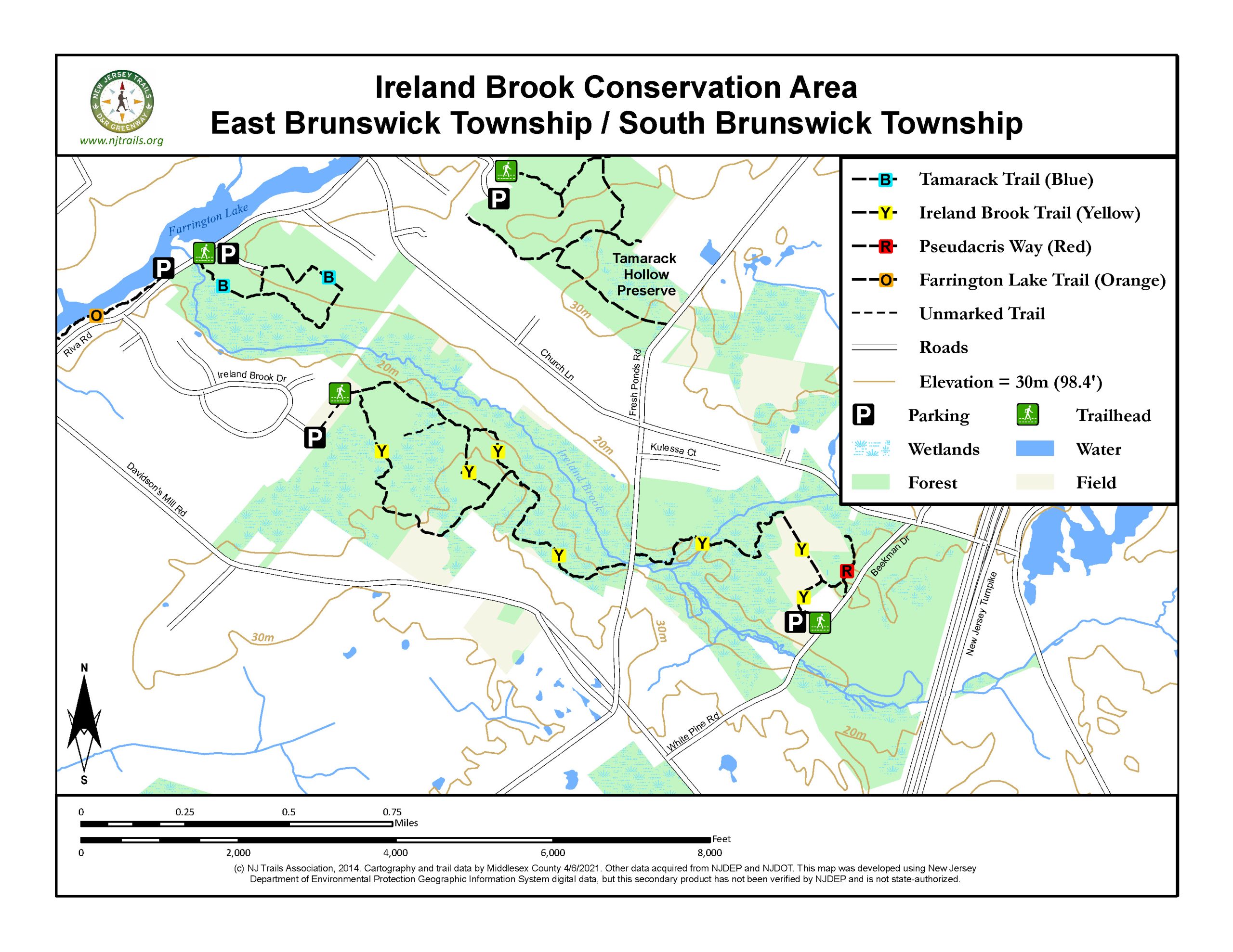
Ireland Brook Conservation Area spans 532 acres of meadows, forests, and floodplains that provide protection to the Ireland Brook, a major tributary of Farrington Lake. It is great for passive recreation activities such as hiking, photography, and nature study. The combination of upland habitat and riparian vegetation along the Ireland Brook make it an ideal area for wildlife viewing. It is owned and maintained by the Middlesex County Office of Parks and Recreation.
-
-
Distance:
A total of 5 miles of trails that include:
Ireland brook trail (Yellow Blazes): 2.9 miles; 2 hours to walk at a leisurely pace; Mostly flat with a few short inclines.
Forest Brook Trail (Blue Blazes): 0.83 miles; 25 minutes to walk at a leisurely pace; Flat
Pseudacris Way (Red Blazes): 0.2 miles; 10 minutes to walk at a leisurely pace; Flat
Farrington Lake Trail (Orange Blazes): 1.1 miles; 40 minutes to walk at a leisurely pace; Mostly flat with some elevation and stone staircases.
Time:
Any length of time from a short ten-minute walk to a few hours.
Markings:
Trails are marked by various color blazes.
Trail Usage:
Hiking and dogs lon leash.
Elevation:
Level hiking with a few short inclines.
Difficulty:
Easy
Parking:
Parking is available in gravel lots off Riva Avenue, Parkview Court off Ireland Brook Drive, and Beekman Drive.
Tips:
This Park is relatively secluded, the chances of seeing other hikers are low.
The trails are open from sunrise to sunset. All dogs must be on leashes. Please feel free to pick up any litter you find.
Trails are not suitable for bicycles or horses.
Trails are mostly dry after a day of rain. Some areas would be undesirable to walk during rain because of slippery rocks and bog-walks.
For assistance, Call Park Ranger Unit at 732-745-3800.
Amenities:
A kiosk is located beyond the gate at the Riva Avenue Trailhead and at the far end of the field from the Ireland Brook Drive Trailhead. Maps are available at the kiosks. A map box is also available in the parking area of the Beekman Drive trailhead.
Directions:
From New Brunswick:
Riva Avenue Trailhead:
Take the exit for Rt. 130 South off Rt.1. At light after Middlesex County Offices & Correctional Center, make left onto Davidson Mill Road. Make first left onto Riva Avenue and follow for 0.65 miles. Parking area will be on the right, shortly after crossing over the Ireland Brook.
Ireland Brook Drive Trailhead:
Take the exit for Rt. 130 South off Rt.1. At light after Middlesex County Offices & Correctional Center, make left onto Davidson Mill Road. Make first left onto Riva Avenue and first right onto Ireland Brook Drive. Follow Ireland Brook Drive up to Parkview Court on the left. Parking area will be on the left.
Beekman Drive Trailhead:
Take the exit for Rt. 130 South off Rt.1. At light after Middlesex County Offices & Correctional Center, make left onto Davidson Mill Road and follow for 2.3 miles. Turn left onto White Pine Road. Parking area is down on the left, shortly after crossing over the Ireland Brook.
From New Jersey Turnpike:
Riva Avenue Trailhead:
Take Exit 8A. Follow signs for Rt. 32 West. Take Rt. 130 North (New Brunswick). Make right onto Davidson Mill Rd. Make first left onto Riva Avenue and follow for 0.65 miles. Parking area will be on the right, shortly after crossing over the Ireland Brook.
Ireland Brook Drive Trailhead:
Take Exit 8A. Follow signs for Rt. 32 West. Take Rt. 130 North (New Brunswick). Make right onto Davidson Mill Rd. Make first left onto Riva Avenue and first right onto Ireland Brook Drive. Follow Ireland Brook Drive up to Parkview Court on the left. Parking area will be on the left.
Beekman Drive Trailhead:
Take Exit 8A. Follow signs for County Route 535 North (Cranbury-South River Road). Take CR 535 North approximately 3.5 miles and turn left onto Davidson Mill Rd. Follow Davidson Mill Road over the NJ Turnpike and take second right onto White Pine Road. Parking area is down on the left, shortly after crossing over the Ireland Brook
-
All trails are at least 4 feet wide with an 8 Foot clearance and marked with blazes.
Ireland brook Trail (Yellow): Starting from Beekman Drive Trailhead.
Start on the old farm road past the map box and continue along the farm field. At 0.15 miles, Pseudacris Way (red blazes) connects on the right. Continue left along the farm field and enter the forest at 0.35 miles. Following the yellow blazes, the trail crosses several sections of bog walks and a footbridge, arriving at Fresh Ponds Road at 0.85 miles. Turn left onto Fresh Ponds Road, over the bridge and the trail will re-enter the tree line on the right. PLEASE USE CAUTION WHEN CROSSING THE ROAD. Continue along several series of bog walks and through the forest. At 1.25 miles continue to the left, following the yellow blazes and up a hill. At 1.4 miles you will arrive at a fork, with Ireland Brook trail continuing in both directions. Turning left, follow the yellow blazes, passing a yellow blazed connection on your right at 1.5 miles. Continue straight and cross the gas line “cut out” to arrive at a meadow at 1.6 miles. Follow yellow blazes to the right, crossing a small wet area on bog walks and re-enter the forest. Continue to the intersection at 2.0 miles. Trail to left leads across the field to the Ireland Brook Drive Trailhead parking area. Turning right, the trail will again cross the gas line “cut out” and re-enter the forest, continuing across a small bridge to an intersection. Turn left and follow the yellow blazes, passing the yellow-blazed connecting trail on the right. The trail will continue back to a fork at 2.9 miles. Keep left, cross Fresh Ponds Road and return to Beekman Drive Trailhead.
Forest Brook Trail (Blue): Starting from Riva Avenue Trailhead.
This trail is easy to hike, has very level ground and is well cleared. From the parking area, proceed up the old driveway and around the gate. An information kiosk will be on your right. Shortly after the kiosk, the Forest Brook Trail begins with blue trail blazes. Continue straight through the field, taking a slight right onto the gas line “cut out”. In about 50 yards, the trail will turn left and enter the forest at 0.1 miles. The Provost Cemetery is passed on the left as the trail turns right and continues through the forest. At 0.25 miles, trail turns right (unmarked trail straight ahead leads to power lines). Follow blue blazes to the gas line “cut out”. A short walk to the left will take you to views of the Ireland Brook. Continue across the “cut out” and re-enter the forest on the other side. Continue to a fork at 0.5 miles. Trail to the left continues 0.2 miles to Riva Avenue to connect to Farrington Lake Trail. Staying right at the fork, the Forest Brook Trail returns to the starting point in the field at 0.8 miles. Turn left and follow the old driveway back to the parking area.
Pseudacris Way (Red): From the junction with the Ireland Brook Trail (yellow blazes).
Leaving the farm field behind, the trail wraps around the edge of a vernal pool, reaching and interpretive sign at 0.05 miles. Trail to the right will end at Beekman Drive in another 0.05 miles. Following red blazes straight, the trail ends at a second vernal pool in another 0.1 miles. Both vernal pools are great opportunities for wildlife viewing.
Farrington Lake Trail (Orange): This trail connects the Ireland Brook Conservation Area to Davidson’s Mill Pond Park, along Farrington Lake. A full description can be found at the Farrington Lake Trail.
-
The majority of the Ireland Brook Conservation Area lies within the Coastal Plain, with large portions of the property within the floodplain of the Ireland Brook. However, a small section of the property along the Ireland Brook near Riva Avenue and the confluence with Farrington Lake is in the Piedmont. Take notice of the large rocks in the brook and along the Farrington Lake Trail. This diabase intrusion (which also formed the Palisades and the Sourland Mountains) is the dividing line between the Piedmont and Coastal Plain. Upland forests are dominated by beech, red maple, sweetgum, and oaks. Shrubs include witch hazel, blueberries, and sassafras. Understory plants include greenbrier, fan clubmoss (formerly Lycopodium) and a variety of spring ephemerals and ferns.
Wetland plants include pin oak, winterberry holly, sweet pepperbush, and elderberry.
Wildlife includes typical suburban New Jersey natives such as eastern chipmunk, whitetail deer, red fox, beaver. A number of vernal ponds exist throughout and are great places to find spring peepers, bullfrogs, wood frogs and migrating spotted salamanders on rainy nights in late winter and early spring.
More than 150 species of birds have been observed at Ireland Brook Conservation Area, including indigo bunting, eastern towhee, hooded merganser, snowy egrets, and a variety of warblers—especially during spring migration.
Do you have information about this trail?
Click Here to contribute.
-
The history of the property after settlement by Europeans extends back to the 1800’s when the Provost Family established a cemetery on the site. The grave marker for Gertrude Provost (January 10, 1809 – February 22, 1839), wife of Jonathan Provost, is still visible today. The former Trenton-Newark Fast Line Trolley ran from 1901-1937, and it is now the route for PSEG’s transmission line, cutting across property east of the Riva Avenue Trailhead.
The County of Middlesex began acquisition of properties adjacent to the Ireland Brook in the mid-1980’s to protect the water quality of Farrington Lake. The first 282 acres were acquired with the Green Acres program. Subsequent acquisitions continued to expand the property between Riva Avenue and the New Jersey Turnpike, including sensitive riparian and vernal pool habitat, upland forest and parcels that continue to support local agriculture. Together with Davidson’s Mill Pond Park, Tamarack Hollow Preserve and the Tamarack Golf Course, these properties create a greenbelt of nearly 1600-acres across South Brunswick and East Brunswick.
Do you have information about this trail?
Click Here to contribute.
-
Photos
Videos
