Mercer
Hopewell Township
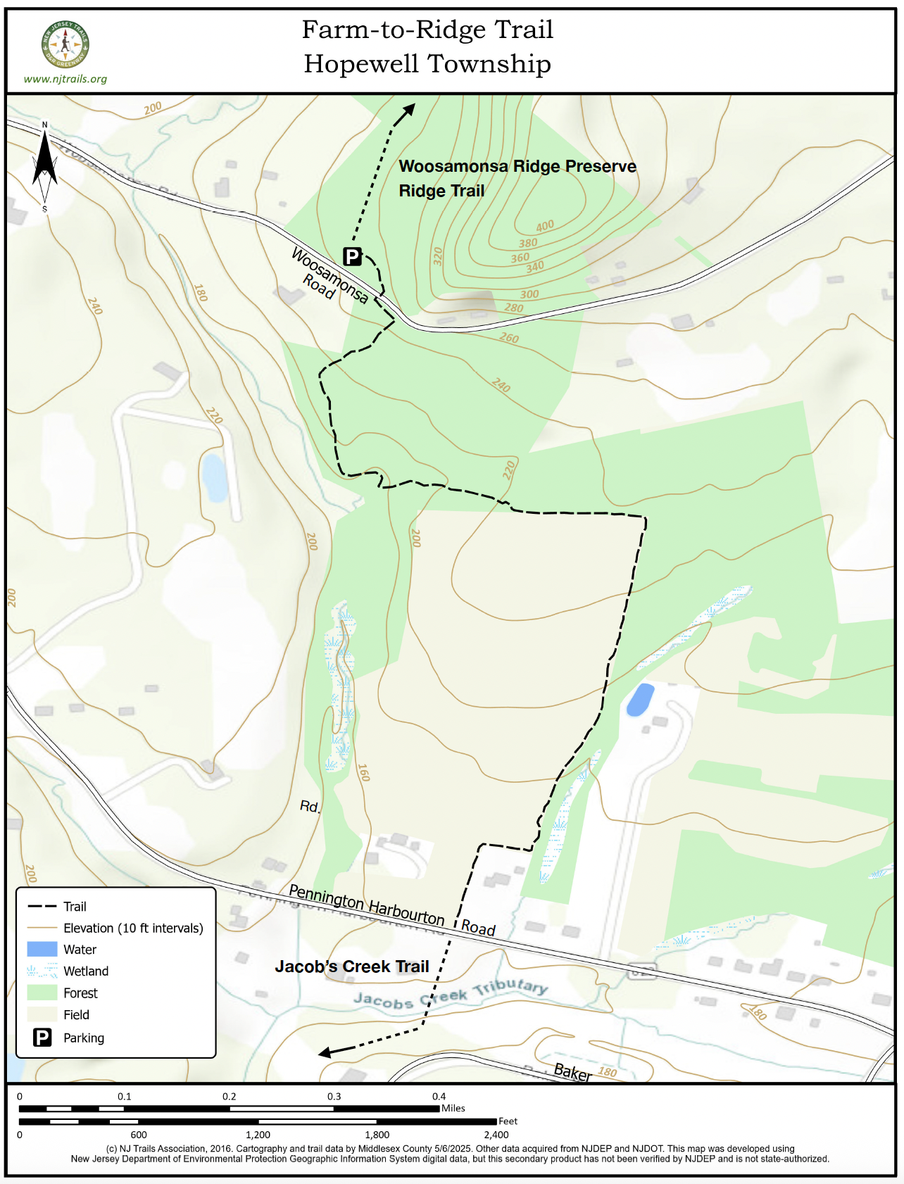
Farm-to-Ridge Trail
Hopewell Township, NJ


Last Updated: 01/20/2026
Overview of Selected Trail
The Farm-to-Ridge Trail, just over three-quarters of a mile long, connects the Woosamonsa Ridge Preserve to the north and the Jacobs Creek Trail to the south. Running from Woosamonsa Road to Pennington-Harbourton Road, it passes through mature forest and along the edges of high farm fields.
-
-
Distance:
.85 miles one way
Time:
This connecting walk can easily be traversed in 20-30 minutes, or used for a pleasant out and back walk in less than an hour.
Markings:
White plastic markers on trees. Marking may be hard to spot on the northern end of the trail at Woosamonsa Road because of frequent tree falls, but there is now a large sign marking the entrance to the trail on Woosamonsa Road.
Trail Usage:
This is a walking/hiking trail. No ATVs, bikes, other wheeled vehicles, or horses are permitted. It is not designed for equestrian use. Dogs must be kept on leash for the benefit of wildlife and fellow hikers. Hunting is permitted on the property during hunting season by permit only, but the trail remains open. For safety, wear orange or yellow safety vests and hats.
Elevation:
There is about a 100-foot elevation difference between the higher northern end on Woosamonsa Road and the lower southern end on Pennington-Harbourton Road.
Difficulty:
Easy. Short, quite moderate inclines as the path descends from the north to a small tributary of Jacobs Creek, climbs back up to the northern edge of the farm fields, and then descends to the south end of the trail.
Parking:
Park at the lot for Woosamonsa Ridge Preserve on Woosamonsa Road, then walk from its kiosk along the marked path to Woosamonsa Road, across from the Farm-to-Ridge trail entrance. No parking at Pennington-Harbourton Road.
Tips:
This trail can be part of a long walk from Harbourton-Woodsville Road (parking there) south through the Harbourton Preserve and Woosamonsa Ridge Preserve, down the Farm-to-Ridge Trail, and continuing south on the Jacobs Creek Trail to Woolsey Park. Use two cars.
The trail is largely on privately-owned property. Stay on the trail. In particular, stay off the farm fields, following visible markers placed on trees hanging over the edge of the farm fields. Do not wander out into the fields. A sign posted as the hiker comes out of the woods going south points to the left along the edge of the woods.
Amenities:
None.
Directions:
The parking lot for the Woosamonsa Ridge Preserve is approximately one mile west of Poor Farm Road and two miles west of Route 31 on Woosamonsa Road. From Trenton-Harbourton Road, the Preserve is approximately one mile heading east on Woosamonsa Road.
-
The northern end of the Farm-to-Ridge trail begins a few feet from a “curve” road sign on Woosamonsa Road. Get there from the parking lot kiosk by following the marked route through the woods to Woosamonsa Road and cross over to the trail entrance.
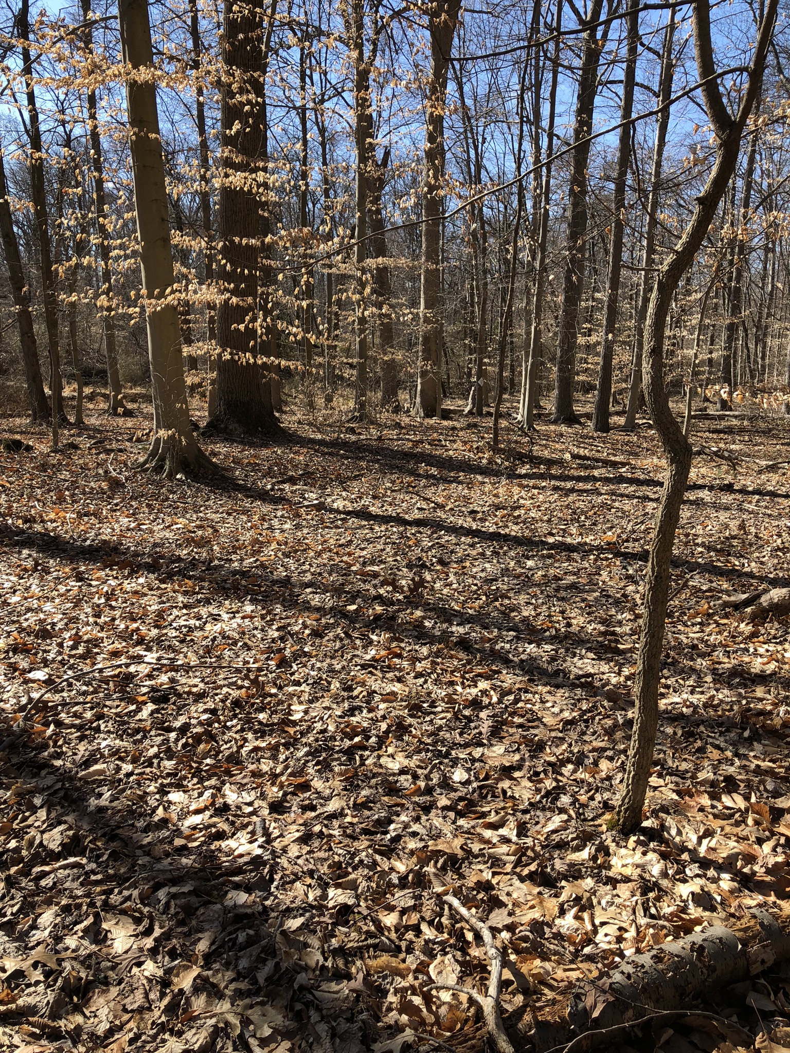
The path winds down through an old garden area now a rough meadow, passes under the limbs of an overhanging tree, and crosses through the remains of an old stone wall into the woods. It’s then an easy walk through quite open forest as the trail heads west and then bends south, offering glimpses of Jacob’s Creek in its ravine to the west. There is a bench approximately 50 yards from the trail close to a section of Jacob’s Creek. The trail descends to and crosses two small brooks that run into Jacob’s Creek and gradually climbs along the southern bank of one of them. As the path rises, it bends to the south away from the small brooks and comes out of the woods on the edge of farm fields.
The walking route then heads east along the eastern edge of the woods, offering long views across the fields sloping down to Pennington-Harbourton Road. At the corner of the field, the path turns south and runs along the edge down towards the road. It jogs right (west) and then south to go around the back yard of the farm’s neighbor, and out to the road.
To continue south on the Jacob’s Creek Trail, walk east (left) along the road about 100 feet until you see that the southern road-bank is lower; then cross Pennington-Harbourton road and follow the rough path back along the road and continue south on the trail.
-
Between Woosamonsa Road and the farm fields is a mature forest of large oaks, poplar tulips, hickory, and beech. Views through the woods are quite pleasantly open, thanks unfortunately to the local deer herd’s browsing of the understory.
Do you have information about this trail?
Click Here to contribute.
-
This area was settled in the 18th century, and the farmhouse whose property the trail crosses dates to that period. Along the banks of Jacob’s Creek (not visible from the trail) are remains of short-lived copper mining efforts. From the trail, where it approaches the two small tributary brooks, if you look west towards Jacob’s Creek, you can make out the straight-line remains of an embankment—a dam that created a millpond. Water was carried through a long wooden sluice, sloping down very gradually, so it could make a substantial fall onto the wheel of a mill down by Pennington-Harbourton Road.
Do you have information about this trail?
Click Here to contribute.
-
Photos
Videos
