Monmouth
Middletown Township
Hartshorne Woods
Middletown Township, NJ 07732


Last Updated: 11/30/2012
Overview of Selected Trail
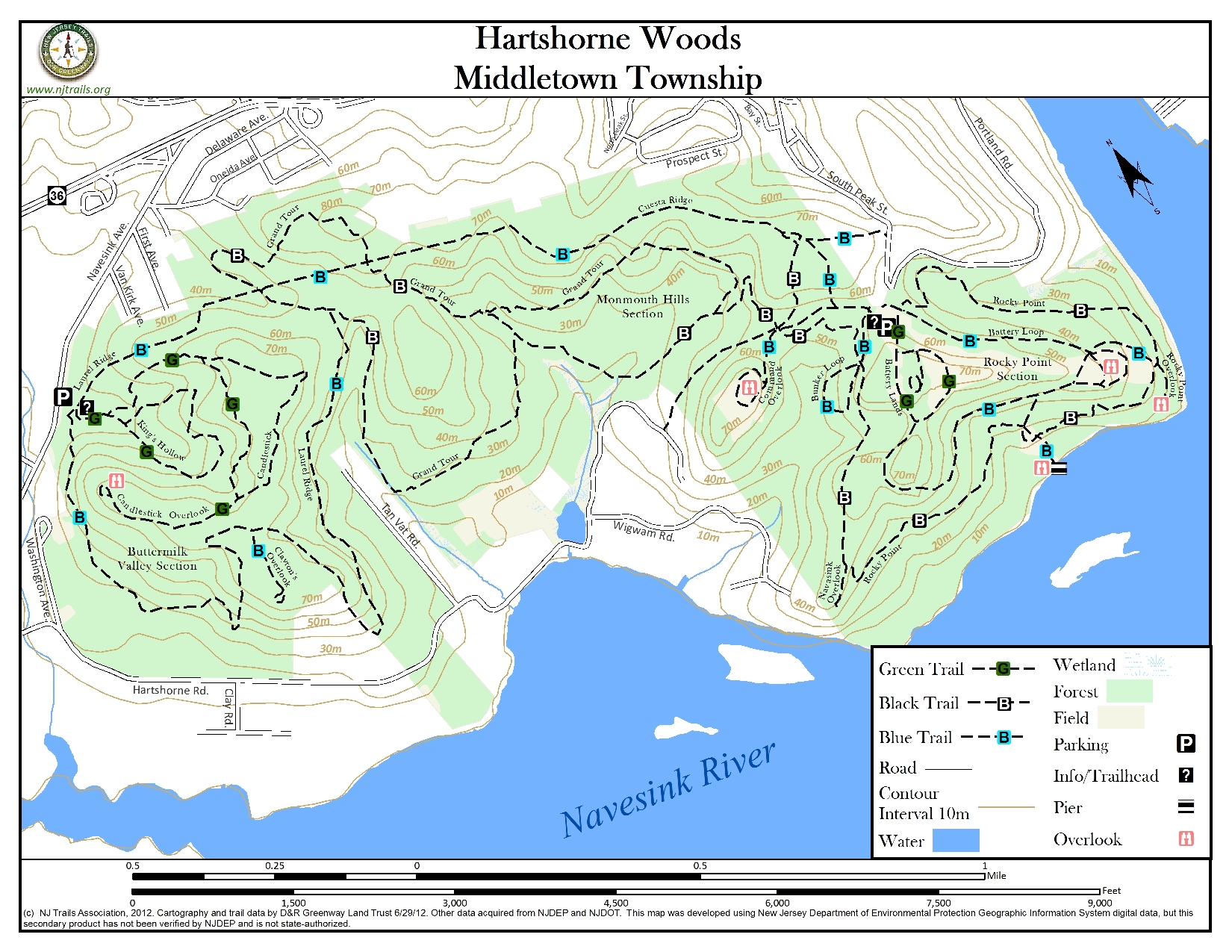
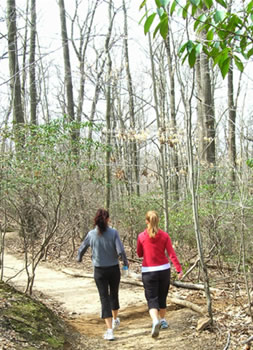
Hartshorne is a large park consisting of 741 acres with two entrances. The Buttermilk Valley section is at the Navesink Avenue entrance and contains three nested trails. The Laurel Ridge Trail is the outer of the three trails, starting out on a wide trail/road and turning into a narrower path along a ridge in the woods. The King’s Hollow Trail is the innermost of the three and the shortest. The Candlestick Trail is centered between the other two, and while not a loop trail, does contain a loop section before reaching the Navesink Overlook. The Rocky Point trail circles the Rocky Point area of Hartshorne Woods, crossing four paved roads, yet staying in the woods all the way. The Battery Loop is paved and circles two World War II gun batteries. Scenic views along this trail are the best in the park. The Grand Tour Trail is like a big figure eight in the middle of the park and can be accessed from either the Navesink Avenue entrance or at the top of Portland Road. The trails can be combined to create interesting circuit walks.
-
-
Distance:
About 13 miles of trail.
Time:
Allow 30 minutes for the shorter trails and 1 ½ -2 hours for the longer trails depending on your pace.
Markings:
Signposts in ground with trail names and arrows.
Trail Usage:
Hiking, Biking and Dog Friendly Trails
Elevation:
The trails wind along a ridge and through the Monmouth hills area and down to the river. Most of the trails involve moderate to steep slopes.
Difficulty:
Two trails (Candlestick and King’s Hollow) are easy with gradual slopes. Battery Loop and Laurel Ridge trails are moderate to difficult with steep grades. Rocky Point Trail and Grand Tour Trail are difficult with challenging sections and steep grades.
Parking:
Navesink Road (Buttermilk Valley) trailhead has 11 paved spaces, plus one handicapped space. There is an additional dirt parking area for approximately 10 cars; Portland Road Parking Area has 47 paved spaces plus 2 handicapped spaces.
Tips:
Park closes at dusk. Walking shoes are recommended. The park ranger’s phone number is (732)872-0336. Bicyclists yield to all other trail users and pedestrians yield to equestrians. Dismount areas are posted for bicyclists and equestrians. Common courtesy is required for safe multiple use on marked trails, leaving plants and animals undisturbed. Trails can be muddy after heavy rains.
Amenities:
Picnic tables and portajohn at trailhead. There is also a kiosk where a large map is displayed. Trail maps and doggie “pooper scooper” bags are available there.
-
The Laurel Ridge Trail climbs through mountain laurel, holly and tall trees. At the top of the climb there is a spur on the left leading to the Clay Pit Creek overlook affording a view of the Navesink River and Oceanic Bridge. This little spur is about 0.4 miles round trip (figure about a 10 minute walk). The trail is 2.5 miles long (about 1 hour 15 minutes hike) and has moderate to fairly steep grades.
The King’s Hollow Trail is easy 0.7 miles long over easy terrain through mountain laurel, oak trees and wildflowers. Enter the trail at the sign indicating “foot traffic only.” At the junction with Candlestick trail, proceed forward. There is an uphill grade through dense mountain laurel and hardwoods to a post trail marker that marks the start/end of loop.
The Candlestick Trail is not a loop. It will take 45 minutes to an hour to walk to the Candlestick overlook and back. The trail ascends through tall tulip, beech and oak trees to a level area. Bear left at the next junction to walk to an overlook. Note the small white marble marker just at the left turn dated 1875 (possibly a property marker for the late Hartshorne family). This easy trail ends at the Navesink Overlook bounded by split rail fencing overlooking thick woods and hills. Circle the overlook and return to the white marker. Follow the arrow left to junction with the King’s Hollow trail. Turn right and descend to the parking lot.
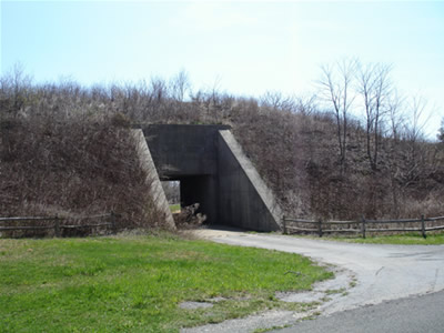
The Rocky Point Trail is a challenging trail with steep grades. It is a primitive trail that is primarily maintained and designed for hardy, experienced hikers, equestrians and all-terrain cyclists. At the beginning of the trail it descends steeply on the Atlantic Ocean side of the ridge through stands of American holly, mountain laurel and tall oak trees. Along the way there are side paths that lead to panoramic views of the Sea Bright peninsula and the Atlantic Ocean. It passes World War II concrete bunkers (with more views of Sea Bright and the Atlantic Ocean). Following the trail will lead to good views of the Navesink River and Rumson. The trail climbs and descends steeply before intersecting Battery Loop Trail and the Grand Tour Trail. It should take 1.5 – 2 hours to cover the 2.6 miles of this trail.
The Battery Loop covers a distance of 1.3 miles and will take less than 30 minutes. The entire loop is paved and has the best scenic views in the park. The Rocky Point area is one of the highest points on the east coast and a natural site for gun emplacements for coastal defense. Remnants of World War II gun batteries and ammunition bunkers are still in place. The trail starts at the highest point in the park and descends half way to the river. The steep hills on the trail make this a vigorous to moderate walk. The Battery Loop Road winds around two batteries and has several side paths to the top of the batteries from which are one can see the islands in the Navesink, Sea Bright, the Shrewsbury Channel and the Atlantic Ocean. One side path descends to the Navesink River. There are picnic tables in several areas along the loop.
The Grand tour Trail makes a large figure eight around and over the Monmouth Hills Section of the park. It intersects the Laurel Ridge Trail, the Cuesta Ridge Trail (an access road) and a fire road. At less than 4 miles (1 ½-2 hours) it is the longest trail in the park. This trail can be accessed from either the Navesink Avenue entrance or Portland Road entrance. The steep hills make this a challenging trail for hikers and bicyclists. Starting from the Navesink Road entrance bear left and take the Laurel Ridge Road to the intersection of Laurel Ridge, Cuesta and Grand Tour trails. Take the Grand Tour Trail left. Follow the trail as it climbs uphill. After crossing a fire road continue to the top, which is near the highest point of the park. The trail crosses the fire road several times and Cuesta Ridge trail (the backbone of the park) once. It will climb and descend through stands of mountain laurel and holly and intersects Rocky Point Trail and joins Laurel Ridge Trail.
-
There is an environmental education center located at Manasquan Reservoir in Monmouth County that describes the plants, bids and wildlife in the area. See the following website for more information: Monmouth County Parks.
Do you have information about this trail?
Click Here to contribute.
-
Harthorne Woods Park is named for Richard Hartshorne (pronounced “harts-horn” meaning horn of the heart or stag), who sailed into the Highlands in 1670 and cleared title to land overlooking the Navesink River, settling directly with the Indians who felt they had not been compensated for the land. Several Hartshorne descendants still live on a portion of the original family compound overlooking the Navesink River.
The Rocky Point area is one of the highest points on the east coast and a natural site for gun emplacements for coastal defense. Remnants of World War II gun batteries and ammunition bunkers are still in place.
Additional trails are possible throughout Monmouth County. Visit the following website: Monmouth County Parks.
Do you have information about this trail?
Click Here to contribute.
-
Photos
Videos
