Monmouth
Upper Freehold Township
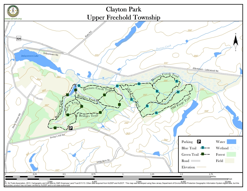
Clayton Park
Upper Freehold Township, NJ 08514


Last Updated: 11/19/2013
Overview of Selected Trail
Clayton Park is a 421-acre site in Upper Freehold Township in the western section of Monmouth County. The park is known for its gorgeous stands of red and white oak, beech, ash and birch trees. Two easy trails (Glen and Bridges) start at the trailhead and lead to another two moderate trails (Old Forge and Doctors Creek trails).
-
-
Distance:
Almost 6 miles total
Time:
Complete exploration would merit at least two hours
Markings:
Signposts in ground, sometimes misleading
Trail Usage:
Walking/Hiking, Horseback riding, Dogs permitted on leash, Mountain biking
Elevation:
Varies from 100 to 280 feet
Difficulty:
Easy to moderate, including gentle ups and downs.
Parking:
Parking off Emley’s Hill Road: gravel lot with overflow parking on grass.
Tips:
The layout and naming of trails is confusing. Trails with the same color markers intersect, and trails with the same name seem to go in more than two directions at some trail intersections. Pay attention to the map, but also use your own common sense.
Admire the treescape, but watch for horse droppings!
Amenities:
Picnic tables and portajohn at trailhead. There is also a kiosk with a large map of the park. Trail maps and doggie pooper scooper bags are available there. Pick up a park map to check for trail changes.
Directions:
From Interstate I-195 East: Take Interstate 195 East to Exit 11 toward Imlaystown. There are brown “Clayton Park” signs at each turn. Turn south and follow to end. Turn left onto Route 526 and make immediate right onto Imlaystown-Davis Station Road. Follow to Emily’s Hill Road, turn left. Follow to park on left.
From Interstate I-195 West: Take Interstate 195 West to Exit 16. Turn south toward Six Flags Theme Park. Pass the Park and take the first right onto Millers Mill Road. In about 1 mile the road bends sharp left onto Burlington Path and shortly comes to a 4-way stop. The Emley’s Hill United Methodist Church is on the right. Turn right onto Emley’s Hill Road (it is not marked here). Watch for the parking lot on right in about 1 1/2 miles.
From Rt 537: Follow 537 west to Rt 526 (becomes Red Valley Road) to Imlaystown-Davis Station Road. Turn left and follow Imlaystown-Davis Station Road to Emley’s Hill Road. Turn left and follow to Park on left.
-
The Glen trail starts behind the kiosk. In about 100 feet it splits in a “Y” at a Bridges trail sign post. Go left, and shortly come to a “T” where you may take either direction because it is a loop. Left descends along a ridge path giving a nice view of the valley and stream below. It meets the Bridges trail.
The Bridges Trail has two possible entrances. One is behind the kiosk a short distance along the Glen trail. Go this way to access the longer Doctors Creek and Old Forge trails. The other entrance is to the left of the parking lot as you face the kiosk, near Emley’s Hill Road. Look for a partial wooden fence and a post marker indicating the Bridges trail. This entrance leads to a series of actively farmed fields. As you enter, the dirt path goes to the right (but you can walk around the fields in either direction). If you follow the dirt path to the right, the field is to your left and the woods, with a dense understory, are to your right.Following either route around the edge of the fields, you eventually come to the Imlaystown Lake area. There is private property to the left (west) of this area, which you must respect.
A line of maintained bluebird boxes placed around the fields to encourage bluebird nesting begins in this section and continues throughout the fields beyond where the Bridges trail turns into the woods. A post indicates the continuation of the Bridges trail into the woods. The trail makes a series of loops leading back to itself, or to the Glen trail and trailhead, or to the intersection of the Doctor’s Creek Trail and Old Forge trail. It is easy to get confused on this trail with all its branches and loops. It is strongly suggested that you take a trail map to guide you.
The Doctor’s Creek trail can be entered in two places. The Bridges Trail reaches a boardwalk at the northern end of its western-most leg, and the Doctor’s Creek Trail takes off from the other end of the boardwalk. The Doctor’s Trail can also be reached from the easternmost bridge on the Bridges trail, by taking the Glen Trail, taking a right onto the Bridges Trail at a the “Y” after about 100-200 feet, and then after a long downhill slope and a bridge, going right at a “T”, and later right at a “Y” fork leads to a bridge and Doctor’s Creek Trail.
Doctors Creek trail follows a ridge along the creek through beautiful hardwood forest, and then splits into a loop. The loop reaches a 4-way intersection with the Old Forge trail (with a confusing signpost marked “Doctor’s Creek Trail” on three sides!). The Doctor’s Creek Trail at its eastern end parallels a farm fence and a chance to admire horses on the other side–and reaches an elevation of 250 feet.
The Old Forge trail starts from the easternmost bridge on the Bridges trail where it meets the Doctor’s Bridge Trail. This trail also consists of a “stem” segment that splits into a loop. The southern leg of the loop parallels the Doctors Creek trail, but on a different ridge. The trail bends around toward the creek below and meets again with the Doctors Creek Trail before completing its loop.
-
Clayton Park is a second growth forest containing oaks, maples, beeches, and walnut trees.
Do you have information about this trail?
Click Here to contribute.
-
The Monmouth County Park System purchased 176 acres in 1978 from farmer Paul Clayton and his daughter Thelma. Mr. Clayton avoided modern farming methods, working the fields with horses to grow potatoes, tomatoes, grain and corn until 1971 when he retired at age 87. He resisted offers from people interested in buying the property to harvest trees, and sold instead to the Park System at a price below market value. The remaining acres of the park were added in subsequent purchases from other landowners .
Do you have information about this trail?
Click Here to contribute.
-
Photos
Videos
