Mercer
Hamilton Township
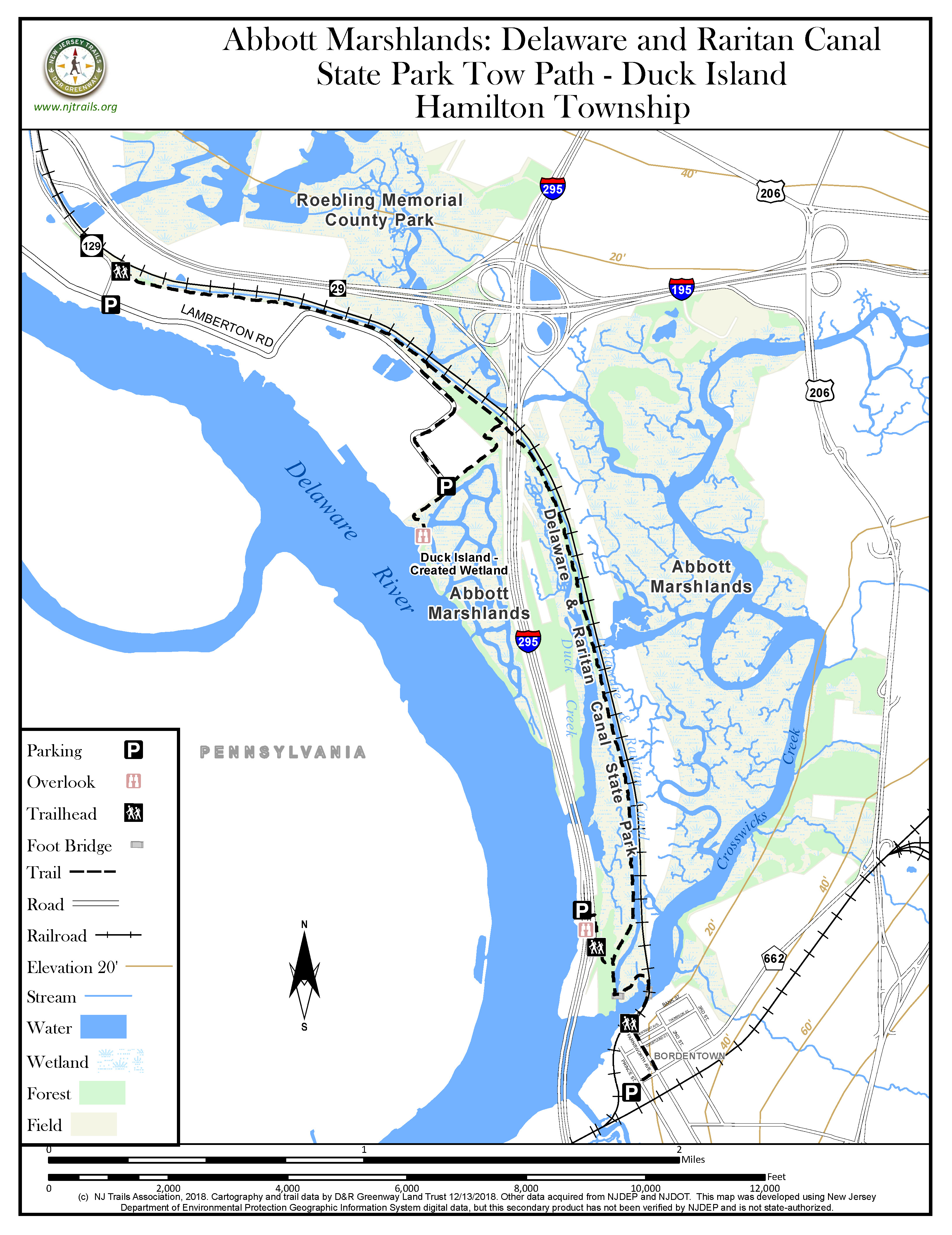
Abbott Marshlands: Delaware & Raritan Canal State Park Towpath – Duck Island
Hamilton Township, NJ 08611


Last Updated: 01/17/2019
Overview of Selected Trail
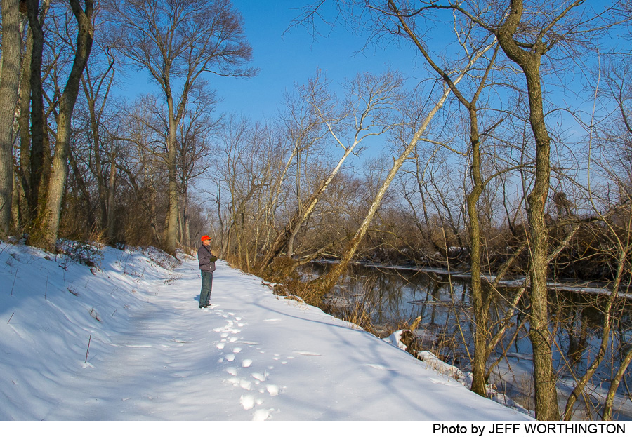
This trail follows the historic D&R Canal towpath through areas of second growth woods, swamp, and marsh—an oasis of wild land for songbirds, waterfowl, turtles, amphibians, bees, and butterflies. For information, see www.abbottmarshlands.org.
-
-
Distance:
3.1 miles
Time:
60-90 minutes
Markings:
None. The trail is the old towpath along the canal.
Trail Usage:
Walking/Hiking, mountain biking. Dogs permitted on leash. No motorized vehicles permitted. Wheelchair accessible, but not paved.
Elevation:
Flat
Difficulty:
Easy walking throughout
Parking:
From the North: Take exit from NJ 129 south to Duck Island/ Lamberton Road. On left, past Sturgeon Pond look for a park gate and north entrance. There is parking for 20 cars along the road edges, with room for more along Lamberton Road.
Turn left onto Lamberton Road; a small parking lot at a park gate holds 8 cars.
Please do not block gates.
South end: from Interstate -295 northbound or southbound, exit to the Scenic Overlook. There is a parking lot for 24 cars on each side. A pedestrian bridge crosses the highway for access to the towpath trail from the southbound parking lot.
In Bordentown, park at the Light Rail Station, walk up Park Avenue and turn left on Farnsworth Avenue. At bottom of the hill is a bridge that crosses Crosswicks Creek and leads to the towpath trail.
Note that there are branch trails that will take you to the Delaware River. These are shown on the towpath trail map.
Tips:
Insect repellent for mosquitoes is recommended in the warm months. Note: be especially careful around water; currents can be fast and dangerous.
For more information about the Abbott Marshlands, scheduled field trips, guides, etc., visit www.abbottmarshlands.org.
Amenities:
Seasonal toilets: At the north end, go to the Trenton Boat Launch (north about ½ mile on Lamberton Road) and at the south end, go to the Bordentown Beach. The park is open from sunrise to sunset.
Directions:
To North end trail entrance and D&R Canal State Park: From NJ 129 heading south, take the Lamberton Road exit. Just past Sturgeon Pond on the left is the north gate. There is parking along the roadside. At the T intersection, turn left onto Lamberton Road and continue south one mile to a small parking lot; a park gate is on the left under the electric towers. At the south end of Lamberton Road, a parking lot provides access to the Delaware River (west). A connector trail to the towpath is available on east through a chain link fence.
South end: Take I-295 to the Scenic Overlook just north of Bordentown. From the southbound side parking lot, take the pedestrian bridge across the highway.
Bordentown entrance: From Route 206, turn onto West Park Street into Bordentown. Continue to its end and park at the Light Rail Station. Walk back up Park St. and turn left on Farnsworth Avenue. At the bottom of the hill take bridge over Crosswicks Creek to towpath trail. Alternatively, take light rail to Bordentown.
-
This path follows the D&R Canal through woods, marsh, and meadow-like open areas. Most of the Canal Lock 1 is tidal due to its opening onto Crosswicks Creek, which is tidal. Duck Creek, also tidal, is on the west, south of the highway overpass. At the south end is a replica of a 19thC bridge that crosses Lock 1. Cross this replica bridge and continue along the path to the bridge over Crosswicks Creek and into Bordentown City. The Light Rail train follows 1830s railroad tracks along the canal on the east side. Beyond the train tracks to the east is tidal freshwater marsh. Along the path, look for a variety of songbirds, in the canal water birds (ducks, herons), and overhead eagles. The wildflowers in spring and the colorful trees overarching the canal in the fall make this a photographer’s destination.
Watch for evidence of beaver activity, ranging from gnawed trees to lodges.
-
The towpath and the surrounding marsh, creek, and canal create an oasis for plants and animals. In wetlands look for characteristic woody species, such as cottonwood, box elder, sycamore, and river birch. In upland woods, especially at both ends of the path, there are large tulip poplar, ash, black locust, tree of heaven and princess trees. Where the woods are thin, during spring and summer, wisteria, multiflora rose, or honeysuckle flowers scent the air. In the canal, there are yellow pond lilies, cattails and wild rice (late summer). Along the towpath itself, look for sassafras, elderberry, or arrow wood viburnum, as well as nonwoody plants such as Solomon’s seal, blue eyed grass, and sweet vernal grass.
Invasive plants are prominent at both ends: at the north end is Japanese bamboo and at the south end is wisteria.
The towpath is a wonderful place to find resident and migratory songbirds including catbirds, redstarts, rose-breasted grosbeaks, northern (Baltimore) orioles, phoebes, indigo buntings, gold finches, and red-winged blackbirds. About 1 mile north near a cement milepost, there is a good view of a bald eagle’s nest in a dead tree in the marsh on the east side of the path. Insects include many dragonflies and butterflies (skippers, swallowtails and sulfurs).
In the canal and Duck Creek look for eastern painted turtles and red sliders. Fowler’s toads can be seen along the towpath while spring peepers and wood frogs contribute to an early spring chorus.
Mammals, though not often visible, include beaver, muskrat, white-tailed deer, cottontail rabbits and grey squirrels.
(Inventory lists can be found at www.abbottmarshlands.org, under Ecology).
Do you have information about this trail?
Click Here to contribute.
-
The 44-mile main canal and 22-mile feeder were built in the 1830s. Dug by hand, mostly by Irish immigrants, the main canal — 75 feet wide and 7 feet deep — carried barges from the Delaware River at Bordentown to the Raritan River at New Brunswick. It also carried coal from the Pennsylvania mines to meet the booming industrial and residential needs of New York City. In the 1860s and 1870s, 80 percent of the cargo carried on the canal was coal. A lake that was used as a turning basin for the barges can be seen in the marsh about halfway along the trail (east of railroad tracks). There was a thriving brick-making industry here in the 1800s. At the beginning of the Civil War the Canal was critical in moving 10,000 NJ troops to Washington, DC to protect the Capitol from the Confederate Army located in Virginia.
The D&R Canal as a whole has served three functions since it opened in 1834. First it provided an inexpensive means to move freight between the Raritan and Delaware Rivers. It was a critical link for nearly 100 years in the network of rivers and canals that linked the Pennsylvania coalfields to New York and other cities. Second, it has provided water to meet the growing residential and industrial needs of central New Jersey. After shipping on the canal ended in the 1930s, it was rehabilitated to serve as an important water supply system that now provides water for 1.5 million NJ residents. Its third function, and today the most obvious, is that of an informal recreation area. In 1973, the D&R Canal and numerous structures along the canal were put on the National Register of Historic Places; in 1974 the New Jersey Legislature created the Delaware & Raritan Canal State Park and the Delaware & Raritan Canal Commission, beginning the long process of developing a priceless recreational and natural resource with links to many historic sites.
At two points in the Canal and at the southern tip of Duck Island near the bridge over Crosswicks Creek, it is possible at low tide to see remnants of sunken barges.
Locks 1 and 2 were abandoned during the winter of 1932. The entire canal was taken over by the state of NJ by 1936. Parts of the canal between Trenton and Bordentown were filled in for various road and rail projects and are no longer visible. This towpath trail, along Lock 1 on Duck Island, was restored for recreation and opened in 2010.
Do you have information about this trail?
Click Here to contribute.
-
Photos

Videos
