Hunterdon
Flemington
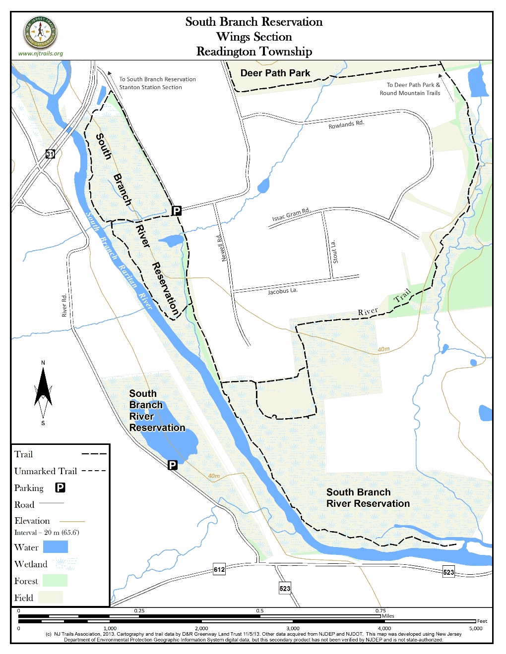
South Branch Reservation: Wing’s Section
Flemington, NJ 08822


Last Updated: 12/26/2013
Overview of Selected Trail
The South Branch Reservation is a collection of 12 small parks totaling about 1000 acres, and running, with two minor exceptions, about 10 miles along the South Branch of the Raritan River between Flemington and Clinton. The southern half is more developed from a hiking trail perspective, and forms a contiguous area with Deer Path and Round Mountain Parks, also owned by Hunterdon County. Included in this half are the Wings Section, the Stanton Station Section (see separate trail guide for this trail), and the Assiscong Marsh Natural Area, the latter having no hiking trails. In general, the entire reservation seems to be a work in progress, and some of the trails indicated on the county maps either don’t exist yet or tend to disappear without warning. Trails are generally marked with orange diamonds, and trail maintenance varies considerably. All trails are designated for hiking, biking and horseback riding, but most are used very infrequently.
-

-
Distance:
There are approximately 2.5 miles of signed trails in the Wings Section
Time:
Allow 35-40 minutes for doing complete trail. Allow more time if hiking with children.
Markings:
Trails in Wing’s Section have orange diamonds nailed to trees, except where there are mowed paths to follow. Some bridle trails are marked with “RTA” markers.
Trail Usage:
Walking/Hiking, Horseback riding, Dogs permitted on leash, Mountain biking
Elevation:
Trails in Wing’s Section are essentially flat.
Difficulty:
Wing’s Section Trails and the associated bridle trails are generally easy except where lack of mowing or trail maintenance makes for difficult passage.
Parking:
Deer Path, Round Mountain and Wings are located in Readington Township, four miles north of Flemington off Route 31. For Wings, immediately after crossing the South Branch of the Raritan River on Route 31, turn right onto Deer Path Road and go about 0.3 mile to a sharp left turn. Pull straight ahead into a small parking area. A signed dirt trail is off to your right and a wide, mowed lane is straight ahead beyond a vehicle gate.
Tips:
Wetlands exist in the area. After rains be prepared for muddy conditions. Wear shoes with good tread for walking on wet trails.
Amenities:
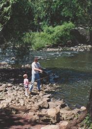
Wing’s Section is classified under Hunterdon County Parks as a Fisherman’s Trail. There is access for fishing at the southern part of the Wing’s Section in South Branch Reservation.
Directions:
Deer Path, Round Mountain and Wings are located in Readington Township, four miles north of Flemington off Route 31. For Wings, immediately after crossing the South Branch of the Raritan River on Route 31, turn right onto Deer Path Road and go about 0.3 mile to a sharp left turn. Pull straight ahead into a small parking area. A signed dirt trail is off to your right and a wide, mowed lane is straight ahead beyond a vehicle gate. For the other two areas, take the next right turn off Rt. 31, West Woodschurch Road, and turn right into the park driveway after 0.6 mile. Keep left past the YMCA building, and park in the next lot on the left. To access the Round Mountain section, walk to the left of the left-hand soccer field and look for the park signs across the road. For the Deerpath trails, which will not be described below, walk in any direction until you come to a mowed trail. Assiscong Marsh is in Raritan Township, just across the river. To access the 26 acre marsh, which is great for wildlife viewing, go two miles north of Flemington and turn right on Bartles Corner Road. After 0.6 mile, go left on River Road. Parking is on the right after 0.2 mile.
-
Deer Path and Round Mountain are separate sections of the same park, separated by West Woodschurch Road in Readington Township. Deer Path is a flat, active recreation area, with soccer and softball fields, picnic and play areas, and a three acre pond. In this section are walking and fitness trails, notably around the perimeter and consisting mainly of paths mowed in the grass. The Round Mountain section, on the other hand, is hilly and wooded, with narrow trails and old logging roads on the sides of the mountain. Hunting is allowed in the latter by special permit at certain times. There are also marked bridle trails associated with both areas that are maintained by the Readington Trails Association, and these are open for hiking as well.
From the parking area, the main trail goes straight ahead as a wide, mowed lane beside houses and stables for 0.4 mile before becoming a dirt trail through the woods, with several nice views of the river (freight trains on the far side can briefly disrupt the serene atmosphere). At this point, a trail coming from the left is the end of the bridle trail described below under Round Mountain. In another 1/4 mile, an intersection is reached with an unmarked trail to the left. This trail deadends at a cornfield after 0.1 mile.
Beyond this point, the main trail continues for another 0.4 mile along the river, but trail marking and maintenance vary considerably from one spot to the next, and several sections can be something less than a joyful experience (at least without a horse), due mainly to multiflora roses and other invasive species. The trail ends at a small stream, and hikers will be more than ready to turn around by then.
After 0.2 mile from the parking area, a dirt trail (marked) descends a bank and turns to the right after reaching the river. (Several others in this area on county maps don’t exist.) After running along the river for 1/4 mile and crossing 3 small footbridges, it intersects a trail that returns to the parking area in 1/8 mile. Continuing straight along the river for another 1/4 mile brings one to the Route 31 bridge. Walking under it will lead to a jeep road on the other side, but this only goes for a short way before ending at Route 31. An unmarked trail runs up the near side of the bridge for a short way and becomes a jeep road before reaching Deerpath Road. Going right on the road for 0.3 mile will bring one back to the parking area.
Consult the Hunterdon County website for further parks information: Hunterdon County Parks.
For more information about land preservation efforts within Hunterdon County, please go to: Hunterdon Land Trust Alliance.
-
There are many types of trees, including oak, maple, ash, beech, white pine and red cedar. Woodland birds such as wood thrush, yellowthroat and black-throated blue warbler are frequently sighted. Other sightings may include bluebird and kestrel, along with wild turkey, as well as deer, red fox, raccoon and skunk. Hunting is allowed by special permit during parts of November and December, and hikers are advised to wear bright clothing during those periods.
Do you have information about this trail?
Click Here to contribute.
-
The Wing’s Section of the South Branch Reservation is named after William Wing, a farmer who once owned the land. Consult the Hunterdon County website for further parks information Hunterdon County Parks.
Do you have information about this trail?
Click Here to contribute.
-
Photos
Videos