Middlesex
Old Bridge Township
John A. Phillips Preserve
Old Bridge Township, NJ 08857


Last Updated: 12/03/2020
Overview of Selected Trail
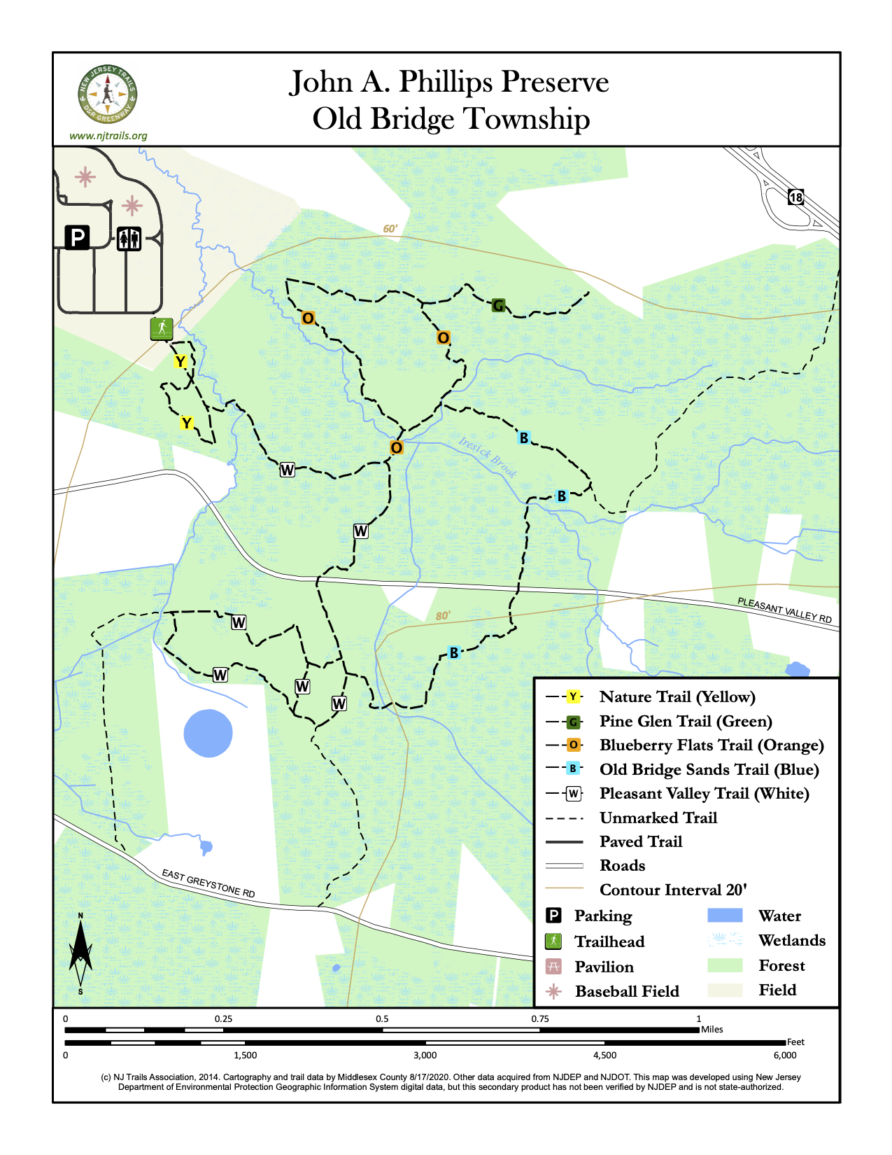
The John A. Phillips Preserve is the largest contiguous holding in the County’s park system. At 1,728 acres, it falls directly in the Spotswood outlier, a small “island” of pine barrens habitat, approximately 20 miles north of the main core of the NJ Pinelands. The main core of the NJ Pinelands covers parts of nine counties in southern New Jersey. The Spotswood outlier is physically separate from the core of the Pinelands, but is ecologically the same. The Phillips Preserve offers approximately 6.5 miles of marked or paved hiking trails, as well as numerous unmarked sand roads. There is a .5 mile self guided nature trail with interpretive brochures available at the trailhead.
-
-
Distance:
Nature Trail (yellow blazes): 0.5 miles; Pleasant Valley Trail (white blazes): 2.1 miles; Blueberry Flats (orange blazes: 0.95 miles; Old Bridge Sands Trail (light blue blazes): 1.1 miles; Pine Glen Spur (green blazes) – formerly they were white, now green: 0.3 miles; Park Loop (paved): 1.75 miles
Time:
Nature Trail: 15-30 minutes Pleasant Valley Trail: 60-90 minutes Blueberry Flats: 30-45 minutes Old Bridge Sands Trail: 45-60 minutes Pine Glen Spur: 10 minutes Park Loop: 15-30 minutes
Markings:
Please note: There are several miles of unmarked sand roads and trails at the preserve. Please use caution when hiking any of these trails and consult your map carefully.
Trail Usage:
Walking/Hiking, Dogs permitted on leash
Elevation:
Minimal elevation change along all trails
Difficulty:
All trails are easy to moderate level
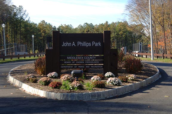
Parking:
Parking is available at John A. Phillips Park. The trailhead is at the south east corner of the soccer fields along the wood line.
Tips:
The trails can be muddy in spots, especially in the spring, so adequate footwear is important. All stream crossings now have bridges.
Note: Secluded, rarely see other hikers during the week. Weekends the trails do see some use. Expect to see other hikers.
Our trails are open from sunrise to sunset. All dogs must be on leashes. Please feel free to pick up any litter on our tails.
Bicyclists must Yield to all other tail users. Pedestrians must yield to Equestrians.
Trails are mostly dry after a day of rain, some areas would be undesirable to walk on during rain, because of slippery rocks and Bog-walks.
An information kiosk is located at the head of the Nature trail.
For assistance, Park Ranger Unit #732-745-3800
Amenities:
John A. Phillips Park is open from dawn to dusk and contains restroom facilities, water fountains, a playground and an array of recreational facilities including soccer, baseball and softball fields as well as a cricket pitch. A permit is required for use of the recreational fields.
Directions:
From New Brunswick:
From the junction of Route 1 and Route 18, travel Route 18 South for approximately 8 ½ miles, Turn right at traffic light onto Maple Street (Wawa on the corner). Park entrance is at the end of Maple Street.
From New Jersey Turnpike:
Take Exit 9 (New Brunswick) onto Route 18 South. Follow Route 18 South for approximately 8 miles. Turn right at traffic light onto Maple Street (Wawa on the corner). Park entrance is at the end of Maple Street.
-
Nature Trail:
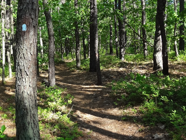
The Nature Trail is a self-guided interpretive trail that provides a leisurely walk through forests of pitch pine, sweet pepperbush and blueberry. The 0.5 mile loop explores the unique pine barrens habitat and the plants and animals found at the preserve. The Nature Trail is marked with yellow blazes and interpretive guides are available at the trailhead kiosk.
The Nature Trail begins along a wide sand road, just adjacent to the trailhead kiosk. Following the yellow paint blazes, the trail turns left, shortly after the first interpretive stop. The trail meanders through the forest, passing along the Iresick Brook and crossing the wide sand road just after the third interpretive stop. Entering the forest on the other side of the sand road, the trail continues to wind through the forest of mature pitch pines and white oaks and again returns to the wide sand road after the seventh interpretive marker. Turn left on the sand road. The Pleasant Valley Trail (white blazes) intersects on your right just before the ninth interpretive stop, while the sand road returns you to the trailhead kiosk.
Pleasant Valley Trail:
The Pleasant Valley Trail begins at the junction with the Nature Trail, approximately 0.2 miles from the trailhead kiosk. The trail begins along an old sand road and presents the hiker with a wonderful view of the two main forest types at the preserve. Initially, you are in an upland forest with sandy soils and traditional pine barrens flora including pitch pine, scrub oak and low lying shrubs in the heath family. The trail then quickly changes to a “wetter” forest dominated by sweet gum and red maple. The trail is marked with white blazes and involves a road crossing at Pleasant Valley Road. Please use caution when crossing the road. Both Old Bridge Sands Trail and Blueberry Flats intersect with the Pleasant Valley Trail.
The Pleasant Valley trail leaves the Nature Trail 0.2 miles from the trailhead kiosk and quickly forks to the left, crossing a bridge over the Iresick Brook. The trail continues along a wide sandy road with several unmarked trails leading off to the left, until it reaches the intersection with the Blueberry Flats trail (orange blazes) on the left at 0.4 miles. The Pleasant Valley trail continues straight ahead and reaches Pleasant Valley Road at 0.6 miles. Please use caution when crossing the road. Once across the road, you should notice a distinctive change in the vegetation where sweetgum and red maple have replaced the pitch pine, and the formerly dense understory is nearly absent. Leaving the road, the trail continues along wide dirt path, turning right at 0.7 miles. Shortly thereafter, the trail passes a large sand “pit” created by illegal ATV use. Here the trail turns right, with a shorter spur to the left. Following the trail right, it winds again through a younger, more open forest before returning to the wide dirt road at 1.4 miles. (A right hand turn follows the unmarked dirt road 0.3 miles to East Greystone Road.) Turning left, the trail continues back towards Pleasant Valley Road, passing the junction with the Old Bridge Sands trail (blue blazes) on the left at 1.5 miles. Continue following the white blazes back across Pleasant Valley Road to the junction with the Nature Trail at 2.1 miles.
Blueberry Flats:
The Blueberry Flats trail begins at the junction with the Pleasant Valley Trail, 0.6 miles from the trailhead kiosk. It is a 1 mile loop through upland pine barrens habitat, dominated by low bush blueberries and huckleberries. This trail provides the hiker with the sites, sounds and smells of this unique area. The trail is marked with orange blazes and both the Pine Glen spur and the Old Bridge Sands trail intersect with the Blueberry Flats trail.
From the start at the Pleasant Valley Trail, the trail descends slightly and crosses a footbridge over the Iresick Brook. Just before crossing the bridge, take notice of a native plant restoration to the left. This goal of this restoration is to restore the damage created by ATV use. Both the footbridge and native plant restoration were projects of the Middlesex County Conservation Corps.
Leaving the footbridge, the trail reaches a fork. Turning left, the trail winds through stands of mature pitch pine, while the understory is dominated by blueberry, deer-berry and huckleberry. Good berry picking time is mid-summer, if you can get to them before the animals. Also, take notice of the blackened trunks of some of the trees. These are scars from previous fires. Fire plays an important role in the renewal of pine barrens habitat. The trail continues on the level, crossing two low areas on bog walks. The Pine Glen spur (white blazes) is reached on the left at 0.7 miles. Turning right, follow the orange blazes through another low, wet area, reaching the junction with the Old Bridge Sands trail (blue blazes) on the left at 0.9 miles. Turn right and follow the orange blazes back to the footbridge, returning to the junction with the Pleasant Valley Trail at 1.0 miles.
Old Bridge Sands Trail:
The Old Bridge Sands trail starts at the junction with the Blueberry flats trail, approximately 0.2 miles from the Pleasant Valley Trail. The trail crosses several feeder streams to the Iresick Brook and is named for the Old Bridge Sands aquifer which lies beneath the trails of the preserve and is considered a major water supply aquifer for the region. The trail is marked with light blue blazes and connects with the Pleasant Valley Trail, south of Pleasant Valley Road.
From the start at the junction with the Blueberry Flats trail, the trail immediately crosses a footbridge. The trail continues through pitch pine along an old, winding sand road. At 0.5 miles, the trail will turn right, while the old sand road continues straight ahead (eventually ending at Route 18). Follow the light blue blazes to the right, making another right in another 100 feet. The trail continues through mostly pitch pine until it reaches another footbridge. Immediately after the footbridge, a series of causeways and board walks carry the trail over a seasonally wet area. The trail continues up a small hill and reaches Pleasant Valley Road at 0.7 miles. Please use caution when crossing the road.
Once across the road, the trail continues to meander through the pitch pine forest before descending slightly to a series of bog walks at 0.9 miles. At the end of the bog walks, follow the trail to the right. The trail crosses a small feeder stream on the Lukas Anderson Memorial Bridge. Lukas Anderson was a member of the Middlesex County Youth Conservation Corps and dedicated many hours to trail work at the John A. Phillips Preserve before his passing. Shortly after crossing the bridge, the trail ends the junction with the Pleasant Valley Trail at 1.1 miles.
Pine Glen Spur:
The Pine Glen Spur connects the Blueberry Flats trail to two apartment complexes along Route 18. This trail provides local users with access to the trail network and John A. Phillips Park.
-
The John A. Phillips Preserve encompasses more than 1700 acres of forest, stream and wetlands. The Preserve is located in the Spotswood outlier, a unique “island” of Pine Barrens habitat. Dominant plants include pitch and shortleaf pines, scrub oaks, and several members of the Heath family including high and lowbush blueberry, dangleberry and black huckleberry. The Phillips Preserve is also home to rare orchids like the pink lady’s slipper. Over 50 species of nesting birds have been identified including pine warbler, black & white warbler, yellow-billed cuckoo and indigo bunting. Red fox sightings are fairly common as are the rounded ridges left by the eastern mole as it tunnels through the sandy soil. Watch for “pitfalls” of doodlebugs or more accurately, antlion larva. These industrious insects build an inverted cone in the sandy soil where they patiently wait at the bottom of the cone for their next meal. The preserve is also home to the locally rare southern ring-neck snake. Several Bio-Blitz events were held at the preserve in conjunction with the Chrysler Herbarium at Rutgers University.
Do you have information about this trail?
Click Here to contribute.
-
The land for the John A. Phillips Preserve was acquired in 1997 and was one of the first purchases of the Middlesex County Open Space and Farmland Preservation Trust Fund. The property was acquired from Olympia and York, a development corporation who had planned nearly 10,000 high density housing units for the area. Shortly after the land was protected, plans were made for the 100-acre John A. Phillips park which would provide recreational facilities for that area of the county, while leaving the remaining 1600-acres for passive recreation. Trails were laid out, constructed and are maintained by the Middlesex County Conservation Corps. The MCCC was proposed by the late Freeholder Director, David B. Crabiel to help meet the management needs for the additional land acquired through the Open Space Trust Fund. For more information on the MCCC, visit the website.
John A “Jack” Phillips was a resident of Laurence Harbor for 40 years. He served as a councilman in Old Bridge Township from 1958-1960 and as the mayor from 1960-1962. He was also a Middlesex County Freeholder from 1962-1983, serving as the Deputy Director from 1973-1983. He was a founding member of the Friendly Sons of the Shillelagh and was very active in the township’s Little League and Pop Warner Football programs. The park and preserve are named in his memory for his long time and untiring commitment to the youth of Old Bridge Township and Middlesex County.
Do you have information about this trail?
Click Here to contribute.
-
Photos
Videos