Hunterdon
Frenchtown
Horseshoe Bend Park
Frenchtown, NJ 08825


Last Updated: 06/09/2016
Overview of Selected Trail
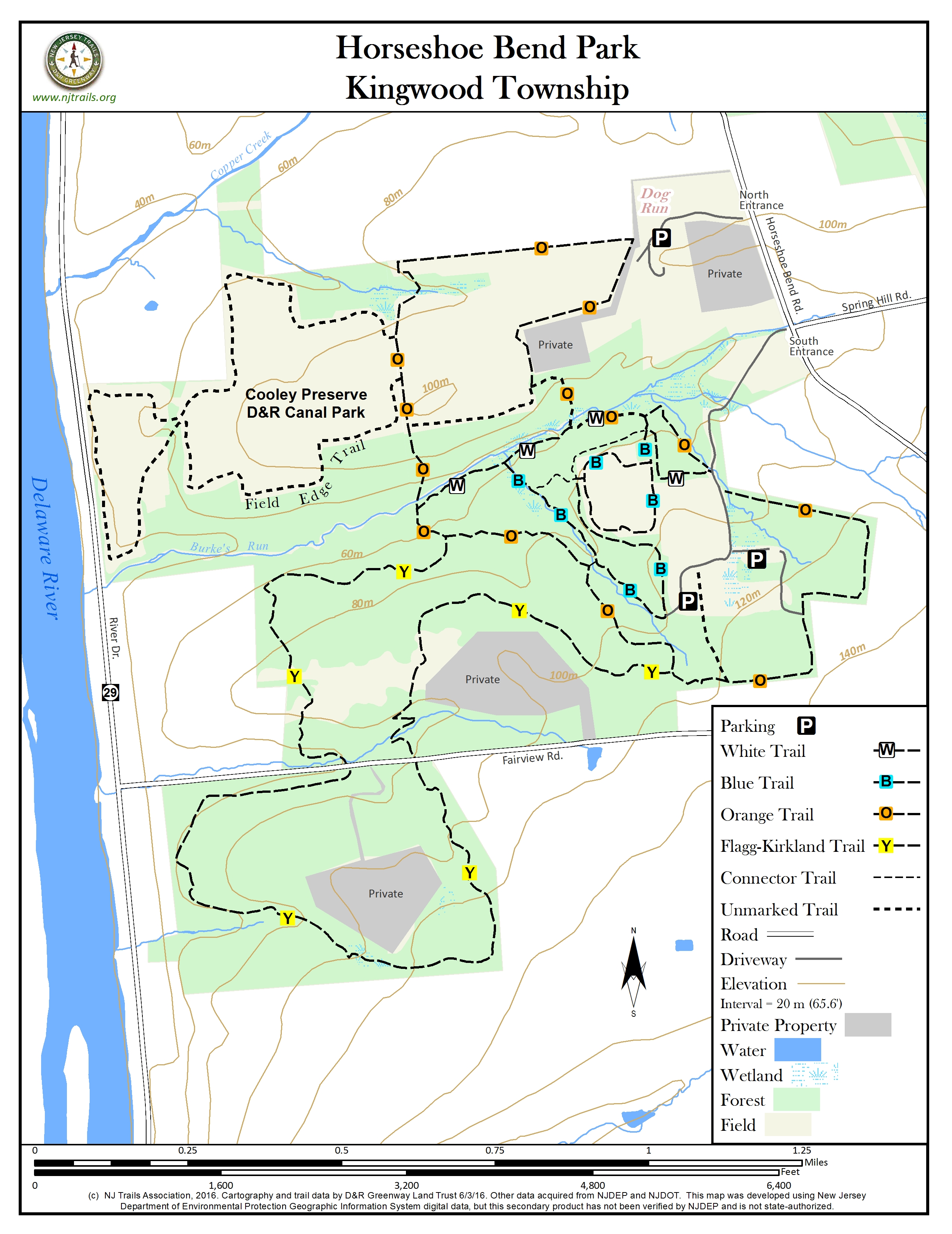
This 736-acre park, which includes the Copper Creek Preserve and the Cooley Preserve, is one of the most beautiful spots in western Hunterdon County, with rolling hills, lush forested ravines, and sweeping vistas of the Delaware River Valley. Its high meadows are home to a wide range of bird species. Copper Creek and other small streams flow through the park before tumbling down the bluffs into the Delaware River. Improvements on the property include a 10,000-square-foot enclosed event space, a seven acre “leash free” dog run area, as well as over 11 miles of existing trails.
-
-
Distance:
Total of more than 11 miles of trail.
Time:
Short and long walks, from 1-3 hours.
Markings:
Circular, rectangular, and diamond-shaped colored markers on trees. The Field Edge Trail in the Cooley Preserve is unmarked, but mowed. Where the Orange Trail crosses or skirts fields, there may be posts in the ground.
Trail Usage:
Hiking, biking, horseback riding
Elevation:
Trails that descend to near Route 29 on the western edge of the park get down to about 150 feet above sea level. Most of the trails range in elevation from 300-400 feet, but in the eastern corner of the park near Horseshoe Bend Road they rise to about 500 feet.
Difficulty:
Moderate. On the Orange Trail, there are two stretches of steep climb (30% grade), one about 200 and the other about 400 feet in length
Parking:
Parking is available at three locations. One parking lot is at the end of the public drive in from the north entrance (beyond this parking area the drive is private). There are also two parking lots off the south entrance driveway, one to the left (east) where the drive bends right (west), and a second further down this west branch of the drive
Tips:
None
Amenities:
None
Directions:
From Stockton: Go .5 mile north on Route 29, and turn right on Route 519 (Kingwood-Stockton Road). Follow Route 519 1.1 miles north to Rosemont, and then another 6.3 miles. Turn left on Spring Hill Road. Go 1.4 mile to the South Entrance directly across Horseshoe Bend Road, or turn right on Horseshoe Bend Road and go another .2 mile to the North Entrance on the left.
From Flemington: Take Route 12 west from Route 31 at the Flemington Circle. Go 8.4 miles, and turn left (south) on Route 519 (Kingwood-Stockton Road). Go 1.3 miles, then turn right on Spring Hill Road. Go 1.4 mile to the South Entrance directly across Horseshoe Bend Road, or turn right on Horseshoe Bend Road and go another .2 mile to the North Entrance on the left.
-
Located in western Hunterdon County, Horseshoe Bend Park offers forests, ravines and streams bordered to the north and east by preserved farms and to the west by the Delaware River. The park has over 11.5 miles of trails used for hiking, biking, horseback riding and bird watching. The park has a heated, 10,000 square foot Morton building, available to the public for events and meetings. The park is home to Hunterdon County’s largest leash free dog park (over 7 acres), the annual Horseshoe Bend Park horseback ride (attracting over 50 riders and their families), dog shows, geocaching sites, and horseback riding events. The park offers sweeping vistas of the Delaware River Valley, rolling hills, forested ravines and pristine streams, and offers habitat to many wildlife species.
Three trails form the framework for loop walks of varying lengths.
The Orange Trail, a 3.3 mile loop, traverses woods and fields around the perimeter of the northern portion of the park, crosses a tributary of Copper Creek near mile marker 0.9, and then climbs steeply to the southeastern portion of the loop just north of Fairview Road.
The Flagg-Kirkland Trail (marked with yellow diamonds) winds through oak, beech, and hemlock forests and crosses several small streams. The trail crosses Fairview Road and loops back after reaching the southern boundary of the park. Be on the lookout for pileated woodpeckers, hawks, and indigo buntings. Reached from the Orange Trail, this is a three and a half mile walk through the most diverse parts of the park.
The Blue Diamond Trail, is mostly a 1.2 mile loop around the perimeter of a former pasture. From the northwestern corner of the pasture, a short stem connects to a leg of the Blue Diamond Trail that loops south and then back to the northwest, providing connections to the western parking off the South Entrance driveway. Connections are also made from the Blue Diamond Trail to the Orange Trail and the White Trail.
In addition, three other trails can be used to create walk variations. The unmarked Field Edge Trail follows the edge of fields in the Cooley Preserve. It departs from the Orange Trail and forms a loop, descending counter-clockwise to near River Drive, and then returning to the Orange Trail a short distance south of its point of departure. The White Trail and the Equestrian Trail from short connectors between the eastern and western legs of the Orange Trail.
-
The park is home to a rich variety of wildlife. Bird species abound, from bald eagles, bobolinks, eastern meadowlark, great blue heron, thrushes, to various swallows, woodpeckers, and a long list of others identified in bird inventories. A total of 44 species of butterfly—37 of them resident–have been seen, including the very rare Gray Comma (Polygonia progne). Native wildflowers are abundant, along with, unfortunately, the invasive autumn olive.
Do you have information about this trail?
Click Here to contribute.
-
The New Jersey Conservation Foundation first sought to preserve the tract 10 years ago but could not reach an agreement with the landowner, who then sought to develop the site. But a public-private partnership subsequently put together a preservation funding plan. The first phase of the preservation took place in 2004, when 73 acres east of Horseshoe Bend Road in Kingwood Township were preserved at a cost of $1.7 million. The second phase of the preservation, targeting 240 acres also on the east side of Horseshoe Bend Road, was completed in July of 2005 at a cost of $5.8 million. Partners in Phase Two included the DEP’s Green Acres Program, DEP’s Office of Natural Resources Restoration, Kingwood Township’s Open Space Trust Fund, NJCF, and the Hunterdon Land Trust. The third phase of preservation took place in 2015 when 100 acres of land were added to the northeast of the park through the acquisition of the United Reformed Church property. Partners in this phase included the DEP’s Green Acres Program, and Hunterdon County Open Space Funds
Do you have information about this trail?
Click Here to contribute.
-
Photos
Videos